{"title":"利用光学、激光雷达和合成孔径雷达数据集进行洪水建模、绘图和分析--综述","authors":"I. Kubendiran, M. Ramaiah","doi":"10.1134/s0097807823600614","DOIUrl":null,"url":null,"abstract":"<h3 data-test=\"abstract-sub-heading\">Abstract</h3><p>Occurrence of natural disaster can never be prevented, and floods are one among the major natural disaster that affects the human life and economy of the country. Considering the global loss due to floods, various government and non-governmental organisations are focusing on minimising the losses and provide emergency measures during floods. Adopting the recent technologies integrating various datasets will assist in providing response strategies before and after disaster. Flood are mostly based on the climatic conditions and environmental factors and the present review focuses on the reviewing the various remote sensing methodologies that are used in mapping and analysing floods. The review carried out examines various remote sensing methodologies adopting multispectral, light detection and ranging and radar datasets for mapping and predicting floods. The review identified the limitations in flood prediction, risk assessment and hazard analysis and suggests a framework that can be adopted for effective mapping of flood extent and in suggesting the regions that the rescue team should focus during a disaster event.</p>","PeriodicalId":49368,"journal":{"name":"Water Resources","volume":"63 1","pages":""},"PeriodicalIF":0.9000,"publicationDate":"2024-07-10","publicationTypes":"Journal Article","fieldsOfStudy":null,"isOpenAccess":false,"openAccessPdf":"","citationCount":"0","resultStr":"{\"title\":\"Modeling, Mapping and Analysis of Floods Using Optical, Lidar and SAR Datasets—a Review\",\"authors\":\"I. Kubendiran, M. Ramaiah\",\"doi\":\"10.1134/s0097807823600614\",\"DOIUrl\":null,\"url\":null,\"abstract\":\"<h3 data-test=\\\"abstract-sub-heading\\\">Abstract</h3><p>Occurrence of natural disaster can never be prevented, and floods are one among the major natural disaster that affects the human life and economy of the country. Considering the global loss due to floods, various government and non-governmental organisations are focusing on minimising the losses and provide emergency measures during floods. Adopting the recent technologies integrating various datasets will assist in providing response strategies before and after disaster. Flood are mostly based on the climatic conditions and environmental factors and the present review focuses on the reviewing the various remote sensing methodologies that are used in mapping and analysing floods. The review carried out examines various remote sensing methodologies adopting multispectral, light detection and ranging and radar datasets for mapping and predicting floods. The review identified the limitations in flood prediction, risk assessment and hazard analysis and suggests a framework that can be adopted for effective mapping of flood extent and in suggesting the regions that the rescue team should focus during a disaster event.</p>\",\"PeriodicalId\":49368,\"journal\":{\"name\":\"Water Resources\",\"volume\":\"63 1\",\"pages\":\"\"},\"PeriodicalIF\":0.9000,\"publicationDate\":\"2024-07-10\",\"publicationTypes\":\"Journal Article\",\"fieldsOfStudy\":null,\"isOpenAccess\":false,\"openAccessPdf\":\"\",\"citationCount\":\"0\",\"resultStr\":null,\"platform\":\"Semanticscholar\",\"paperid\":null,\"PeriodicalName\":\"Water Resources\",\"FirstCategoryId\":\"93\",\"ListUrlMain\":\"https://doi.org/10.1134/s0097807823600614\",\"RegionNum\":4,\"RegionCategory\":\"环境科学与生态学\",\"ArticlePicture\":[],\"TitleCN\":null,\"AbstractTextCN\":null,\"PMCID\":null,\"EPubDate\":\"\",\"PubModel\":\"\",\"JCR\":\"Q4\",\"JCRName\":\"WATER RESOURCES\",\"Score\":null,\"Total\":0}","platform":"Semanticscholar","paperid":null,"PeriodicalName":"Water Resources","FirstCategoryId":"93","ListUrlMain":"https://doi.org/10.1134/s0097807823600614","RegionNum":4,"RegionCategory":"环境科学与生态学","ArticlePicture":[],"TitleCN":null,"AbstractTextCN":null,"PMCID":null,"EPubDate":"","PubModel":"","JCR":"Q4","JCRName":"WATER RESOURCES","Score":null,"Total":0}
Modeling, Mapping and Analysis of Floods Using Optical, Lidar and SAR Datasets—a Review
Abstract
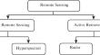
Occurrence of natural disaster can never be prevented, and floods are one among the major natural disaster that affects the human life and economy of the country. Considering the global loss due to floods, various government and non-governmental organisations are focusing on minimising the losses and provide emergency measures during floods. Adopting the recent technologies integrating various datasets will assist in providing response strategies before and after disaster. Flood are mostly based on the climatic conditions and environmental factors and the present review focuses on the reviewing the various remote sensing methodologies that are used in mapping and analysing floods. The review carried out examines various remote sensing methodologies adopting multispectral, light detection and ranging and radar datasets for mapping and predicting floods. The review identified the limitations in flood prediction, risk assessment and hazard analysis and suggests a framework that can be adopted for effective mapping of flood extent and in suggesting the regions that the rescue team should focus during a disaster event.
期刊介绍:
Water Resources is a journal that publishes articles on the assessment of water resources, integrated water resource use, water quality, and environmental protection. The journal covers many areas of research, including prediction of variations in continental water resources and regime; hydrophysical, hydrodynamic, hydrochemical and hydrobiological processes, environmental aspects of water quality and protection; economic, social, and legal aspects of water-resource development; and experimental methods of studies.
 求助内容:
求助内容: 应助结果提醒方式:


