Solange Uwamahoro , Tie Liu , Vincent Nzabarinda , Amaury Frankl , Etienne Tuyishimire , Angelique Iradukunda , Romaine Ingabire , Adeline Umugwaneza
{"title":"集水区地下水-地表水相互作用以及土地利用和土地覆盖变化调查,刚果民主共和国-卢旺达基伍湖案例","authors":"Solange Uwamahoro , Tie Liu , Vincent Nzabarinda , Amaury Frankl , Etienne Tuyishimire , Angelique Iradukunda , Romaine Ingabire , Adeline Umugwaneza","doi":"10.1016/j.gsd.2024.101236","DOIUrl":null,"url":null,"abstract":"<div><p>Groundwater is linked to climate change, land use, and land cover changes around the world. This research aims to enhance understanding of hydrological dynamics and environmental changes in the region for sustainable water resource management and conservation. It employs the Soil and Water Assessment Tool (SWAT) model and the standard Groundwater Level Index to determine the hydrological components, groundwater level, and fluctuations of the catchments over time. The model has been rerun with Global Climate Model (GCM) derived scenarios for predicting seasonal hydrological components. To assess changes in the land use and land cover around Kivu Lake, CA-Markov and regression analysis were also applied. Different calibration and validation schemes, as well as hydrological component patterns, were implemented. Across all catchments, streamflow ranged from 40.89 m<sup>3</sup>s<sup>−1</sup>–170.45 m<sup>3</sup>s<sup>−1</sup>, indicating a good fit between observed and simulated data. At Sake's northernmost point, a catchment's maximum average annual evapotranspiration was 1480.89 mm, with the same amount of precipitation, and the groundwater percolation rate ranged from 103.8 to 318.3 mmyr<sup>−1</sup>. According to the seasonal hydrological component trends, Shared Socioeconomic Pathway (SSP)119 predicted discharge ranging from 3.5% to 13.6% and SSP545 predicted discharge ranging from 1.8% to 10.83% for all catchments. Furthermore, under SSP119 and SSP545, average ET will range from 3.3% to 13.69% and from 4.33% to 15.63%, respectively. The 88.36% of the catchment from South Kivu in Kalehe district has shifted from forest to agriculture. This has the potential to dramatically alter percolation in the region. The findings of this research will assist decision-makers and resource managers in Kivu Lake catchments in making informed decisions regarding water allocation, land management practices, and conservation efforts.</p></div>","PeriodicalId":37879,"journal":{"name":"Groundwater for Sustainable Development","volume":null,"pages":null},"PeriodicalIF":4.9000,"publicationDate":"2024-06-15","publicationTypes":"Journal Article","fieldsOfStudy":null,"isOpenAccess":false,"openAccessPdf":"","citationCount":"0","resultStr":"{\"title\":\"Investigation of Groundwater–Surface water interaction and land use and land cover change in the catchments, A case of Kivu Lake, DRC-Rwanda\",\"authors\":\"Solange Uwamahoro , Tie Liu , Vincent Nzabarinda , Amaury Frankl , Etienne Tuyishimire , Angelique Iradukunda , Romaine Ingabire , Adeline Umugwaneza\",\"doi\":\"10.1016/j.gsd.2024.101236\",\"DOIUrl\":null,\"url\":null,\"abstract\":\"<div><p>Groundwater is linked to climate change, land use, and land cover changes around the world. This research aims to enhance understanding of hydrological dynamics and environmental changes in the region for sustainable water resource management and conservation. It employs the Soil and Water Assessment Tool (SWAT) model and the standard Groundwater Level Index to determine the hydrological components, groundwater level, and fluctuations of the catchments over time. The model has been rerun with Global Climate Model (GCM) derived scenarios for predicting seasonal hydrological components. To assess changes in the land use and land cover around Kivu Lake, CA-Markov and regression analysis were also applied. Different calibration and validation schemes, as well as hydrological component patterns, were implemented. Across all catchments, streamflow ranged from 40.89 m<sup>3</sup>s<sup>−1</sup>–170.45 m<sup>3</sup>s<sup>−1</sup>, indicating a good fit between observed and simulated data. At Sake's northernmost point, a catchment's maximum average annual evapotranspiration was 1480.89 mm, with the same amount of precipitation, and the groundwater percolation rate ranged from 103.8 to 318.3 mmyr<sup>−1</sup>. According to the seasonal hydrological component trends, Shared Socioeconomic Pathway (SSP)119 predicted discharge ranging from 3.5% to 13.6% and SSP545 predicted discharge ranging from 1.8% to 10.83% for all catchments. Furthermore, under SSP119 and SSP545, average ET will range from 3.3% to 13.69% and from 4.33% to 15.63%, respectively. The 88.36% of the catchment from South Kivu in Kalehe district has shifted from forest to agriculture. This has the potential to dramatically alter percolation in the region. The findings of this research will assist decision-makers and resource managers in Kivu Lake catchments in making informed decisions regarding water allocation, land management practices, and conservation efforts.</p></div>\",\"PeriodicalId\":37879,\"journal\":{\"name\":\"Groundwater for Sustainable Development\",\"volume\":null,\"pages\":null},\"PeriodicalIF\":4.9000,\"publicationDate\":\"2024-06-15\",\"publicationTypes\":\"Journal Article\",\"fieldsOfStudy\":null,\"isOpenAccess\":false,\"openAccessPdf\":\"\",\"citationCount\":\"0\",\"resultStr\":null,\"platform\":\"Semanticscholar\",\"paperid\":null,\"PeriodicalName\":\"Groundwater for Sustainable Development\",\"FirstCategoryId\":\"1085\",\"ListUrlMain\":\"https://www.sciencedirect.com/science/article/pii/S2352801X24001590\",\"RegionNum\":0,\"RegionCategory\":null,\"ArticlePicture\":[],\"TitleCN\":null,\"AbstractTextCN\":null,\"PMCID\":null,\"EPubDate\":\"\",\"PubModel\":\"\",\"JCR\":\"Q2\",\"JCRName\":\"ENGINEERING, ENVIRONMENTAL\",\"Score\":null,\"Total\":0}","platform":"Semanticscholar","paperid":null,"PeriodicalName":"Groundwater for Sustainable Development","FirstCategoryId":"1085","ListUrlMain":"https://www.sciencedirect.com/science/article/pii/S2352801X24001590","RegionNum":0,"RegionCategory":null,"ArticlePicture":[],"TitleCN":null,"AbstractTextCN":null,"PMCID":null,"EPubDate":"","PubModel":"","JCR":"Q2","JCRName":"ENGINEERING, ENVIRONMENTAL","Score":null,"Total":0}
Investigation of Groundwater–Surface water interaction and land use and land cover change in the catchments, A case of Kivu Lake, DRC-Rwanda
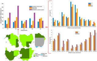
Groundwater is linked to climate change, land use, and land cover changes around the world. This research aims to enhance understanding of hydrological dynamics and environmental changes in the region for sustainable water resource management and conservation. It employs the Soil and Water Assessment Tool (SWAT) model and the standard Groundwater Level Index to determine the hydrological components, groundwater level, and fluctuations of the catchments over time. The model has been rerun with Global Climate Model (GCM) derived scenarios for predicting seasonal hydrological components. To assess changes in the land use and land cover around Kivu Lake, CA-Markov and regression analysis were also applied. Different calibration and validation schemes, as well as hydrological component patterns, were implemented. Across all catchments, streamflow ranged from 40.89 m3s−1–170.45 m3s−1, indicating a good fit between observed and simulated data. At Sake's northernmost point, a catchment's maximum average annual evapotranspiration was 1480.89 mm, with the same amount of precipitation, and the groundwater percolation rate ranged from 103.8 to 318.3 mmyr−1. According to the seasonal hydrological component trends, Shared Socioeconomic Pathway (SSP)119 predicted discharge ranging from 3.5% to 13.6% and SSP545 predicted discharge ranging from 1.8% to 10.83% for all catchments. Furthermore, under SSP119 and SSP545, average ET will range from 3.3% to 13.69% and from 4.33% to 15.63%, respectively. The 88.36% of the catchment from South Kivu in Kalehe district has shifted from forest to agriculture. This has the potential to dramatically alter percolation in the region. The findings of this research will assist decision-makers and resource managers in Kivu Lake catchments in making informed decisions regarding water allocation, land management practices, and conservation efforts.
期刊介绍:
Groundwater for Sustainable Development is directed to different stakeholders and professionals, including government and non-governmental organizations, international funding agencies, universities, public water institutions, public health and other public/private sector professionals, and other relevant institutions. It is aimed at professionals, academics and students in the fields of disciplines such as: groundwater and its connection to surface hydrology and environment, soil sciences, engineering, ecology, microbiology, atmospheric sciences, analytical chemistry, hydro-engineering, water technology, environmental ethics, economics, public health, policy, as well as social sciences, legal disciplines, or any other area connected with water issues. The objectives of this journal are to facilitate: • The improvement of effective and sustainable management of water resources across the globe. • The improvement of human access to groundwater resources in adequate quantity and good quality. • The meeting of the increasing demand for drinking and irrigation water needed for food security to contribute to a social and economically sound human development. • The creation of a global inter- and multidisciplinary platform and forum to improve our understanding of groundwater resources and to advocate their effective and sustainable management and protection against contamination. • Interdisciplinary information exchange and to stimulate scientific research in the fields of groundwater related sciences and social and health sciences required to achieve the United Nations Millennium Development Goals for sustainable development.

 求助内容:
求助内容: 应助结果提醒方式:


