T. Naish, R. Levy, I. Hamling, S. Hreinsdóttir, P. Kumar, G. G. Garner, R. E. Kopp, N. Golledge, R. Bell, R. Paulik, J. Lawrence, P. Denys, T. Gillies, S. Bengtson, A. Howell, K. Clark, D. King, N. Litchfield, R. Newnham
{"title":"聚合板块边界地震间垂直陆地运动在 AR6 情景的概率海平面预测中的重要性:新西兰案例","authors":"T. Naish, R. Levy, I. Hamling, S. Hreinsdóttir, P. Kumar, G. G. Garner, R. E. Kopp, N. Golledge, R. Bell, R. Paulik, J. Lawrence, P. Denys, T. Gillies, S. Bengtson, A. Howell, K. Clark, D. King, N. Litchfield, R. Newnham","doi":"10.1029/2023EF004165","DOIUrl":null,"url":null,"abstract":"<p>Anticipating and managing the impacts of sea-level rise for nations astride active tectonic margins requires understanding of rates of sea surface elevation change in relation to coastal land elevation. Vertical land motion (VLM) can either exacerbate or reduce sea-level changes with impacts varying significantly along a coastline. Determining rate, pattern, and variability of VLM near coasts leads to a direct improvement of location-specific relative sea level (RSL) estimates for coastal hazard risk assessment. Here, we utilize vertical velocity field from interferometric synthetic aperture radar (InSAR) data, calibrated with campaign and continuous Global Navigation Satellite System data, to determine the VLM for the entire coastline of New Zealand. Guided by available knowledge of the seismic cycle, the VLM data infer secular, interseismic rates of land surface deformation. Using the Framework for Assessing Changes to Sea-level (FACTS), we build probabilistic RSL projections using the same emissions scenarios employed in IPCC Assessment Report 6 and local VLM data at 8,179 sites, thereby enhancing spatial coverage that was previously limited to four tide gauges. We present ensembles of probability distributions of RSL for each scenario to 2150, and for <i>low confidence</i> sea-level processes to 2300. Where land subsidence is occurring at rates >2 mm/y VLM makes a significant contribution to RSL projections for all scenarios out to 2150. Our approach can be applied to similar locations across the world and has significant implications for adaptation planning, as timing of threshold exceedance for coastal inundation can be brought forward (or delayed) by decades.</p>","PeriodicalId":48748,"journal":{"name":"Earths Future","volume":"12 6","pages":""},"PeriodicalIF":7.3000,"publicationDate":"2024-06-06","publicationTypes":"Journal Article","fieldsOfStudy":null,"isOpenAccess":false,"openAccessPdf":"https://onlinelibrary.wiley.com/doi/epdf/10.1029/2023EF004165","citationCount":"0","resultStr":"{\"title\":\"The Significance of Interseismic Vertical Land Movement at Convergent Plate Boundaries in Probabilistic Sea-Level Projections for AR6 Scenarios: The New Zealand Case\",\"authors\":\"T. Naish, R. Levy, I. Hamling, S. Hreinsdóttir, P. Kumar, G. G. Garner, R. E. Kopp, N. Golledge, R. Bell, R. Paulik, J. Lawrence, P. Denys, T. Gillies, S. Bengtson, A. Howell, K. Clark, D. King, N. Litchfield, R. Newnham\",\"doi\":\"10.1029/2023EF004165\",\"DOIUrl\":null,\"url\":null,\"abstract\":\"<p>Anticipating and managing the impacts of sea-level rise for nations astride active tectonic margins requires understanding of rates of sea surface elevation change in relation to coastal land elevation. Vertical land motion (VLM) can either exacerbate or reduce sea-level changes with impacts varying significantly along a coastline. Determining rate, pattern, and variability of VLM near coasts leads to a direct improvement of location-specific relative sea level (RSL) estimates for coastal hazard risk assessment. Here, we utilize vertical velocity field from interferometric synthetic aperture radar (InSAR) data, calibrated with campaign and continuous Global Navigation Satellite System data, to determine the VLM for the entire coastline of New Zealand. Guided by available knowledge of the seismic cycle, the VLM data infer secular, interseismic rates of land surface deformation. Using the Framework for Assessing Changes to Sea-level (FACTS), we build probabilistic RSL projections using the same emissions scenarios employed in IPCC Assessment Report 6 and local VLM data at 8,179 sites, thereby enhancing spatial coverage that was previously limited to four tide gauges. We present ensembles of probability distributions of RSL for each scenario to 2150, and for <i>low confidence</i> sea-level processes to 2300. Where land subsidence is occurring at rates >2 mm/y VLM makes a significant contribution to RSL projections for all scenarios out to 2150. Our approach can be applied to similar locations across the world and has significant implications for adaptation planning, as timing of threshold exceedance for coastal inundation can be brought forward (or delayed) by decades.</p>\",\"PeriodicalId\":48748,\"journal\":{\"name\":\"Earths Future\",\"volume\":\"12 6\",\"pages\":\"\"},\"PeriodicalIF\":7.3000,\"publicationDate\":\"2024-06-06\",\"publicationTypes\":\"Journal Article\",\"fieldsOfStudy\":null,\"isOpenAccess\":false,\"openAccessPdf\":\"https://onlinelibrary.wiley.com/doi/epdf/10.1029/2023EF004165\",\"citationCount\":\"0\",\"resultStr\":null,\"platform\":\"Semanticscholar\",\"paperid\":null,\"PeriodicalName\":\"Earths Future\",\"FirstCategoryId\":\"89\",\"ListUrlMain\":\"https://onlinelibrary.wiley.com/doi/10.1029/2023EF004165\",\"RegionNum\":1,\"RegionCategory\":\"地球科学\",\"ArticlePicture\":[],\"TitleCN\":null,\"AbstractTextCN\":null,\"PMCID\":null,\"EPubDate\":\"\",\"PubModel\":\"\",\"JCR\":\"Q1\",\"JCRName\":\"ENVIRONMENTAL SCIENCES\",\"Score\":null,\"Total\":0}","platform":"Semanticscholar","paperid":null,"PeriodicalName":"Earths Future","FirstCategoryId":"89","ListUrlMain":"https://onlinelibrary.wiley.com/doi/10.1029/2023EF004165","RegionNum":1,"RegionCategory":"地球科学","ArticlePicture":[],"TitleCN":null,"AbstractTextCN":null,"PMCID":null,"EPubDate":"","PubModel":"","JCR":"Q1","JCRName":"ENVIRONMENTAL SCIENCES","Score":null,"Total":0}
The Significance of Interseismic Vertical Land Movement at Convergent Plate Boundaries in Probabilistic Sea-Level Projections for AR6 Scenarios: The New Zealand Case
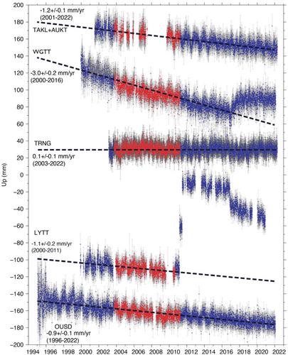
Anticipating and managing the impacts of sea-level rise for nations astride active tectonic margins requires understanding of rates of sea surface elevation change in relation to coastal land elevation. Vertical land motion (VLM) can either exacerbate or reduce sea-level changes with impacts varying significantly along a coastline. Determining rate, pattern, and variability of VLM near coasts leads to a direct improvement of location-specific relative sea level (RSL) estimates for coastal hazard risk assessment. Here, we utilize vertical velocity field from interferometric synthetic aperture radar (InSAR) data, calibrated with campaign and continuous Global Navigation Satellite System data, to determine the VLM for the entire coastline of New Zealand. Guided by available knowledge of the seismic cycle, the VLM data infer secular, interseismic rates of land surface deformation. Using the Framework for Assessing Changes to Sea-level (FACTS), we build probabilistic RSL projections using the same emissions scenarios employed in IPCC Assessment Report 6 and local VLM data at 8,179 sites, thereby enhancing spatial coverage that was previously limited to four tide gauges. We present ensembles of probability distributions of RSL for each scenario to 2150, and for low confidence sea-level processes to 2300. Where land subsidence is occurring at rates >2 mm/y VLM makes a significant contribution to RSL projections for all scenarios out to 2150. Our approach can be applied to similar locations across the world and has significant implications for adaptation planning, as timing of threshold exceedance for coastal inundation can be brought forward (or delayed) by decades.
期刊介绍:
Earth’s Future: A transdisciplinary open access journal, Earth’s Future focuses on the state of the Earth and the prediction of the planet’s future. By publishing peer-reviewed articles as well as editorials, essays, reviews, and commentaries, this journal will be the preeminent scholarly resource on the Anthropocene. It will also help assess the risks and opportunities associated with environmental changes and challenges.
 求助内容:
求助内容: 应助结果提醒方式:


