{"title":"利用卫星遥感和随机森林机器学习算法预测亚高山草地的物种丰富度和多样性","authors":"Katlego Mashiane, Abel Ramoelo, Samuel Adelabu","doi":"10.1111/avsc.12778","DOIUrl":null,"url":null,"abstract":"<div>\n \n \n <section>\n \n <h3> Aims</h3>\n \n <p>Remote-sensing approaches could be beneficial for monitoring and compiling essential biodiversity data because they are cost-effective and allow for coverage of large areas over a short period. This study investigated the relationship between multispectral remote-sensing data from Landsat 8 and Sentinel-2 and species richness and diversity in mountainous and protected grasslands.</p>\n </section>\n \n <section>\n \n <h3> Locations</h3>\n \n <p>Golden Gate Highlands National Park, Free State, South Africa.</p>\n </section>\n \n <section>\n \n <h3> Methods</h3>\n \n <p><i>In-situ</i> data of plant species composition and cover from 142 plots with 16 relevés each were distributed across the study site and used to calculate species richness and Shannon–Wiener species diversity index (species diversity). We used a machine-learning random forest algorithm to optimize the prediction of species richness and diversity. The algorithm was used to identify the optimal spectral bands and vegetation indices for estimating species richness and diversity. Subsequently, the selected bands and vegetation indices were used to estimate species richness through random forest regression.</p>\n </section>\n \n <section>\n \n <h3> Results</h3>\n \n <p>This research found weak relationships between remote-sensing vegetation indices and the diversity metrics, but significant relationships were found between some spectral bands and diversity metrics. Moreover, using machine-learning random forest, the multispectral data sets exhibited strong predictive powers. In this investigation, near-infrared (NIR) seemed to be the most selected band for both sensors to explain species diversity in mountainous grasslands.</p>\n </section>\n \n <section>\n \n <h3> Main conclusions</h3>\n \n <p>This finding further ascertains the efficiency of optimizing high spatial resolution spectral information to estimate plant species richness and diversity. This research shows that NIR, Soil-Adjusted Vegetation Index (SAVI) and Enhanced Vegetation Index (EVI) are the most adequate for predicting species richness and diversity in mountainous grasslands with relatively good accuracies. Plant phenology and the choice of sensor affect the relationship between spectral information and species diversity variables.</p>\n </section>\n </div>","PeriodicalId":55494,"journal":{"name":"Applied Vegetation Science","volume":"27 2","pages":""},"PeriodicalIF":2.6000,"publicationDate":"2024-06-04","publicationTypes":"Journal Article","fieldsOfStudy":null,"isOpenAccess":false,"openAccessPdf":"https://onlinelibrary.wiley.com/doi/epdf/10.1111/avsc.12778","citationCount":"0","resultStr":"{\"title\":\"Prediction of species richness and diversity in sub-alpine grasslands using satellite remote sensing and random forest machine-learning algorithm\",\"authors\":\"Katlego Mashiane, Abel Ramoelo, Samuel Adelabu\",\"doi\":\"10.1111/avsc.12778\",\"DOIUrl\":null,\"url\":null,\"abstract\":\"<div>\\n \\n \\n <section>\\n \\n <h3> Aims</h3>\\n \\n <p>Remote-sensing approaches could be beneficial for monitoring and compiling essential biodiversity data because they are cost-effective and allow for coverage of large areas over a short period. This study investigated the relationship between multispectral remote-sensing data from Landsat 8 and Sentinel-2 and species richness and diversity in mountainous and protected grasslands.</p>\\n </section>\\n \\n <section>\\n \\n <h3> Locations</h3>\\n \\n <p>Golden Gate Highlands National Park, Free State, South Africa.</p>\\n </section>\\n \\n <section>\\n \\n <h3> Methods</h3>\\n \\n <p><i>In-situ</i> data of plant species composition and cover from 142 plots with 16 relevés each were distributed across the study site and used to calculate species richness and Shannon–Wiener species diversity index (species diversity). We used a machine-learning random forest algorithm to optimize the prediction of species richness and diversity. The algorithm was used to identify the optimal spectral bands and vegetation indices for estimating species richness and diversity. Subsequently, the selected bands and vegetation indices were used to estimate species richness through random forest regression.</p>\\n </section>\\n \\n <section>\\n \\n <h3> Results</h3>\\n \\n <p>This research found weak relationships between remote-sensing vegetation indices and the diversity metrics, but significant relationships were found between some spectral bands and diversity metrics. Moreover, using machine-learning random forest, the multispectral data sets exhibited strong predictive powers. In this investigation, near-infrared (NIR) seemed to be the most selected band for both sensors to explain species diversity in mountainous grasslands.</p>\\n </section>\\n \\n <section>\\n \\n <h3> Main conclusions</h3>\\n \\n <p>This finding further ascertains the efficiency of optimizing high spatial resolution spectral information to estimate plant species richness and diversity. This research shows that NIR, Soil-Adjusted Vegetation Index (SAVI) and Enhanced Vegetation Index (EVI) are the most adequate for predicting species richness and diversity in mountainous grasslands with relatively good accuracies. Plant phenology and the choice of sensor affect the relationship between spectral information and species diversity variables.</p>\\n </section>\\n </div>\",\"PeriodicalId\":55494,\"journal\":{\"name\":\"Applied Vegetation Science\",\"volume\":\"27 2\",\"pages\":\"\"},\"PeriodicalIF\":2.6000,\"publicationDate\":\"2024-06-04\",\"publicationTypes\":\"Journal Article\",\"fieldsOfStudy\":null,\"isOpenAccess\":false,\"openAccessPdf\":\"https://onlinelibrary.wiley.com/doi/epdf/10.1111/avsc.12778\",\"citationCount\":\"0\",\"resultStr\":null,\"platform\":\"Semanticscholar\",\"paperid\":null,\"PeriodicalName\":\"Applied Vegetation Science\",\"FirstCategoryId\":\"93\",\"ListUrlMain\":\"https://onlinelibrary.wiley.com/doi/10.1111/avsc.12778\",\"RegionNum\":3,\"RegionCategory\":\"环境科学与生态学\",\"ArticlePicture\":[],\"TitleCN\":null,\"AbstractTextCN\":null,\"PMCID\":null,\"EPubDate\":\"\",\"PubModel\":\"\",\"JCR\":\"Q3\",\"JCRName\":\"ECOLOGY\",\"Score\":null,\"Total\":0}","platform":"Semanticscholar","paperid":null,"PeriodicalName":"Applied Vegetation Science","FirstCategoryId":"93","ListUrlMain":"https://onlinelibrary.wiley.com/doi/10.1111/avsc.12778","RegionNum":3,"RegionCategory":"环境科学与生态学","ArticlePicture":[],"TitleCN":null,"AbstractTextCN":null,"PMCID":null,"EPubDate":"","PubModel":"","JCR":"Q3","JCRName":"ECOLOGY","Score":null,"Total":0}
Prediction of species richness and diversity in sub-alpine grasslands using satellite remote sensing and random forest machine-learning algorithm
Aims
Remote-sensing approaches could be beneficial for monitoring and compiling essential biodiversity data because they are cost-effective and allow for coverage of large areas over a short period. This study investigated the relationship between multispectral remote-sensing data from Landsat 8 and Sentinel-2 and species richness and diversity in mountainous and protected grasslands.
Locations
Golden Gate Highlands National Park, Free State, South Africa.
Methods
In-situ data of plant species composition and cover from 142 plots with 16 relevés each were distributed across the study site and used to calculate species richness and Shannon–Wiener species diversity index (species diversity). We used a machine-learning random forest algorithm to optimize the prediction of species richness and diversity. The algorithm was used to identify the optimal spectral bands and vegetation indices for estimating species richness and diversity. Subsequently, the selected bands and vegetation indices were used to estimate species richness through random forest regression.
Results
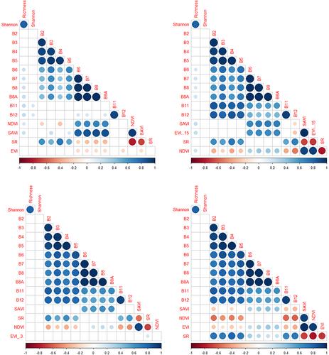
This research found weak relationships between remote-sensing vegetation indices and the diversity metrics, but significant relationships were found between some spectral bands and diversity metrics. Moreover, using machine-learning random forest, the multispectral data sets exhibited strong predictive powers. In this investigation, near-infrared (NIR) seemed to be the most selected band for both sensors to explain species diversity in mountainous grasslands.
Main conclusions
This finding further ascertains the efficiency of optimizing high spatial resolution spectral information to estimate plant species richness and diversity. This research shows that NIR, Soil-Adjusted Vegetation Index (SAVI) and Enhanced Vegetation Index (EVI) are the most adequate for predicting species richness and diversity in mountainous grasslands with relatively good accuracies. Plant phenology and the choice of sensor affect the relationship between spectral information and species diversity variables.
期刊介绍:
Applied Vegetation Science focuses on community-level topics relevant to human interaction with vegetation, including global change, nature conservation, nature management, restoration of plant communities and of natural habitats, and the planning of semi-natural and urban landscapes. Vegetation survey, modelling and remote-sensing applications are welcome. Papers on vegetation science which do not fit to this scope (do not have an applied aspect and are not vegetation survey) should be directed to our associate journal, the Journal of Vegetation Science. Both journals publish papers on the ecology of a single species only if it plays a key role in structuring plant communities.
 求助内容:
求助内容: 应助结果提醒方式:


