{"title":"利用 AVIRIS-NG 高光谱图像绘制矿物图的基于堆叠集合学习的框架","authors":"Ram Nivas Giri, Rekh Ram Janghel, Himanshu Govil, Gaurav Mishra","doi":"10.1007/s12040-024-02317-z","DOIUrl":null,"url":null,"abstract":"<h3 data-test=\"abstract-sub-heading\">Abstract</h3><p>Hyperspectral data has a significant count of spectral channels with an enhanced spectral resolution, which provides detailed information at each pixel. This data can be used in numerous remote sensing (RS) applications, along with mineral mapping. Mineral mapping is an important component of geological mapping, which helps in investigating the mineralization potential of an area. This work can be completed effectively by applying machine learning (ML) techniques to RS data. This paper proposes a stacked ensemble-based framework for mineral mapping using the dataset obtained by the Airborne Visible Infrared Imaging Spectrometer-Next Generation (AVIRIS-NG). The study area is situated in Jahazpur, Rajasthan, India. The purpose of this stacked ensemble-based model is to enhance the performance of ML-based mineral mapping. The proposed stacked ensemble model consists of two major elements: a base learner (Naïve Bayes, KNN, artificial neural network, decision tree, and support vector machine) and a stacked learner (random forest). The results of the experiments show that the stacked ensemble-based model has a lot of potential for accurately mapping the minerals talc, montmorillonite, kaolionite, and kaosmec. The proposed model has obtained an overall accuracy of 98.96%, an average accuracy of 98.21%, and a Kappa coefficient of 0.9628.</p><h3 data-test=\"abstract-sub-heading\">Research highlights</h3>\n<ul>\n<li>\n<p>A stacked ensemble-based model for mineral mapping is proposed.</p>\n</li>\n<li>\n<p>The well-known five conventional machine learning models (called base models) are investigated for mineral mapping.</p>\n</li>\n<li>\n<p>The performance of the proposed model is evaluated on the AVIRIG–NG dataset. The study area is situated in Jahazpur, Rajasthan, India.</p>\n</li>\n<li>\n<p>The proposed method outperformed all base models.</p>\n</li>\n</ul>","PeriodicalId":15609,"journal":{"name":"Journal of Earth System Science","volume":"42 1","pages":""},"PeriodicalIF":1.7000,"publicationDate":"2024-05-30","publicationTypes":"Journal Article","fieldsOfStudy":null,"isOpenAccess":false,"openAccessPdf":"","citationCount":"0","resultStr":"{\"title\":\"A stacked ensemble learning-based framework for mineral mapping using AVIRIS-NG hyperspectral image\",\"authors\":\"Ram Nivas Giri, Rekh Ram Janghel, Himanshu Govil, Gaurav Mishra\",\"doi\":\"10.1007/s12040-024-02317-z\",\"DOIUrl\":null,\"url\":null,\"abstract\":\"<h3 data-test=\\\"abstract-sub-heading\\\">Abstract</h3><p>Hyperspectral data has a significant count of spectral channels with an enhanced spectral resolution, which provides detailed information at each pixel. This data can be used in numerous remote sensing (RS) applications, along with mineral mapping. Mineral mapping is an important component of geological mapping, which helps in investigating the mineralization potential of an area. This work can be completed effectively by applying machine learning (ML) techniques to RS data. This paper proposes a stacked ensemble-based framework for mineral mapping using the dataset obtained by the Airborne Visible Infrared Imaging Spectrometer-Next Generation (AVIRIS-NG). The study area is situated in Jahazpur, Rajasthan, India. The purpose of this stacked ensemble-based model is to enhance the performance of ML-based mineral mapping. The proposed stacked ensemble model consists of two major elements: a base learner (Naïve Bayes, KNN, artificial neural network, decision tree, and support vector machine) and a stacked learner (random forest). The results of the experiments show that the stacked ensemble-based model has a lot of potential for accurately mapping the minerals talc, montmorillonite, kaolionite, and kaosmec. The proposed model has obtained an overall accuracy of 98.96%, an average accuracy of 98.21%, and a Kappa coefficient of 0.9628.</p><h3 data-test=\\\"abstract-sub-heading\\\">Research highlights</h3>\\n<ul>\\n<li>\\n<p>A stacked ensemble-based model for mineral mapping is proposed.</p>\\n</li>\\n<li>\\n<p>The well-known five conventional machine learning models (called base models) are investigated for mineral mapping.</p>\\n</li>\\n<li>\\n<p>The performance of the proposed model is evaluated on the AVIRIG–NG dataset. The study area is situated in Jahazpur, Rajasthan, India.</p>\\n</li>\\n<li>\\n<p>The proposed method outperformed all base models.</p>\\n</li>\\n</ul>\",\"PeriodicalId\":15609,\"journal\":{\"name\":\"Journal of Earth System Science\",\"volume\":\"42 1\",\"pages\":\"\"},\"PeriodicalIF\":1.7000,\"publicationDate\":\"2024-05-30\",\"publicationTypes\":\"Journal Article\",\"fieldsOfStudy\":null,\"isOpenAccess\":false,\"openAccessPdf\":\"\",\"citationCount\":\"0\",\"resultStr\":null,\"platform\":\"Semanticscholar\",\"paperid\":null,\"PeriodicalName\":\"Journal of Earth System Science\",\"FirstCategoryId\":\"89\",\"ListUrlMain\":\"https://doi.org/10.1007/s12040-024-02317-z\",\"RegionNum\":4,\"RegionCategory\":\"地球科学\",\"ArticlePicture\":[],\"TitleCN\":null,\"AbstractTextCN\":null,\"PMCID\":null,\"EPubDate\":\"\",\"PubModel\":\"\",\"JCR\":\"Q3\",\"JCRName\":\"GEOSCIENCES, MULTIDISCIPLINARY\",\"Score\":null,\"Total\":0}","platform":"Semanticscholar","paperid":null,"PeriodicalName":"Journal of Earth System Science","FirstCategoryId":"89","ListUrlMain":"https://doi.org/10.1007/s12040-024-02317-z","RegionNum":4,"RegionCategory":"地球科学","ArticlePicture":[],"TitleCN":null,"AbstractTextCN":null,"PMCID":null,"EPubDate":"","PubModel":"","JCR":"Q3","JCRName":"GEOSCIENCES, MULTIDISCIPLINARY","Score":null,"Total":0}
引用次数: 0
摘要
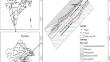
摘要 高光谱数据具有大量光谱通道,光谱分辨率更高,可提供每个像素的详细信息。这种数据可用于多种遥感(RS)应用以及矿物测绘。矿物测绘是地质测绘的重要组成部分,有助于调查一个地区的成矿潜力。将机器学习(ML)技术应用于遥感数据可以有效地完成这项工作。本文利用机载可见红外成像光谱仪-下一代(AVIRIS-NG)获得的数据集,提出了一种基于堆叠集合的矿产绘图框架。研究区域位于印度拉贾斯坦邦的贾哈兹布尔。该基于叠加集合的模型旨在提高基于 ML 的矿物测绘性能。所提议的堆叠集合模型由两个主要元素组成:基础学习器(奈夫贝叶斯、KNN、人工神经网络、决策树和支持向量机)和堆叠学习器(随机森林)。实验结果表明,基于堆叠集合的模型在精确绘制滑石、蒙脱石、高岭土和高斯米克矿物图谱方面具有很大的潜力。提出的模型总体准确率为 98.96%,平均准确率为 98.21%,Kappa 系数为 0.9628。研究要点提出了基于堆叠集合的矿物测绘模型,研究了用于矿物测绘的著名的五种传统机器学习模型(称为基础模型)。研究区域位于印度拉贾斯坦邦的 Jahazpur。
A stacked ensemble learning-based framework for mineral mapping using AVIRIS-NG hyperspectral image
Abstract
Hyperspectral data has a significant count of spectral channels with an enhanced spectral resolution, which provides detailed information at each pixel. This data can be used in numerous remote sensing (RS) applications, along with mineral mapping. Mineral mapping is an important component of geological mapping, which helps in investigating the mineralization potential of an area. This work can be completed effectively by applying machine learning (ML) techniques to RS data. This paper proposes a stacked ensemble-based framework for mineral mapping using the dataset obtained by the Airborne Visible Infrared Imaging Spectrometer-Next Generation (AVIRIS-NG). The study area is situated in Jahazpur, Rajasthan, India. The purpose of this stacked ensemble-based model is to enhance the performance of ML-based mineral mapping. The proposed stacked ensemble model consists of two major elements: a base learner (Naïve Bayes, KNN, artificial neural network, decision tree, and support vector machine) and a stacked learner (random forest). The results of the experiments show that the stacked ensemble-based model has a lot of potential for accurately mapping the minerals talc, montmorillonite, kaolionite, and kaosmec. The proposed model has obtained an overall accuracy of 98.96%, an average accuracy of 98.21%, and a Kappa coefficient of 0.9628.
Research highlights
A stacked ensemble-based model for mineral mapping is proposed.
The well-known five conventional machine learning models (called base models) are investigated for mineral mapping.
The performance of the proposed model is evaluated on the AVIRIG–NG dataset. The study area is situated in Jahazpur, Rajasthan, India.
期刊介绍:
The Journal of Earth System Science, an International Journal, was earlier a part of the Proceedings of the Indian Academy of Sciences – Section A begun in 1934, and later split in 1978 into theme journals. This journal was published as Proceedings – Earth and Planetary Sciences since 1978, and in 2005 was renamed ‘Journal of Earth System Science’.
The journal is highly inter-disciplinary and publishes scholarly research – new data, ideas, and conceptual advances – in Earth System Science. The focus is on the evolution of the Earth as a system: manuscripts describing changes of anthropogenic origin in a limited region are not considered unless they go beyond describing the changes to include an analysis of earth-system processes. The journal''s scope includes the solid earth (geosphere), the atmosphere, the hydrosphere (including cryosphere), and the biosphere; it also addresses related aspects of planetary and space sciences. Contributions pertaining to the Indian sub- continent and the surrounding Indian-Ocean region are particularly welcome. Given that a large number of manuscripts report either observations or model results for a limited domain, manuscripts intended for publication in JESS are expected to fulfill at least one of the following three criteria.
The data should be of relevance and should be of statistically significant size and from a region from where such data are sparse. If the data are from a well-sampled region, the data size should be considerable and advance our knowledge of the region.
A model study is carried out to explain observations reported either in the same manuscript or in the literature.
The analysis, whether of data or with models, is novel and the inferences advance the current knowledge.
 求助内容:
求助内容: 应助结果提醒方式:


