{"title":"利用 PS 干涉测量法和 PSDS InSAR 了解乔希马什山体滑坡","authors":"Asrar Ahmad Rather, Syed Kaiser Bukhari","doi":"10.1007/s12040-024-02312-4","DOIUrl":null,"url":null,"abstract":"<p>The recent subsidence at Joshimath in the Indian State of Uttarakhand led to the displacement of thousands of residents. Large cracks developed in the buildings and on the ground. No extensive and comprehensive deformation measurement of this event has been made. In this study, we use both PS and PSDS InSAR time series to investigate the magnitude, spatiotemporal as well as kinematic evolution of this slow-moving landslide. Eighty-seven ascending Sentinel-1 scenes with a temporal baseline of 1056 days from 2020 to 2023 were stacked for interferometric analysis. StaMPS is employed to identify PS points by their amplitude and phase information. TomoSAR is utilized to stipulate a coherence matrix to form a dense PSDS network of interferograms to surge point density for suitable phase unwrapping. PS and DS points are coupled to develop slope velocity maps revealing mean displacement rates of –84 mm for PS and –107 mm for PSDS, respectively. Cross-section profiles drawn on the slopes of subsidence show target scatterers on CS1, CS2 and CS4, yield a cumulative displacement of 400 mm in the last 3 years. CS3 and CS5 show a total displacement of about 350 mm. This study applies PSDS time-series InSAR to decipher ground movement in traditionally decohered environments. It also seeks to establish the boundaries and intensity of subsidence to aid in the mitigation of failure progression.</p>","PeriodicalId":15609,"journal":{"name":"Journal of Earth System Science","volume":"51 1","pages":""},"PeriodicalIF":1.7000,"publicationDate":"2024-05-18","publicationTypes":"Journal Article","fieldsOfStudy":null,"isOpenAccess":false,"openAccessPdf":"","citationCount":"0","resultStr":"{\"title\":\"Understanding Joshimath landslide using PS interferometry and PSDS InSAR\",\"authors\":\"Asrar Ahmad Rather, Syed Kaiser Bukhari\",\"doi\":\"10.1007/s12040-024-02312-4\",\"DOIUrl\":null,\"url\":null,\"abstract\":\"<p>The recent subsidence at Joshimath in the Indian State of Uttarakhand led to the displacement of thousands of residents. Large cracks developed in the buildings and on the ground. No extensive and comprehensive deformation measurement of this event has been made. In this study, we use both PS and PSDS InSAR time series to investigate the magnitude, spatiotemporal as well as kinematic evolution of this slow-moving landslide. Eighty-seven ascending Sentinel-1 scenes with a temporal baseline of 1056 days from 2020 to 2023 were stacked for interferometric analysis. StaMPS is employed to identify PS points by their amplitude and phase information. TomoSAR is utilized to stipulate a coherence matrix to form a dense PSDS network of interferograms to surge point density for suitable phase unwrapping. PS and DS points are coupled to develop slope velocity maps revealing mean displacement rates of –84 mm for PS and –107 mm for PSDS, respectively. Cross-section profiles drawn on the slopes of subsidence show target scatterers on CS1, CS2 and CS4, yield a cumulative displacement of 400 mm in the last 3 years. CS3 and CS5 show a total displacement of about 350 mm. This study applies PSDS time-series InSAR to decipher ground movement in traditionally decohered environments. It also seeks to establish the boundaries and intensity of subsidence to aid in the mitigation of failure progression.</p>\",\"PeriodicalId\":15609,\"journal\":{\"name\":\"Journal of Earth System Science\",\"volume\":\"51 1\",\"pages\":\"\"},\"PeriodicalIF\":1.7000,\"publicationDate\":\"2024-05-18\",\"publicationTypes\":\"Journal Article\",\"fieldsOfStudy\":null,\"isOpenAccess\":false,\"openAccessPdf\":\"\",\"citationCount\":\"0\",\"resultStr\":null,\"platform\":\"Semanticscholar\",\"paperid\":null,\"PeriodicalName\":\"Journal of Earth System Science\",\"FirstCategoryId\":\"89\",\"ListUrlMain\":\"https://doi.org/10.1007/s12040-024-02312-4\",\"RegionNum\":4,\"RegionCategory\":\"地球科学\",\"ArticlePicture\":[],\"TitleCN\":null,\"AbstractTextCN\":null,\"PMCID\":null,\"EPubDate\":\"\",\"PubModel\":\"\",\"JCR\":\"Q3\",\"JCRName\":\"GEOSCIENCES, MULTIDISCIPLINARY\",\"Score\":null,\"Total\":0}","platform":"Semanticscholar","paperid":null,"PeriodicalName":"Journal of Earth System Science","FirstCategoryId":"89","ListUrlMain":"https://doi.org/10.1007/s12040-024-02312-4","RegionNum":4,"RegionCategory":"地球科学","ArticlePicture":[],"TitleCN":null,"AbstractTextCN":null,"PMCID":null,"EPubDate":"","PubModel":"","JCR":"Q3","JCRName":"GEOSCIENCES, MULTIDISCIPLINARY","Score":null,"Total":0}
Understanding Joshimath landslide using PS interferometry and PSDS InSAR
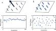
The recent subsidence at Joshimath in the Indian State of Uttarakhand led to the displacement of thousands of residents. Large cracks developed in the buildings and on the ground. No extensive and comprehensive deformation measurement of this event has been made. In this study, we use both PS and PSDS InSAR time series to investigate the magnitude, spatiotemporal as well as kinematic evolution of this slow-moving landslide. Eighty-seven ascending Sentinel-1 scenes with a temporal baseline of 1056 days from 2020 to 2023 were stacked for interferometric analysis. StaMPS is employed to identify PS points by their amplitude and phase information. TomoSAR is utilized to stipulate a coherence matrix to form a dense PSDS network of interferograms to surge point density for suitable phase unwrapping. PS and DS points are coupled to develop slope velocity maps revealing mean displacement rates of –84 mm for PS and –107 mm for PSDS, respectively. Cross-section profiles drawn on the slopes of subsidence show target scatterers on CS1, CS2 and CS4, yield a cumulative displacement of 400 mm in the last 3 years. CS3 and CS5 show a total displacement of about 350 mm. This study applies PSDS time-series InSAR to decipher ground movement in traditionally decohered environments. It also seeks to establish the boundaries and intensity of subsidence to aid in the mitigation of failure progression.
期刊介绍:
The Journal of Earth System Science, an International Journal, was earlier a part of the Proceedings of the Indian Academy of Sciences – Section A begun in 1934, and later split in 1978 into theme journals. This journal was published as Proceedings – Earth and Planetary Sciences since 1978, and in 2005 was renamed ‘Journal of Earth System Science’.
The journal is highly inter-disciplinary and publishes scholarly research – new data, ideas, and conceptual advances – in Earth System Science. The focus is on the evolution of the Earth as a system: manuscripts describing changes of anthropogenic origin in a limited region are not considered unless they go beyond describing the changes to include an analysis of earth-system processes. The journal''s scope includes the solid earth (geosphere), the atmosphere, the hydrosphere (including cryosphere), and the biosphere; it also addresses related aspects of planetary and space sciences. Contributions pertaining to the Indian sub- continent and the surrounding Indian-Ocean region are particularly welcome. Given that a large number of manuscripts report either observations or model results for a limited domain, manuscripts intended for publication in JESS are expected to fulfill at least one of the following three criteria.
The data should be of relevance and should be of statistically significant size and from a region from where such data are sparse. If the data are from a well-sampled region, the data size should be considerable and advance our knowledge of the region.
A model study is carried out to explain observations reported either in the same manuscript or in the literature.
The analysis, whether of data or with models, is novel and the inferences advance the current knowledge.
 求助内容:
求助内容: 应助结果提醒方式:


