{"title":"促进沟壑扩展率的侵蚀驱动因素综合评估--南非近一个世纪的多时空分析","authors":"Debbie Claassen, Greg Botha, Bastien Linol","doi":"10.1002/ldr.5161","DOIUrl":null,"url":null,"abstract":"<p>Rural areas in the Eastern Cape Province of South Africa are severely affected by gully erosion, yet little is known about the rates at which these features are expanding. This study explores the areal extent, physical mechanisms, rates, and drivers of gully expansion with the aim of investigating how erosion rates fluctuate in response to temporal variations of drivers over the last century. Investigations involved the creation of an erosion inventory geo-database, the identification of area-specific physical expansion mechanisms, an assessment of static and dynamic drivers, and a multi-temporal study of 25 gullies in the Mthatha area. Results show gully erosion affects 2.3% of the study area, with gullies exhibiting an average annual areal increase of 2.08%, a sidewall retreat rate of 0.2 m/y, and a headcut retreat of 1.03 m/y over an 82-year period between 1938 and 2020. A multi-temporal case study of the Ngwevana Gully showed average annual areal growth rates ranging from 3.9% between 1938 and 1948 to 0.7% between 2017 and 2020. Findings indicate that although gullies consistently expand their areal footprint, they do so at fluctuating rates. An assessment of erosion drivers reveals that temporal promotion or suppression of these erosion rates occurs in response to the complex and dynamic interactions of both natural mechanisms and anthropogenic activities. In Mthatha, the periods of increased rates of erosion are linked to large-scale flooding events during drier climate cycles, which were further exacerbated by invasive dryland agricultural practices, inappropriate land use, haphazard infrastructure development, and rapid population increases facilitated by past Apartheid settlement laws.</p>","PeriodicalId":203,"journal":{"name":"Land Degradation & Development","volume":null,"pages":null},"PeriodicalIF":3.6000,"publicationDate":"2024-05-09","publicationTypes":"Journal Article","fieldsOfStudy":null,"isOpenAccess":false,"openAccessPdf":"https://onlinelibrary.wiley.com/doi/epdf/10.1002/ldr.5161","citationCount":"0","resultStr":"{\"title\":\"An integrated assessment of erosion drivers facilitating gully expansion rates—A near century multi-temporal analysis from South Africa\",\"authors\":\"Debbie Claassen, Greg Botha, Bastien Linol\",\"doi\":\"10.1002/ldr.5161\",\"DOIUrl\":null,\"url\":null,\"abstract\":\"<p>Rural areas in the Eastern Cape Province of South Africa are severely affected by gully erosion, yet little is known about the rates at which these features are expanding. This study explores the areal extent, physical mechanisms, rates, and drivers of gully expansion with the aim of investigating how erosion rates fluctuate in response to temporal variations of drivers over the last century. Investigations involved the creation of an erosion inventory geo-database, the identification of area-specific physical expansion mechanisms, an assessment of static and dynamic drivers, and a multi-temporal study of 25 gullies in the Mthatha area. Results show gully erosion affects 2.3% of the study area, with gullies exhibiting an average annual areal increase of 2.08%, a sidewall retreat rate of 0.2 m/y, and a headcut retreat of 1.03 m/y over an 82-year period between 1938 and 2020. A multi-temporal case study of the Ngwevana Gully showed average annual areal growth rates ranging from 3.9% between 1938 and 1948 to 0.7% between 2017 and 2020. Findings indicate that although gullies consistently expand their areal footprint, they do so at fluctuating rates. An assessment of erosion drivers reveals that temporal promotion or suppression of these erosion rates occurs in response to the complex and dynamic interactions of both natural mechanisms and anthropogenic activities. In Mthatha, the periods of increased rates of erosion are linked to large-scale flooding events during drier climate cycles, which were further exacerbated by invasive dryland agricultural practices, inappropriate land use, haphazard infrastructure development, and rapid population increases facilitated by past Apartheid settlement laws.</p>\",\"PeriodicalId\":203,\"journal\":{\"name\":\"Land Degradation & Development\",\"volume\":null,\"pages\":null},\"PeriodicalIF\":3.6000,\"publicationDate\":\"2024-05-09\",\"publicationTypes\":\"Journal Article\",\"fieldsOfStudy\":null,\"isOpenAccess\":false,\"openAccessPdf\":\"https://onlinelibrary.wiley.com/doi/epdf/10.1002/ldr.5161\",\"citationCount\":\"0\",\"resultStr\":null,\"platform\":\"Semanticscholar\",\"paperid\":null,\"PeriodicalName\":\"Land Degradation & Development\",\"FirstCategoryId\":\"97\",\"ListUrlMain\":\"https://onlinelibrary.wiley.com/doi/10.1002/ldr.5161\",\"RegionNum\":2,\"RegionCategory\":\"农林科学\",\"ArticlePicture\":[],\"TitleCN\":null,\"AbstractTextCN\":null,\"PMCID\":null,\"EPubDate\":\"\",\"PubModel\":\"\",\"JCR\":\"Q2\",\"JCRName\":\"ENVIRONMENTAL SCIENCES\",\"Score\":null,\"Total\":0}","platform":"Semanticscholar","paperid":null,"PeriodicalName":"Land Degradation & Development","FirstCategoryId":"97","ListUrlMain":"https://onlinelibrary.wiley.com/doi/10.1002/ldr.5161","RegionNum":2,"RegionCategory":"农林科学","ArticlePicture":[],"TitleCN":null,"AbstractTextCN":null,"PMCID":null,"EPubDate":"","PubModel":"","JCR":"Q2","JCRName":"ENVIRONMENTAL SCIENCES","Score":null,"Total":0}
An integrated assessment of erosion drivers facilitating gully expansion rates—A near century multi-temporal analysis from South Africa
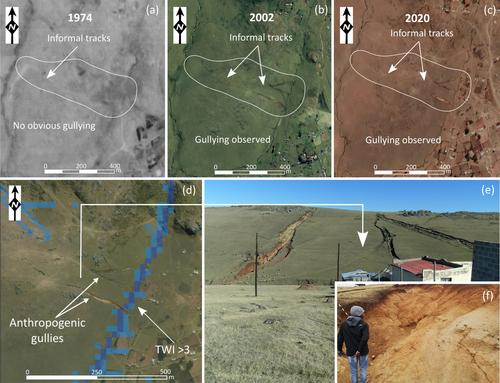
Rural areas in the Eastern Cape Province of South Africa are severely affected by gully erosion, yet little is known about the rates at which these features are expanding. This study explores the areal extent, physical mechanisms, rates, and drivers of gully expansion with the aim of investigating how erosion rates fluctuate in response to temporal variations of drivers over the last century. Investigations involved the creation of an erosion inventory geo-database, the identification of area-specific physical expansion mechanisms, an assessment of static and dynamic drivers, and a multi-temporal study of 25 gullies in the Mthatha area. Results show gully erosion affects 2.3% of the study area, with gullies exhibiting an average annual areal increase of 2.08%, a sidewall retreat rate of 0.2 m/y, and a headcut retreat of 1.03 m/y over an 82-year period between 1938 and 2020. A multi-temporal case study of the Ngwevana Gully showed average annual areal growth rates ranging from 3.9% between 1938 and 1948 to 0.7% between 2017 and 2020. Findings indicate that although gullies consistently expand their areal footprint, they do so at fluctuating rates. An assessment of erosion drivers reveals that temporal promotion or suppression of these erosion rates occurs in response to the complex and dynamic interactions of both natural mechanisms and anthropogenic activities. In Mthatha, the periods of increased rates of erosion are linked to large-scale flooding events during drier climate cycles, which were further exacerbated by invasive dryland agricultural practices, inappropriate land use, haphazard infrastructure development, and rapid population increases facilitated by past Apartheid settlement laws.
期刊介绍:
Land Degradation & Development is an international journal which seeks to promote rational study of the recognition, monitoring, control and rehabilitation of degradation in terrestrial environments. The journal focuses on:
- what land degradation is;
- what causes land degradation;
- the impacts of land degradation
- the scale of land degradation;
- the history, current status or future trends of land degradation;
- avoidance, mitigation and control of land degradation;
- remedial actions to rehabilitate or restore degraded land;
- sustainable land management.

 求助内容:
求助内容: 应助结果提醒方式:


