{"title":"利用地貌指标编制伊朗卡沙夫鲁德盆地洪水区划和洪水风险地图","authors":"Ghasem Panahi, Saeed Reza Khodashenas, Alireza Faridhosseini","doi":"10.1111/jfr3.12981","DOIUrl":null,"url":null,"abstract":"<p>The risk of flooding has become more significant in many parts of the world due to climate change and increased urbanization. Flood has devastating effects on infrastructure, and communities, causing damage to property and loss of life. Simulation of flood extent in a particular area is done by using various mathematical models, hydrologic-hydraulic models, and datasets. Flood modeling using hydraulic-hydrological models has many errors due to the lack of hydraulic-hydrologic data and insufficient statistical period length. This study demonstrates the fact that the geomorphological index (GI) method, which is based on the digital elevation model and requires little hydraulic-hydrologic data, is an effective method for flood modeling. Flood zoning based on GI was performed within the Kashafroud basin with 25, 100, and 200-year return periods by using geomorphic flood area (GFA) plugin in QGIS software. The true positive rates were 0.985, 0.989, and 0.992, respectively, which showed the high accuracy of flood zoning based on the GI method. Here proposed method showed that using the GFA plugin offers a good way for the flood risk assessment in a basin with the lack of measured data as an alternative to the hydraulic-hydrological methods.</p>","PeriodicalId":49294,"journal":{"name":"Journal of Flood Risk Management","volume":"17 2","pages":""},"PeriodicalIF":3.0000,"publicationDate":"2024-03-07","publicationTypes":"Journal Article","fieldsOfStudy":null,"isOpenAccess":false,"openAccessPdf":"https://onlinelibrary.wiley.com/doi/epdf/10.1111/jfr3.12981","citationCount":"0","resultStr":"{\"title\":\"Using geomorphologic indicators in preparation for flood zoning and flood risk maps in the Kashafroud basin, Iran\",\"authors\":\"Ghasem Panahi, Saeed Reza Khodashenas, Alireza Faridhosseini\",\"doi\":\"10.1111/jfr3.12981\",\"DOIUrl\":null,\"url\":null,\"abstract\":\"<p>The risk of flooding has become more significant in many parts of the world due to climate change and increased urbanization. Flood has devastating effects on infrastructure, and communities, causing damage to property and loss of life. Simulation of flood extent in a particular area is done by using various mathematical models, hydrologic-hydraulic models, and datasets. Flood modeling using hydraulic-hydrological models has many errors due to the lack of hydraulic-hydrologic data and insufficient statistical period length. This study demonstrates the fact that the geomorphological index (GI) method, which is based on the digital elevation model and requires little hydraulic-hydrologic data, is an effective method for flood modeling. Flood zoning based on GI was performed within the Kashafroud basin with 25, 100, and 200-year return periods by using geomorphic flood area (GFA) plugin in QGIS software. The true positive rates were 0.985, 0.989, and 0.992, respectively, which showed the high accuracy of flood zoning based on the GI method. Here proposed method showed that using the GFA plugin offers a good way for the flood risk assessment in a basin with the lack of measured data as an alternative to the hydraulic-hydrological methods.</p>\",\"PeriodicalId\":49294,\"journal\":{\"name\":\"Journal of Flood Risk Management\",\"volume\":\"17 2\",\"pages\":\"\"},\"PeriodicalIF\":3.0000,\"publicationDate\":\"2024-03-07\",\"publicationTypes\":\"Journal Article\",\"fieldsOfStudy\":null,\"isOpenAccess\":false,\"openAccessPdf\":\"https://onlinelibrary.wiley.com/doi/epdf/10.1111/jfr3.12981\",\"citationCount\":\"0\",\"resultStr\":null,\"platform\":\"Semanticscholar\",\"paperid\":null,\"PeriodicalName\":\"Journal of Flood Risk Management\",\"FirstCategoryId\":\"93\",\"ListUrlMain\":\"https://onlinelibrary.wiley.com/doi/10.1111/jfr3.12981\",\"RegionNum\":3,\"RegionCategory\":\"环境科学与生态学\",\"ArticlePicture\":[],\"TitleCN\":null,\"AbstractTextCN\":null,\"PMCID\":null,\"EPubDate\":\"\",\"PubModel\":\"\",\"JCR\":\"Q2\",\"JCRName\":\"ENVIRONMENTAL SCIENCES\",\"Score\":null,\"Total\":0}","platform":"Semanticscholar","paperid":null,"PeriodicalName":"Journal of Flood Risk Management","FirstCategoryId":"93","ListUrlMain":"https://onlinelibrary.wiley.com/doi/10.1111/jfr3.12981","RegionNum":3,"RegionCategory":"环境科学与生态学","ArticlePicture":[],"TitleCN":null,"AbstractTextCN":null,"PMCID":null,"EPubDate":"","PubModel":"","JCR":"Q2","JCRName":"ENVIRONMENTAL SCIENCES","Score":null,"Total":0}
引用次数: 0
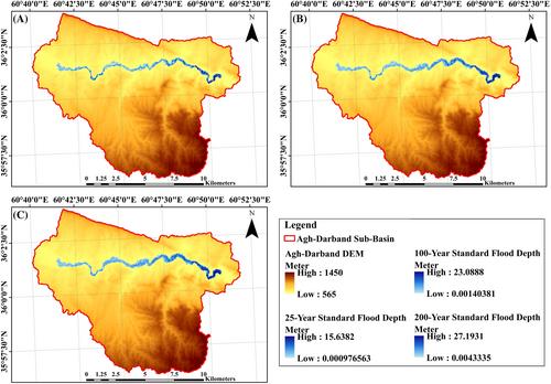
摘要
由于气候变化和城市化的加剧,洪水的风险在世界许多地方都变得更加严重。洪水对基础设施和社区造成破坏性影响,导致财产损失和人员伤亡。使用各种数学模型、水文-水力模型和数据集可以模拟特定地区的洪水范围。由于缺乏水文-水文数据和统计周期长度不足,使用水文-水文模型进行洪水模拟存在许多误差。本研究证明,基于数字高程模型、对水文-水文数据要求不高的地貌指数(GI)方法是一种有效的洪水建模方法。利用 QGIS 软件中的地貌洪水区 (GFA) 插件,在卡沙夫鲁德盆地内对 25、100 和 200 年一遇的洪水进行了基于 GI 的洪水区划。真阳性率分别为 0.985、0.989 和 0.992,这表明基于 GI 方法的洪水区划具有很高的准确性。本文提出的方法表明,在缺乏实测数据的流域,使用 GFA 插件为洪水风险评估提供了一种可替代水力-水文方法的良好途径。
Using geomorphologic indicators in preparation for flood zoning and flood risk maps in the Kashafroud basin, Iran
The risk of flooding has become more significant in many parts of the world due to climate change and increased urbanization. Flood has devastating effects on infrastructure, and communities, causing damage to property and loss of life. Simulation of flood extent in a particular area is done by using various mathematical models, hydrologic-hydraulic models, and datasets. Flood modeling using hydraulic-hydrological models has many errors due to the lack of hydraulic-hydrologic data and insufficient statistical period length. This study demonstrates the fact that the geomorphological index (GI) method, which is based on the digital elevation model and requires little hydraulic-hydrologic data, is an effective method for flood modeling. Flood zoning based on GI was performed within the Kashafroud basin with 25, 100, and 200-year return periods by using geomorphic flood area (GFA) plugin in QGIS software. The true positive rates were 0.985, 0.989, and 0.992, respectively, which showed the high accuracy of flood zoning based on the GI method. Here proposed method showed that using the GFA plugin offers a good way for the flood risk assessment in a basin with the lack of measured data as an alternative to the hydraulic-hydrological methods.
期刊介绍:
Journal of Flood Risk Management provides an international platform for knowledge sharing in all areas related to flood risk. Its explicit aim is to disseminate ideas across the range of disciplines where flood related research is carried out and it provides content ranging from leading edge academic papers to applied content with the practitioner in mind.
Readers and authors come from a wide background and include hydrologists, meteorologists, geographers, geomorphologists, conservationists, civil engineers, social scientists, policy makers, insurers and practitioners. They share an interest in managing the complex interactions between the many skills and disciplines that underpin the management of flood risk across the world.

 求助内容:
求助内容: 应助结果提醒方式:


