Salem-Vall Brahim, Akinade Shadrach Olatunji, Aliyu Ohani Umaru, Olusegun G. Olisa, Sidhmed Sidi Reyoug, Ahmed Hamoud
{"title":"利用大地遥感卫星 8 号绘制毛里塔尼亚北部雷吉巴特地盾东部含铀花岗岩的岩性、结构和蚀变图","authors":"Salem-Vall Brahim, Akinade Shadrach Olatunji, Aliyu Ohani Umaru, Olusegun G. Olisa, Sidhmed Sidi Reyoug, Ahmed Hamoud","doi":"10.1007/s12517-024-11973-w","DOIUrl":null,"url":null,"abstract":"<p>The efficacy of remote sensing techniques for mineral exploration has been proven through several geological investigations. Therefore, this study used remote sensing techniques to delineate uranium prospective zones in the oriental part of Reguibat shield. This region is desert, flat and uncovered by vegetation and presents suitable characteristics for use of satellite images. Radiometric calibration, atmospheric correction, colour composite, principal component analysis (PCA), lineament extraction and band ratios were the main methods performed for the pre-processing and the processing of Landsat 8 OLI images. The findings of the current study revealed lithological units dominated by felsic rocks in association with metasediment, highlighted using band composite (bands 7, 5 and 3, then 7, 2, and 1, in RGB), PCs (PC1, PC2, and PC3) and band ratio (7/5, 5/4, and 6/7 in RGB). The lineament extraction and analysis indicated major deformation trending NNE-SSW affecting geological units of the area. The prospective uraniferous zone delineated showed a spatial distribution in relation with an identified shear zone which suggests a reasonable structural control of the mineralization. The results from this study were validated with existing data from previous map and ground truthing from fieldwork, and they showed high level of agreement. The result of this study further demonstrated the applicability of Landsat 8 OLI as suitable lithological mapping tool in the desert areas. The methodology employed in this research has wide-ranging applications in the identification and delineation of potential uranium-rich regions using remote sensing techniques. For uranium exploration purpose, this approach can be effectively utilized in various other regions to delineate new uraniferous area within the Reguibat shield, as well as in arid and semi-arid areas across the globe.</p>","PeriodicalId":476,"journal":{"name":"Arabian Journal of Geosciences","volume":null,"pages":null},"PeriodicalIF":1.8270,"publicationDate":"2024-05-07","publicationTypes":"Journal Article","fieldsOfStudy":null,"isOpenAccess":false,"openAccessPdf":"","citationCount":"0","resultStr":"{\"title\":\"Lithological, structural, and alteration mapping of uraniferous granitoid using Landsat 8, in the oriental part of the Reguibat shield, northern Mauritania\",\"authors\":\"Salem-Vall Brahim, Akinade Shadrach Olatunji, Aliyu Ohani Umaru, Olusegun G. Olisa, Sidhmed Sidi Reyoug, Ahmed Hamoud\",\"doi\":\"10.1007/s12517-024-11973-w\",\"DOIUrl\":null,\"url\":null,\"abstract\":\"<p>The efficacy of remote sensing techniques for mineral exploration has been proven through several geological investigations. Therefore, this study used remote sensing techniques to delineate uranium prospective zones in the oriental part of Reguibat shield. This region is desert, flat and uncovered by vegetation and presents suitable characteristics for use of satellite images. Radiometric calibration, atmospheric correction, colour composite, principal component analysis (PCA), lineament extraction and band ratios were the main methods performed for the pre-processing and the processing of Landsat 8 OLI images. The findings of the current study revealed lithological units dominated by felsic rocks in association with metasediment, highlighted using band composite (bands 7, 5 and 3, then 7, 2, and 1, in RGB), PCs (PC1, PC2, and PC3) and band ratio (7/5, 5/4, and 6/7 in RGB). The lineament extraction and analysis indicated major deformation trending NNE-SSW affecting geological units of the area. The prospective uraniferous zone delineated showed a spatial distribution in relation with an identified shear zone which suggests a reasonable structural control of the mineralization. The results from this study were validated with existing data from previous map and ground truthing from fieldwork, and they showed high level of agreement. The result of this study further demonstrated the applicability of Landsat 8 OLI as suitable lithological mapping tool in the desert areas. The methodology employed in this research has wide-ranging applications in the identification and delineation of potential uranium-rich regions using remote sensing techniques. For uranium exploration purpose, this approach can be effectively utilized in various other regions to delineate new uraniferous area within the Reguibat shield, as well as in arid and semi-arid areas across the globe.</p>\",\"PeriodicalId\":476,\"journal\":{\"name\":\"Arabian Journal of Geosciences\",\"volume\":null,\"pages\":null},\"PeriodicalIF\":1.8270,\"publicationDate\":\"2024-05-07\",\"publicationTypes\":\"Journal Article\",\"fieldsOfStudy\":null,\"isOpenAccess\":false,\"openAccessPdf\":\"\",\"citationCount\":\"0\",\"resultStr\":null,\"platform\":\"Semanticscholar\",\"paperid\":null,\"PeriodicalName\":\"Arabian Journal of Geosciences\",\"FirstCategoryId\":\"1085\",\"ListUrlMain\":\"https://doi.org/10.1007/s12517-024-11973-w\",\"RegionNum\":0,\"RegionCategory\":null,\"ArticlePicture\":[],\"TitleCN\":null,\"AbstractTextCN\":null,\"PMCID\":null,\"EPubDate\":\"\",\"PubModel\":\"\",\"JCR\":\"Q2\",\"JCRName\":\"Earth and Planetary Sciences\",\"Score\":null,\"Total\":0}","platform":"Semanticscholar","paperid":null,"PeriodicalName":"Arabian Journal of Geosciences","FirstCategoryId":"1085","ListUrlMain":"https://doi.org/10.1007/s12517-024-11973-w","RegionNum":0,"RegionCategory":null,"ArticlePicture":[],"TitleCN":null,"AbstractTextCN":null,"PMCID":null,"EPubDate":"","PubModel":"","JCR":"Q2","JCRName":"Earth and Planetary Sciences","Score":null,"Total":0}
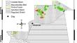
Lithological, structural, and alteration mapping of uraniferous granitoid using Landsat 8, in the oriental part of the Reguibat shield, northern Mauritania
The efficacy of remote sensing techniques for mineral exploration has been proven through several geological investigations. Therefore, this study used remote sensing techniques to delineate uranium prospective zones in the oriental part of Reguibat shield. This region is desert, flat and uncovered by vegetation and presents suitable characteristics for use of satellite images. Radiometric calibration, atmospheric correction, colour composite, principal component analysis (PCA), lineament extraction and band ratios were the main methods performed for the pre-processing and the processing of Landsat 8 OLI images. The findings of the current study revealed lithological units dominated by felsic rocks in association with metasediment, highlighted using band composite (bands 7, 5 and 3, then 7, 2, and 1, in RGB), PCs (PC1, PC2, and PC3) and band ratio (7/5, 5/4, and 6/7 in RGB). The lineament extraction and analysis indicated major deformation trending NNE-SSW affecting geological units of the area. The prospective uraniferous zone delineated showed a spatial distribution in relation with an identified shear zone which suggests a reasonable structural control of the mineralization. The results from this study were validated with existing data from previous map and ground truthing from fieldwork, and they showed high level of agreement. The result of this study further demonstrated the applicability of Landsat 8 OLI as suitable lithological mapping tool in the desert areas. The methodology employed in this research has wide-ranging applications in the identification and delineation of potential uranium-rich regions using remote sensing techniques. For uranium exploration purpose, this approach can be effectively utilized in various other regions to delineate new uraniferous area within the Reguibat shield, as well as in arid and semi-arid areas across the globe.
期刊介绍:
The Arabian Journal of Geosciences is the official journal of the Saudi Society for Geosciences and publishes peer-reviewed original and review articles on the entire range of Earth Science themes, focused on, but not limited to, those that have regional significance to the Middle East and the Euro-Mediterranean Zone.
Key topics therefore include; geology, hydrogeology, earth system science, petroleum sciences, geophysics, seismology and crustal structures, tectonics, sedimentology, palaeontology, metamorphic and igneous petrology, natural hazards, environmental sciences and sustainable development, geoarchaeology, geomorphology, paleo-environment studies, oceanography, atmospheric sciences, GIS and remote sensing, geodesy, mineralogy, volcanology, geochemistry and metallogenesis.

 求助内容:
求助内容: 应助结果提醒方式:


