Wolfgang Alders, Dylan S. Davis, Julia Jong Haines
{"title":"四维考古学:用多时 PlanetScope 卫星数据研究地貌","authors":"Wolfgang Alders, Dylan S. Davis, Julia Jong Haines","doi":"10.1007/s10816-024-09644-x","DOIUrl":null,"url":null,"abstract":"<p>For the last seven years, PlanetScope satellites have started near-daily imaging of parts of the Earth’s surface, making high-density multitemporal, multispectral, 3-m pixel imagery accessible to researchers. Multitemporal satellite data enables landscape archaeologists to examine changes in environmental conditions at time scales ranging from daily to decadal. This kind of temporal resolution can accentuate landscape features on the ground by de-emphasizing non-permanent signatures caused by seasonal or even daily changes in vegetation. We argue that the availability of high spatial and temporal resolution multispectral imagery from Planet Inc. will enable new approaches to studying archaeological visibility in landscapes. While palimpsests are discrete overlapping layers of material accumulation, multitemporal composites capture cyclical and seasonal time and can be used to interpret past landscape histories at multiple scales. To illustrate this perspective, we present three case studies using PlanetScope imagery in tropical environments on the Indian Ocean islands of Madagascar, Mauritius, and Zanzibar.</p>","PeriodicalId":47725,"journal":{"name":"Journal of Archaeological Method and Theory","volume":"30 1","pages":""},"PeriodicalIF":2.8000,"publicationDate":"2024-05-03","publicationTypes":"Journal Article","fieldsOfStudy":null,"isOpenAccess":false,"openAccessPdf":"","citationCount":"0","resultStr":"{\"title\":\"Archaeology in the Fourth Dimension: Studying Landscapes with Multitemporal PlanetScope Satellite Data\",\"authors\":\"Wolfgang Alders, Dylan S. Davis, Julia Jong Haines\",\"doi\":\"10.1007/s10816-024-09644-x\",\"DOIUrl\":null,\"url\":null,\"abstract\":\"<p>For the last seven years, PlanetScope satellites have started near-daily imaging of parts of the Earth’s surface, making high-density multitemporal, multispectral, 3-m pixel imagery accessible to researchers. Multitemporal satellite data enables landscape archaeologists to examine changes in environmental conditions at time scales ranging from daily to decadal. This kind of temporal resolution can accentuate landscape features on the ground by de-emphasizing non-permanent signatures caused by seasonal or even daily changes in vegetation. We argue that the availability of high spatial and temporal resolution multispectral imagery from Planet Inc. will enable new approaches to studying archaeological visibility in landscapes. While palimpsests are discrete overlapping layers of material accumulation, multitemporal composites capture cyclical and seasonal time and can be used to interpret past landscape histories at multiple scales. To illustrate this perspective, we present three case studies using PlanetScope imagery in tropical environments on the Indian Ocean islands of Madagascar, Mauritius, and Zanzibar.</p>\",\"PeriodicalId\":47725,\"journal\":{\"name\":\"Journal of Archaeological Method and Theory\",\"volume\":\"30 1\",\"pages\":\"\"},\"PeriodicalIF\":2.8000,\"publicationDate\":\"2024-05-03\",\"publicationTypes\":\"Journal Article\",\"fieldsOfStudy\":null,\"isOpenAccess\":false,\"openAccessPdf\":\"\",\"citationCount\":\"0\",\"resultStr\":null,\"platform\":\"Semanticscholar\",\"paperid\":null,\"PeriodicalName\":\"Journal of Archaeological Method and Theory\",\"FirstCategoryId\":\"98\",\"ListUrlMain\":\"https://doi.org/10.1007/s10816-024-09644-x\",\"RegionNum\":1,\"RegionCategory\":\"历史学\",\"ArticlePicture\":[],\"TitleCN\":null,\"AbstractTextCN\":null,\"PMCID\":null,\"EPubDate\":\"\",\"PubModel\":\"\",\"JCR\":\"Q1\",\"JCRName\":\"ANTHROPOLOGY\",\"Score\":null,\"Total\":0}","platform":"Semanticscholar","paperid":null,"PeriodicalName":"Journal of Archaeological Method and Theory","FirstCategoryId":"98","ListUrlMain":"https://doi.org/10.1007/s10816-024-09644-x","RegionNum":1,"RegionCategory":"历史学","ArticlePicture":[],"TitleCN":null,"AbstractTextCN":null,"PMCID":null,"EPubDate":"","PubModel":"","JCR":"Q1","JCRName":"ANTHROPOLOGY","Score":null,"Total":0}
Archaeology in the Fourth Dimension: Studying Landscapes with Multitemporal PlanetScope Satellite Data
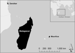
For the last seven years, PlanetScope satellites have started near-daily imaging of parts of the Earth’s surface, making high-density multitemporal, multispectral, 3-m pixel imagery accessible to researchers. Multitemporal satellite data enables landscape archaeologists to examine changes in environmental conditions at time scales ranging from daily to decadal. This kind of temporal resolution can accentuate landscape features on the ground by de-emphasizing non-permanent signatures caused by seasonal or even daily changes in vegetation. We argue that the availability of high spatial and temporal resolution multispectral imagery from Planet Inc. will enable new approaches to studying archaeological visibility in landscapes. While palimpsests are discrete overlapping layers of material accumulation, multitemporal composites capture cyclical and seasonal time and can be used to interpret past landscape histories at multiple scales. To illustrate this perspective, we present three case studies using PlanetScope imagery in tropical environments on the Indian Ocean islands of Madagascar, Mauritius, and Zanzibar.
期刊介绍:
The Journal of Archaeological Method and Theory, the leading journal in its field, presents original articles that address method- or theory-focused issues of current archaeological interest and represent significant explorations on the cutting edge of the discipline. The journal also welcomes topical syntheses that critically assess and integrate research on a specific subject in archaeological method or theory, as well as examinations of the history of archaeology. Written by experts, the articles benefit an international audience of archaeologists, students of archaeology, and practitioners of closely related disciplines. Specific topics covered in recent issues include: the use of nitche construction theory in archaeology, new developments in the use of soil chemistry in archaeological interpretation, and a model for the prehistoric development of clothing. The Journal''s distinguished Editorial Board includes archaeologists with worldwide archaeological knowledge (the Americas, Asia and the Pacific, Europe, and Africa), and expertise in a wide range of methodological and theoretical issues. Rated ''A'' in the European Reference Index for the Humanities (ERIH) Journal of Archaeological Method and Theory is rated ''A'' in the ERIH, a new reference index that aims to help evenly access the scientific quality of Humanities research output. For more information visit: http://www.esf.org/research-areas/humanities/activities/research-infrastructures.html Rated ''A'' in the Australian Research Council Humanities and Creative Arts Journal List. For more information, visit: http://www.arc.gov.au/era/journal_list_dev.htm
 求助内容:
求助内容: 应助结果提醒方式:


