Mohammad Abboud, Yehia Taher, Karine Zeitouni, Ana-Maria Olteanu-Raimond
{"title":"机会性移动监测如何加强空气质量评估?","authors":"Mohammad Abboud, Yehia Taher, Karine Zeitouni, Ana-Maria Olteanu-Raimond","doi":"10.1007/s10707-024-00516-w","DOIUrl":null,"url":null,"abstract":"<p>The deteriorating air quality in urban areas, particularly in developing countries, has led to increased attention being paid to the issue. Daily reports of air pollution are essential to effectively manage public health risks. Pollution estimation has become crucial to expanding spatial and temporal coverage and estimating pollution levels at different locations. The emergence of low-cost sensors has enabled high-resolution data collection, either in fixed or mobile settings, and various approaches have been proposed to estimate air pollution using this technology. The objective of this study is to enhance the data from fixed stations by incorporating opportunistic mobile monitoring (OMM) data. The main research question we are dealing with is: How can we augment fixed station data through OMM? In order to address the challenge of limited OMM data availability, we leverage existing data collected during periods when the pollution maps align with those observed by the fixed stations. By combining the fixed and mobile data, we apply interpolation techniques to produce more accurate pollution maps. The efficacy of our approach is validated through experiments conducted on a real-life dataset.</p>","PeriodicalId":55109,"journal":{"name":"Geoinformatica","volume":"91 1","pages":""},"PeriodicalIF":2.6000,"publicationDate":"2024-04-29","publicationTypes":"Journal Article","fieldsOfStudy":null,"isOpenAccess":false,"openAccessPdf":"","citationCount":"0","resultStr":"{\"title\":\"How opportunistic mobile monitoring can enhance air quality assessment?\",\"authors\":\"Mohammad Abboud, Yehia Taher, Karine Zeitouni, Ana-Maria Olteanu-Raimond\",\"doi\":\"10.1007/s10707-024-00516-w\",\"DOIUrl\":null,\"url\":null,\"abstract\":\"<p>The deteriorating air quality in urban areas, particularly in developing countries, has led to increased attention being paid to the issue. Daily reports of air pollution are essential to effectively manage public health risks. Pollution estimation has become crucial to expanding spatial and temporal coverage and estimating pollution levels at different locations. The emergence of low-cost sensors has enabled high-resolution data collection, either in fixed or mobile settings, and various approaches have been proposed to estimate air pollution using this technology. The objective of this study is to enhance the data from fixed stations by incorporating opportunistic mobile monitoring (OMM) data. The main research question we are dealing with is: How can we augment fixed station data through OMM? In order to address the challenge of limited OMM data availability, we leverage existing data collected during periods when the pollution maps align with those observed by the fixed stations. By combining the fixed and mobile data, we apply interpolation techniques to produce more accurate pollution maps. The efficacy of our approach is validated through experiments conducted on a real-life dataset.</p>\",\"PeriodicalId\":55109,\"journal\":{\"name\":\"Geoinformatica\",\"volume\":\"91 1\",\"pages\":\"\"},\"PeriodicalIF\":2.6000,\"publicationDate\":\"2024-04-29\",\"publicationTypes\":\"Journal Article\",\"fieldsOfStudy\":null,\"isOpenAccess\":false,\"openAccessPdf\":\"\",\"citationCount\":\"0\",\"resultStr\":null,\"platform\":\"Semanticscholar\",\"paperid\":null,\"PeriodicalName\":\"Geoinformatica\",\"FirstCategoryId\":\"94\",\"ListUrlMain\":\"https://doi.org/10.1007/s10707-024-00516-w\",\"RegionNum\":4,\"RegionCategory\":\"计算机科学\",\"ArticlePicture\":[],\"TitleCN\":null,\"AbstractTextCN\":null,\"PMCID\":null,\"EPubDate\":\"\",\"PubModel\":\"\",\"JCR\":\"Q3\",\"JCRName\":\"COMPUTER SCIENCE, INFORMATION SYSTEMS\",\"Score\":null,\"Total\":0}","platform":"Semanticscholar","paperid":null,"PeriodicalName":"Geoinformatica","FirstCategoryId":"94","ListUrlMain":"https://doi.org/10.1007/s10707-024-00516-w","RegionNum":4,"RegionCategory":"计算机科学","ArticlePicture":[],"TitleCN":null,"AbstractTextCN":null,"PMCID":null,"EPubDate":"","PubModel":"","JCR":"Q3","JCRName":"COMPUTER SCIENCE, INFORMATION SYSTEMS","Score":null,"Total":0}
How opportunistic mobile monitoring can enhance air quality assessment?
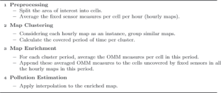
The deteriorating air quality in urban areas, particularly in developing countries, has led to increased attention being paid to the issue. Daily reports of air pollution are essential to effectively manage public health risks. Pollution estimation has become crucial to expanding spatial and temporal coverage and estimating pollution levels at different locations. The emergence of low-cost sensors has enabled high-resolution data collection, either in fixed or mobile settings, and various approaches have been proposed to estimate air pollution using this technology. The objective of this study is to enhance the data from fixed stations by incorporating opportunistic mobile monitoring (OMM) data. The main research question we are dealing with is: How can we augment fixed station data through OMM? In order to address the challenge of limited OMM data availability, we leverage existing data collected during periods when the pollution maps align with those observed by the fixed stations. By combining the fixed and mobile data, we apply interpolation techniques to produce more accurate pollution maps. The efficacy of our approach is validated through experiments conducted on a real-life dataset.
期刊介绍:
GeoInformatica is located at the confluence of two rapidly advancing domains: Computer Science and Geographic Information Science; nowadays, Earth studies use more and more sophisticated computing theory and tools, and computer processing of Earth observations through Geographic Information Systems (GIS) attracts a great deal of attention from governmental, industrial and research worlds.
This journal aims to promote the most innovative results coming from the research in the field of computer science applied to geographic information systems. Thus, GeoInformatica provides an effective forum for disseminating original and fundamental research and experience in the rapidly advancing area of the use of computer science for spatial studies.
 求助内容:
求助内容: 应助结果提醒方式:


