Abreham Birhane Kassay, Abraham Woldemichael Tuhar, Mihret Dananto Ulsido
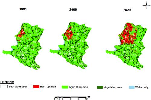
{"title":"埃塞俄比亚哈瓦萨湖流域发展中城市的土地覆被动态和城市扩张对雨水管理响应的敏感性分析","authors":"Abreham Birhane Kassay, Abraham Woldemichael Tuhar, Mihret Dananto Ulsido","doi":"10.1111/jfr3.12994","DOIUrl":null,"url":null,"abstract":"<p>Hawassa is a rapidly developing city in Lake Hawassa watershed of Ethiopia. Analyzing the effect of land cover dynamics on surface runoff remains imperative to adaptive urban stormwater management. This study quantified spatial variation of land cover and sensitivity of stormwater management response. Historical 30 years of daily annual rainfall, three satellite imageries, DEM, and hydrological soil group data were analyzed. A statistical-based combined approach of geospatial techniques and Soil Conservation Service-Curve Number (SCS-CN) model was employed. CN and surface runoff depth for the delineated urban watersheds were determined. The result revealed that the built-up area increased by 30.9 km<sup>2</sup>, where the rate varies spatially. The variation of impervious land cover explains 58.6% of change in CN with coefficient of 0.352. While CN is inversely correlated with agricultural and vegetation land cover variations. The finding suggests CN explains 96.78% of the change in surface runoff with a significant correlation coefficient of 3.91. The proposed integrated model approach justifies the potential to reorganize the relationship between the spatial effect of land cover variation on surface runoff at the urban watersheds. Thus, suitable local-specific solutions can be devised for effective management of flood risk and optimize the drainage system of urban areas.</p>","PeriodicalId":49294,"journal":{"name":"Journal of Flood Risk Management","volume":"17 3","pages":""},"PeriodicalIF":3.0000,"publicationDate":"2024-04-13","publicationTypes":"Journal Article","fieldsOfStudy":null,"isOpenAccess":false,"openAccessPdf":"https://onlinelibrary.wiley.com/doi/epdf/10.1111/jfr3.12994","citationCount":"0","resultStr":"{\"title\":\"Sensitivity analysis on stormwater management response to land cover dynamics and urban expansion of developing City in Lake Hawassa watershed, Ethiopia\",\"authors\":\"Abreham Birhane Kassay, Abraham Woldemichael Tuhar, Mihret Dananto Ulsido\",\"doi\":\"10.1111/jfr3.12994\",\"DOIUrl\":null,\"url\":null,\"abstract\":\"<p>Hawassa is a rapidly developing city in Lake Hawassa watershed of Ethiopia. Analyzing the effect of land cover dynamics on surface runoff remains imperative to adaptive urban stormwater management. This study quantified spatial variation of land cover and sensitivity of stormwater management response. Historical 30 years of daily annual rainfall, three satellite imageries, DEM, and hydrological soil group data were analyzed. A statistical-based combined approach of geospatial techniques and Soil Conservation Service-Curve Number (SCS-CN) model was employed. CN and surface runoff depth for the delineated urban watersheds were determined. The result revealed that the built-up area increased by 30.9 km<sup>2</sup>, where the rate varies spatially. The variation of impervious land cover explains 58.6% of change in CN with coefficient of 0.352. While CN is inversely correlated with agricultural and vegetation land cover variations. The finding suggests CN explains 96.78% of the change in surface runoff with a significant correlation coefficient of 3.91. The proposed integrated model approach justifies the potential to reorganize the relationship between the spatial effect of land cover variation on surface runoff at the urban watersheds. Thus, suitable local-specific solutions can be devised for effective management of flood risk and optimize the drainage system of urban areas.</p>\",\"PeriodicalId\":49294,\"journal\":{\"name\":\"Journal of Flood Risk Management\",\"volume\":\"17 3\",\"pages\":\"\"},\"PeriodicalIF\":3.0000,\"publicationDate\":\"2024-04-13\",\"publicationTypes\":\"Journal Article\",\"fieldsOfStudy\":null,\"isOpenAccess\":false,\"openAccessPdf\":\"https://onlinelibrary.wiley.com/doi/epdf/10.1111/jfr3.12994\",\"citationCount\":\"0\",\"resultStr\":null,\"platform\":\"Semanticscholar\",\"paperid\":null,\"PeriodicalName\":\"Journal of Flood Risk Management\",\"FirstCategoryId\":\"93\",\"ListUrlMain\":\"https://onlinelibrary.wiley.com/doi/10.1111/jfr3.12994\",\"RegionNum\":3,\"RegionCategory\":\"环境科学与生态学\",\"ArticlePicture\":[],\"TitleCN\":null,\"AbstractTextCN\":null,\"PMCID\":null,\"EPubDate\":\"\",\"PubModel\":\"\",\"JCR\":\"Q2\",\"JCRName\":\"ENVIRONMENTAL SCIENCES\",\"Score\":null,\"Total\":0}","platform":"Semanticscholar","paperid":null,"PeriodicalName":"Journal of Flood Risk Management","FirstCategoryId":"93","ListUrlMain":"https://onlinelibrary.wiley.com/doi/10.1111/jfr3.12994","RegionNum":3,"RegionCategory":"环境科学与生态学","ArticlePicture":[],"TitleCN":null,"AbstractTextCN":null,"PMCID":null,"EPubDate":"","PubModel":"","JCR":"Q2","JCRName":"ENVIRONMENTAL SCIENCES","Score":null,"Total":0}
Sensitivity analysis on stormwater management response to land cover dynamics and urban expansion of developing City in Lake Hawassa watershed, Ethiopia
Hawassa is a rapidly developing city in Lake Hawassa watershed of Ethiopia. Analyzing the effect of land cover dynamics on surface runoff remains imperative to adaptive urban stormwater management. This study quantified spatial variation of land cover and sensitivity of stormwater management response. Historical 30 years of daily annual rainfall, three satellite imageries, DEM, and hydrological soil group data were analyzed. A statistical-based combined approach of geospatial techniques and Soil Conservation Service-Curve Number (SCS-CN) model was employed. CN and surface runoff depth for the delineated urban watersheds were determined. The result revealed that the built-up area increased by 30.9 km2, where the rate varies spatially. The variation of impervious land cover explains 58.6% of change in CN with coefficient of 0.352. While CN is inversely correlated with agricultural and vegetation land cover variations. The finding suggests CN explains 96.78% of the change in surface runoff with a significant correlation coefficient of 3.91. The proposed integrated model approach justifies the potential to reorganize the relationship between the spatial effect of land cover variation on surface runoff at the urban watersheds. Thus, suitable local-specific solutions can be devised for effective management of flood risk and optimize the drainage system of urban areas.
期刊介绍:
Journal of Flood Risk Management provides an international platform for knowledge sharing in all areas related to flood risk. Its explicit aim is to disseminate ideas across the range of disciplines where flood related research is carried out and it provides content ranging from leading edge academic papers to applied content with the practitioner in mind.
Readers and authors come from a wide background and include hydrologists, meteorologists, geographers, geomorphologists, conservationists, civil engineers, social scientists, policy makers, insurers and practitioners. They share an interest in managing the complex interactions between the many skills and disciplines that underpin the management of flood risk across the world.

 求助内容:
求助内容: 应助结果提醒方式:


