{"title":"利用地理空间数据以及 RUSLE 模型和地理信息系统的综合方法评估突尼斯东北部的土壤侵蚀风险","authors":"Sinda Sifi, Abdelwaheb Aydi, Asma Bouamrane, Sabrine Zaghdoudi, Mohamed Gasmi","doi":"10.1007/s12040-024-02283-6","DOIUrl":null,"url":null,"abstract":"<p>Assessing the spatial distribution of the erosion process is considered a critical initial step to provide valuable insights to decision-makers for devising an effective erosion mitigation strategy to reduce erosion damages. This research was conducted based on a revised universal soil loss equation (RUSLE) model integrated with the geographic information environment (GIS) within the Wadi El Ghareg watershed located in the Menzel Bourguiba region in northeastern Tunisia to simulate the spatial distribution of erosion across the basin which has been experiencing adverse effects of climate change, characterized by periods of drought and heavy rainfall. The RUSLE incorporates several variables, including rainfall erosivity (<i>R</i>), soil erodibility (<i>K</i>), cover management (<i>C</i>), slope length (<i>LS</i>), and conservation practices (<i>P</i>), serving as key predisposition parameters in this research. For the validation process of the applied model, 200 points were selected to create an inventory map; the points were selected based on satellite images and field surveys. The obtained thematic maps were normalized by fuzzy logic and overlaid using the model equation in the GIS. The results identified the most severely eroded areas requiring immediate erosion control measures. Hence, the results reveal that about 1.71% of the area is covered under severe erosion risk, 0.13% area under high erosion risk, 0.26% area under moderate erosion risk, 0.27% area under low erosion risk, and 97.63% of the area under very low erosion risk. The accuracy of the model was evaluated based on the receiver operating characteristic curves (ROC) and the areas under the curves (AUC). The result showed that this model had an excellent predictive accuracy for soil erosion susceptibility, with AUC values of 0.967. The final produced map will be used as a basis for suggesting a framework that can help make practical policy recommendations to fight against erosion in the context of sustainable management of the watershed.</p>","PeriodicalId":15609,"journal":{"name":"Journal of Earth System Science","volume":null,"pages":null},"PeriodicalIF":1.3000,"publicationDate":"2024-04-04","publicationTypes":"Journal Article","fieldsOfStudy":null,"isOpenAccess":false,"openAccessPdf":"","citationCount":"0","resultStr":"{\"title\":\"Appraisal of soil erosion risk in northeastern Tunisia using geospatial data and integrated approach of RUSLE model and GIS\",\"authors\":\"Sinda Sifi, Abdelwaheb Aydi, Asma Bouamrane, Sabrine Zaghdoudi, Mohamed Gasmi\",\"doi\":\"10.1007/s12040-024-02283-6\",\"DOIUrl\":null,\"url\":null,\"abstract\":\"<p>Assessing the spatial distribution of the erosion process is considered a critical initial step to provide valuable insights to decision-makers for devising an effective erosion mitigation strategy to reduce erosion damages. This research was conducted based on a revised universal soil loss equation (RUSLE) model integrated with the geographic information environment (GIS) within the Wadi El Ghareg watershed located in the Menzel Bourguiba region in northeastern Tunisia to simulate the spatial distribution of erosion across the basin which has been experiencing adverse effects of climate change, characterized by periods of drought and heavy rainfall. The RUSLE incorporates several variables, including rainfall erosivity (<i>R</i>), soil erodibility (<i>K</i>), cover management (<i>C</i>), slope length (<i>LS</i>), and conservation practices (<i>P</i>), serving as key predisposition parameters in this research. For the validation process of the applied model, 200 points were selected to create an inventory map; the points were selected based on satellite images and field surveys. The obtained thematic maps were normalized by fuzzy logic and overlaid using the model equation in the GIS. The results identified the most severely eroded areas requiring immediate erosion control measures. Hence, the results reveal that about 1.71% of the area is covered under severe erosion risk, 0.13% area under high erosion risk, 0.26% area under moderate erosion risk, 0.27% area under low erosion risk, and 97.63% of the area under very low erosion risk. The accuracy of the model was evaluated based on the receiver operating characteristic curves (ROC) and the areas under the curves (AUC). The result showed that this model had an excellent predictive accuracy for soil erosion susceptibility, with AUC values of 0.967. The final produced map will be used as a basis for suggesting a framework that can help make practical policy recommendations to fight against erosion in the context of sustainable management of the watershed.</p>\",\"PeriodicalId\":15609,\"journal\":{\"name\":\"Journal of Earth System Science\",\"volume\":null,\"pages\":null},\"PeriodicalIF\":1.3000,\"publicationDate\":\"2024-04-04\",\"publicationTypes\":\"Journal Article\",\"fieldsOfStudy\":null,\"isOpenAccess\":false,\"openAccessPdf\":\"\",\"citationCount\":\"0\",\"resultStr\":null,\"platform\":\"Semanticscholar\",\"paperid\":null,\"PeriodicalName\":\"Journal of Earth System Science\",\"FirstCategoryId\":\"89\",\"ListUrlMain\":\"https://doi.org/10.1007/s12040-024-02283-6\",\"RegionNum\":4,\"RegionCategory\":\"地球科学\",\"ArticlePicture\":[],\"TitleCN\":null,\"AbstractTextCN\":null,\"PMCID\":null,\"EPubDate\":\"\",\"PubModel\":\"\",\"JCR\":\"Q3\",\"JCRName\":\"GEOSCIENCES, MULTIDISCIPLINARY\",\"Score\":null,\"Total\":0}","platform":"Semanticscholar","paperid":null,"PeriodicalName":"Journal of Earth System Science","FirstCategoryId":"89","ListUrlMain":"https://doi.org/10.1007/s12040-024-02283-6","RegionNum":4,"RegionCategory":"地球科学","ArticlePicture":[],"TitleCN":null,"AbstractTextCN":null,"PMCID":null,"EPubDate":"","PubModel":"","JCR":"Q3","JCRName":"GEOSCIENCES, MULTIDISCIPLINARY","Score":null,"Total":0}
Appraisal of soil erosion risk in northeastern Tunisia using geospatial data and integrated approach of RUSLE model and GIS
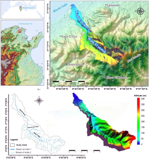
Assessing the spatial distribution of the erosion process is considered a critical initial step to provide valuable insights to decision-makers for devising an effective erosion mitigation strategy to reduce erosion damages. This research was conducted based on a revised universal soil loss equation (RUSLE) model integrated with the geographic information environment (GIS) within the Wadi El Ghareg watershed located in the Menzel Bourguiba region in northeastern Tunisia to simulate the spatial distribution of erosion across the basin which has been experiencing adverse effects of climate change, characterized by periods of drought and heavy rainfall. The RUSLE incorporates several variables, including rainfall erosivity (R), soil erodibility (K), cover management (C), slope length (LS), and conservation practices (P), serving as key predisposition parameters in this research. For the validation process of the applied model, 200 points were selected to create an inventory map; the points were selected based on satellite images and field surveys. The obtained thematic maps were normalized by fuzzy logic and overlaid using the model equation in the GIS. The results identified the most severely eroded areas requiring immediate erosion control measures. Hence, the results reveal that about 1.71% of the area is covered under severe erosion risk, 0.13% area under high erosion risk, 0.26% area under moderate erosion risk, 0.27% area under low erosion risk, and 97.63% of the area under very low erosion risk. The accuracy of the model was evaluated based on the receiver operating characteristic curves (ROC) and the areas under the curves (AUC). The result showed that this model had an excellent predictive accuracy for soil erosion susceptibility, with AUC values of 0.967. The final produced map will be used as a basis for suggesting a framework that can help make practical policy recommendations to fight against erosion in the context of sustainable management of the watershed.
期刊介绍:
The Journal of Earth System Science, an International Journal, was earlier a part of the Proceedings of the Indian Academy of Sciences – Section A begun in 1934, and later split in 1978 into theme journals. This journal was published as Proceedings – Earth and Planetary Sciences since 1978, and in 2005 was renamed ‘Journal of Earth System Science’.
The journal is highly inter-disciplinary and publishes scholarly research – new data, ideas, and conceptual advances – in Earth System Science. The focus is on the evolution of the Earth as a system: manuscripts describing changes of anthropogenic origin in a limited region are not considered unless they go beyond describing the changes to include an analysis of earth-system processes. The journal''s scope includes the solid earth (geosphere), the atmosphere, the hydrosphere (including cryosphere), and the biosphere; it also addresses related aspects of planetary and space sciences. Contributions pertaining to the Indian sub- continent and the surrounding Indian-Ocean region are particularly welcome. Given that a large number of manuscripts report either observations or model results for a limited domain, manuscripts intended for publication in JESS are expected to fulfill at least one of the following three criteria.
The data should be of relevance and should be of statistically significant size and from a region from where such data are sparse. If the data are from a well-sampled region, the data size should be considerable and advance our knowledge of the region.
A model study is carried out to explain observations reported either in the same manuscript or in the literature.
The analysis, whether of data or with models, is novel and the inferences advance the current knowledge.
 求助内容:
求助内容: 应助结果提醒方式:


