{"title":"利用边际熵和互信息为洪水风险评估选择代表性指标","authors":"Hongjun Joo, Wonyoung Choi, Chansoo Jeon","doi":"10.1111/jfr3.12976","DOIUrl":null,"url":null,"abstract":"<p>Floods are the most frequent types of natural disasters. From the perspective of disaster management, indicators associated with floods are important for accurate flood risk assessment. However, the application of all indicators related to flood risk assessment decreases the evaluation efficiency, because the definitions of the indicators may overlap. Moreover, the volume of data required for collection and evaluation is significantly large, making the evaluation practically impossible. Thus, a scientific and objective method to select indicators for flood risk assessment based on the entropy theory was developed herein. First, the existing 28 assessment indicators were analyzed and probability-based data were constructed for each indicator considering 28 districts in a midwestern region of Korea. The information quantity for each indicator was then obtained using marginal entropy and mutual information generated in the entropy theory. Next, the total information quantity based on the numbers of combination of indicators was derived by considering the information quantity for each indicator and the overlapping mutual information between the indicators. The maximum amount of information (161.55) was obtained by combining 18 out of the 28 flood risk indicators. The selected 18 indicators reflected regional characteristics better than those used in the existing method, demonstrating that the flood risk of the target area could be adequately assessed.</p>","PeriodicalId":49294,"journal":{"name":"Journal of Flood Risk Management","volume":"17 2","pages":""},"PeriodicalIF":3.0000,"publicationDate":"2024-02-23","publicationTypes":"Journal Article","fieldsOfStudy":null,"isOpenAccess":false,"openAccessPdf":"https://onlinelibrary.wiley.com/doi/epdf/10.1111/jfr3.12976","citationCount":"0","resultStr":"{\"title\":\"Selection of representative indicators for flood risk assessment using marginal entropy and mutual information\",\"authors\":\"Hongjun Joo, Wonyoung Choi, Chansoo Jeon\",\"doi\":\"10.1111/jfr3.12976\",\"DOIUrl\":null,\"url\":null,\"abstract\":\"<p>Floods are the most frequent types of natural disasters. From the perspective of disaster management, indicators associated with floods are important for accurate flood risk assessment. However, the application of all indicators related to flood risk assessment decreases the evaluation efficiency, because the definitions of the indicators may overlap. Moreover, the volume of data required for collection and evaluation is significantly large, making the evaluation practically impossible. Thus, a scientific and objective method to select indicators for flood risk assessment based on the entropy theory was developed herein. First, the existing 28 assessment indicators were analyzed and probability-based data were constructed for each indicator considering 28 districts in a midwestern region of Korea. The information quantity for each indicator was then obtained using marginal entropy and mutual information generated in the entropy theory. Next, the total information quantity based on the numbers of combination of indicators was derived by considering the information quantity for each indicator and the overlapping mutual information between the indicators. The maximum amount of information (161.55) was obtained by combining 18 out of the 28 flood risk indicators. The selected 18 indicators reflected regional characteristics better than those used in the existing method, demonstrating that the flood risk of the target area could be adequately assessed.</p>\",\"PeriodicalId\":49294,\"journal\":{\"name\":\"Journal of Flood Risk Management\",\"volume\":\"17 2\",\"pages\":\"\"},\"PeriodicalIF\":3.0000,\"publicationDate\":\"2024-02-23\",\"publicationTypes\":\"Journal Article\",\"fieldsOfStudy\":null,\"isOpenAccess\":false,\"openAccessPdf\":\"https://onlinelibrary.wiley.com/doi/epdf/10.1111/jfr3.12976\",\"citationCount\":\"0\",\"resultStr\":null,\"platform\":\"Semanticscholar\",\"paperid\":null,\"PeriodicalName\":\"Journal of Flood Risk Management\",\"FirstCategoryId\":\"93\",\"ListUrlMain\":\"https://onlinelibrary.wiley.com/doi/10.1111/jfr3.12976\",\"RegionNum\":3,\"RegionCategory\":\"环境科学与生态学\",\"ArticlePicture\":[],\"TitleCN\":null,\"AbstractTextCN\":null,\"PMCID\":null,\"EPubDate\":\"\",\"PubModel\":\"\",\"JCR\":\"Q2\",\"JCRName\":\"ENVIRONMENTAL SCIENCES\",\"Score\":null,\"Total\":0}","platform":"Semanticscholar","paperid":null,"PeriodicalName":"Journal of Flood Risk Management","FirstCategoryId":"93","ListUrlMain":"https://onlinelibrary.wiley.com/doi/10.1111/jfr3.12976","RegionNum":3,"RegionCategory":"环境科学与生态学","ArticlePicture":[],"TitleCN":null,"AbstractTextCN":null,"PMCID":null,"EPubDate":"","PubModel":"","JCR":"Q2","JCRName":"ENVIRONMENTAL SCIENCES","Score":null,"Total":0}
Selection of representative indicators for flood risk assessment using marginal entropy and mutual information
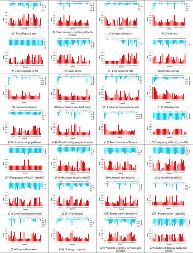
Floods are the most frequent types of natural disasters. From the perspective of disaster management, indicators associated with floods are important for accurate flood risk assessment. However, the application of all indicators related to flood risk assessment decreases the evaluation efficiency, because the definitions of the indicators may overlap. Moreover, the volume of data required for collection and evaluation is significantly large, making the evaluation practically impossible. Thus, a scientific and objective method to select indicators for flood risk assessment based on the entropy theory was developed herein. First, the existing 28 assessment indicators were analyzed and probability-based data were constructed for each indicator considering 28 districts in a midwestern region of Korea. The information quantity for each indicator was then obtained using marginal entropy and mutual information generated in the entropy theory. Next, the total information quantity based on the numbers of combination of indicators was derived by considering the information quantity for each indicator and the overlapping mutual information between the indicators. The maximum amount of information (161.55) was obtained by combining 18 out of the 28 flood risk indicators. The selected 18 indicators reflected regional characteristics better than those used in the existing method, demonstrating that the flood risk of the target area could be adequately assessed.
期刊介绍:
Journal of Flood Risk Management provides an international platform for knowledge sharing in all areas related to flood risk. Its explicit aim is to disseminate ideas across the range of disciplines where flood related research is carried out and it provides content ranging from leading edge academic papers to applied content with the practitioner in mind.
Readers and authors come from a wide background and include hydrologists, meteorologists, geographers, geomorphologists, conservationists, civil engineers, social scientists, policy makers, insurers and practitioners. They share an interest in managing the complex interactions between the many skills and disciplines that underpin the management of flood risk across the world.

 求助内容:
求助内容: 应助结果提醒方式:


