Nafiseh Ghasemian Sorboni, Jinfei Wang, Mohammad Reza Najafi
{"title":"利用深度学习和谷歌街景自动估算首层高度,进行洪水脆弱性分析","authors":"Nafiseh Ghasemian Sorboni, Jinfei Wang, Mohammad Reza Najafi","doi":"10.1111/jfr3.12975","DOIUrl":null,"url":null,"abstract":"<p>Flood events can cause extensive damage to physical infrastructure, pose risks to human life, and necessitate the reoccupation and rehabilitation of affected areas. A key parameter for flood vulnerability assessment is the first floor height (FFH), which also plays an important role in setting insurance premiums. Traditional methods for FFH estimation rely on ground surveys and site inspections, yet these approaches are both time-consuming and labor-intensive. In this study, we propose an alternative approach based on measurements derived from Google Street View (GSV) images and Deep Learning (DL). We employ the YOLOv5s algorithm, which belongs to a family of compound-scaled object detection models trained on the COCO dataset, for the detection of crucial building elements such as the Front Door (FD), stairs, and overall building extent. Additionally, we utilized the YOLOv5s algorithm to identify basement windows and assess the existence of basements. To validate our methodology, we conducted tests in both the Greater Toronto Area (GTA) and the state of Virginia in the United States. The results demonstrate an achievement of RMSE and Bias values of 81 cm and −50 cm for GTA, and 95 cm and −20 cm for the Virginia region, respectively.</p>","PeriodicalId":49294,"journal":{"name":"Journal of Flood Risk Management","volume":"17 2","pages":""},"PeriodicalIF":3.0000,"publicationDate":"2024-02-26","publicationTypes":"Journal Article","fieldsOfStudy":null,"isOpenAccess":false,"openAccessPdf":"https://onlinelibrary.wiley.com/doi/epdf/10.1111/jfr3.12975","citationCount":"0","resultStr":"{\"title\":\"Automated first floor height estimation for flood vulnerability analysis using deep learning and Google Street View\",\"authors\":\"Nafiseh Ghasemian Sorboni, Jinfei Wang, Mohammad Reza Najafi\",\"doi\":\"10.1111/jfr3.12975\",\"DOIUrl\":null,\"url\":null,\"abstract\":\"<p>Flood events can cause extensive damage to physical infrastructure, pose risks to human life, and necessitate the reoccupation and rehabilitation of affected areas. A key parameter for flood vulnerability assessment is the first floor height (FFH), which also plays an important role in setting insurance premiums. Traditional methods for FFH estimation rely on ground surveys and site inspections, yet these approaches are both time-consuming and labor-intensive. In this study, we propose an alternative approach based on measurements derived from Google Street View (GSV) images and Deep Learning (DL). We employ the YOLOv5s algorithm, which belongs to a family of compound-scaled object detection models trained on the COCO dataset, for the detection of crucial building elements such as the Front Door (FD), stairs, and overall building extent. Additionally, we utilized the YOLOv5s algorithm to identify basement windows and assess the existence of basements. To validate our methodology, we conducted tests in both the Greater Toronto Area (GTA) and the state of Virginia in the United States. The results demonstrate an achievement of RMSE and Bias values of 81 cm and −50 cm for GTA, and 95 cm and −20 cm for the Virginia region, respectively.</p>\",\"PeriodicalId\":49294,\"journal\":{\"name\":\"Journal of Flood Risk Management\",\"volume\":\"17 2\",\"pages\":\"\"},\"PeriodicalIF\":3.0000,\"publicationDate\":\"2024-02-26\",\"publicationTypes\":\"Journal Article\",\"fieldsOfStudy\":null,\"isOpenAccess\":false,\"openAccessPdf\":\"https://onlinelibrary.wiley.com/doi/epdf/10.1111/jfr3.12975\",\"citationCount\":\"0\",\"resultStr\":null,\"platform\":\"Semanticscholar\",\"paperid\":null,\"PeriodicalName\":\"Journal of Flood Risk Management\",\"FirstCategoryId\":\"93\",\"ListUrlMain\":\"https://onlinelibrary.wiley.com/doi/10.1111/jfr3.12975\",\"RegionNum\":3,\"RegionCategory\":\"环境科学与生态学\",\"ArticlePicture\":[],\"TitleCN\":null,\"AbstractTextCN\":null,\"PMCID\":null,\"EPubDate\":\"\",\"PubModel\":\"\",\"JCR\":\"Q2\",\"JCRName\":\"ENVIRONMENTAL SCIENCES\",\"Score\":null,\"Total\":0}","platform":"Semanticscholar","paperid":null,"PeriodicalName":"Journal of Flood Risk Management","FirstCategoryId":"93","ListUrlMain":"https://onlinelibrary.wiley.com/doi/10.1111/jfr3.12975","RegionNum":3,"RegionCategory":"环境科学与生态学","ArticlePicture":[],"TitleCN":null,"AbstractTextCN":null,"PMCID":null,"EPubDate":"","PubModel":"","JCR":"Q2","JCRName":"ENVIRONMENTAL SCIENCES","Score":null,"Total":0}
Automated first floor height estimation for flood vulnerability analysis using deep learning and Google Street View
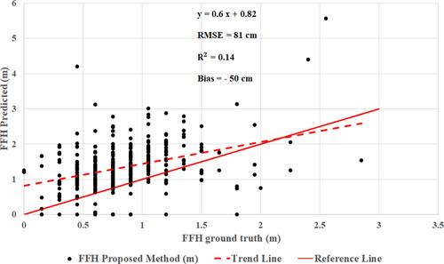
Flood events can cause extensive damage to physical infrastructure, pose risks to human life, and necessitate the reoccupation and rehabilitation of affected areas. A key parameter for flood vulnerability assessment is the first floor height (FFH), which also plays an important role in setting insurance premiums. Traditional methods for FFH estimation rely on ground surveys and site inspections, yet these approaches are both time-consuming and labor-intensive. In this study, we propose an alternative approach based on measurements derived from Google Street View (GSV) images and Deep Learning (DL). We employ the YOLOv5s algorithm, which belongs to a family of compound-scaled object detection models trained on the COCO dataset, for the detection of crucial building elements such as the Front Door (FD), stairs, and overall building extent. Additionally, we utilized the YOLOv5s algorithm to identify basement windows and assess the existence of basements. To validate our methodology, we conducted tests in both the Greater Toronto Area (GTA) and the state of Virginia in the United States. The results demonstrate an achievement of RMSE and Bias values of 81 cm and −50 cm for GTA, and 95 cm and −20 cm for the Virginia region, respectively.
期刊介绍:
Journal of Flood Risk Management provides an international platform for knowledge sharing in all areas related to flood risk. Its explicit aim is to disseminate ideas across the range of disciplines where flood related research is carried out and it provides content ranging from leading edge academic papers to applied content with the practitioner in mind.
Readers and authors come from a wide background and include hydrologists, meteorologists, geographers, geomorphologists, conservationists, civil engineers, social scientists, policy makers, insurers and practitioners. They share an interest in managing the complex interactions between the many skills and disciplines that underpin the management of flood risk across the world.

 求助内容:
求助内容: 应助结果提醒方式:


