用两种无码非线性方法模拟沟谷的形成:青藏高原小流域案例研究

IF 7.3 1区 农林科学 Q1 ENVIRONMENTAL SCIENCES
{"title":"用两种无码非线性方法模拟沟谷的形成:青藏高原小流域案例研究","authors":"","doi":"10.1016/j.iswcr.2024.03.002","DOIUrl":null,"url":null,"abstract":"<div><div>Land and soil resources are scarce in the Tibetan Plateau, and the region is facing ecological pressure from climate warming and increasing human activities. As a major ecological problem, gully erosion is destroying land and soil resources on the Tibetan Plateau, but related research is limited, and susceptibility areas and influencing factors are unclear. Machine learning methods are often applied to study gully initiation susceptibility, but they require a programming foundation. Therefore, the Redui watershed on the southern Tibetan Plateau with severe gully erosion was selected to evaluate the susceptibility and influencing factors of gully initiation through 12 influencing factors including topography, human activity, and underlying surface conditions, and all 2310 gully headcut sites. Two non-code nonlinear modeling methods, the categorical Regression (CATREG) and geographical detector (Geodetector) methods, were first used in the spatial modeling of gully initiation susceptibility. The results showed that the gully initiation susceptibility of the hillslope around the alluvial fan was highest. The very high susceptibility areas of the CATREG model and Geodetector model account for 18.2% and 16% of the total, respectively. The main influencing factors of gully initiation were elevation, relief, and soil type recognized by CATREG, and elevation, human footprint, and soil type recognized by Geodetector. Elevation is the primary factor controlling downstream susceptibility in both models. The primary factors in the upper and middle reaches are soil type and relief identified by CATREG. Human footprint, soil type, and distance to road are primary factors in the upper and middle reaches identified by Geodetector. The explanatory power of elevation, elevation-relief interaction, Geodetector model and CATREG model were 39%, 54%, 46.4% and 73.8%, respectively, at extremely significant levels (P &lt; 0.001), which means that the influencing factors were well considered and that the methods have great application potential in the future.</div></div>","PeriodicalId":48622,"journal":{"name":"International Soil and Water Conservation Research","volume":"12 4","pages":"Pages 747-760"},"PeriodicalIF":7.3000,"publicationDate":"2024-03-29","publicationTypes":"Journal Article","fieldsOfStudy":null,"isOpenAccess":false,"openAccessPdf":"","citationCount":"0","resultStr":"{\"title\":\"Modeling gully initiation by two codeless nonlinear methods: A case study in a small watershed on the Tibetan Plateau\",\"authors\":\"\",\"doi\":\"10.1016/j.iswcr.2024.03.002\",\"DOIUrl\":null,\"url\":null,\"abstract\":\"<div><div>Land and soil resources are scarce in the Tibetan Plateau, and the region is facing ecological pressure from climate warming and increasing human activities. As a major ecological problem, gully erosion is destroying land and soil resources on the Tibetan Plateau, but related research is limited, and susceptibility areas and influencing factors are unclear. Machine learning methods are often applied to study gully initiation susceptibility, but they require a programming foundation. Therefore, the Redui watershed on the southern Tibetan Plateau with severe gully erosion was selected to evaluate the susceptibility and influencing factors of gully initiation through 12 influencing factors including topography, human activity, and underlying surface conditions, and all 2310 gully headcut sites. Two non-code nonlinear modeling methods, the categorical Regression (CATREG) and geographical detector (Geodetector) methods, were first used in the spatial modeling of gully initiation susceptibility. The results showed that the gully initiation susceptibility of the hillslope around the alluvial fan was highest. The very high susceptibility areas of the CATREG model and Geodetector model account for 18.2% and 16% of the total, respectively. The main influencing factors of gully initiation were elevation, relief, and soil type recognized by CATREG, and elevation, human footprint, and soil type recognized by Geodetector. Elevation is the primary factor controlling downstream susceptibility in both models. The primary factors in the upper and middle reaches are soil type and relief identified by CATREG. Human footprint, soil type, and distance to road are primary factors in the upper and middle reaches identified by Geodetector. The explanatory power of elevation, elevation-relief interaction, Geodetector model and CATREG model were 39%, 54%, 46.4% and 73.8%, respectively, at extremely significant levels (P &lt; 0.001), which means that the influencing factors were well considered and that the methods have great application potential in the future.</div></div>\",\"PeriodicalId\":48622,\"journal\":{\"name\":\"International Soil and Water Conservation Research\",\"volume\":\"12 4\",\"pages\":\"Pages 747-760\"},\"PeriodicalIF\":7.3000,\"publicationDate\":\"2024-03-29\",\"publicationTypes\":\"Journal Article\",\"fieldsOfStudy\":null,\"isOpenAccess\":false,\"openAccessPdf\":\"\",\"citationCount\":\"0\",\"resultStr\":null,\"platform\":\"Semanticscholar\",\"paperid\":null,\"PeriodicalName\":\"International Soil and Water Conservation Research\",\"FirstCategoryId\":\"93\",\"ListUrlMain\":\"https://www.sciencedirect.com/science/article/pii/S2095633924000212\",\"RegionNum\":1,\"RegionCategory\":\"农林科学\",\"ArticlePicture\":[],\"TitleCN\":null,\"AbstractTextCN\":null,\"PMCID\":null,\"EPubDate\":\"\",\"PubModel\":\"\",\"JCR\":\"Q1\",\"JCRName\":\"ENVIRONMENTAL SCIENCES\",\"Score\":null,\"Total\":0}","platform":"Semanticscholar","paperid":null,"PeriodicalName":"International Soil and Water Conservation Research","FirstCategoryId":"93","ListUrlMain":"https://www.sciencedirect.com/science/article/pii/S2095633924000212","RegionNum":1,"RegionCategory":"农林科学","ArticlePicture":[],"TitleCN":null,"AbstractTextCN":null,"PMCID":null,"EPubDate":"","PubModel":"","JCR":"Q1","JCRName":"ENVIRONMENTAL SCIENCES","Score":null,"Total":0}
引用次数: 0

摘要

青藏高原的土地和土壤资源稀缺,该地区正面临着气候变暖和人类活动增加所带来的生态压力。作为一个主要的生态问题,沟壑侵蚀正在破坏青藏高原的土地和土壤资源,但相关研究有限,易发区和影响因素不明确。机器学习方法通常被用于研究沟壑的易发性,但需要一定的编程基础。因此,选择了青藏高原南部冲沟侵蚀严重的红堆流域,通过地形地貌、人类活动、地表基础条件等 12 个影响因素和全部 2310 个沟头切迹点,评估了冲沟形成的易感性和影响因素。首先使用了两种非编码非线性建模方法,即分类回归法(CATREG)和地理检测器法(Geodetector),对冲沟形成的敏感性进行了空间建模。结果表明,冲积扇周围山坡的成沟易感性最高。CATREG 模型和 Geodetector 模型的极高易发区分别占总易发区的 18.2% 和 16%。沟谷形成的主要影响因素是 CATREG 识别的海拔、地势和土壤类型,以及 Geodetector 识别的海拔、人类足迹和土壤类型。在这两个模型中,海拔都是控制下游易发性的主要因素。中上游的主要因素是 CATREG 识别的土壤类型和地形。人类足迹、土壤类型和与道路的距离是 Geodetector 确定的上游和中游的主要因素。高程、高程-地形交互作用、Geodetector 模型和 CATREG 模型的解释力分别为 39%、54%、46.4% 和 73.8%,均达到极显著水平(P < 0.001),这说明影响因素考虑周全,这些方法在未来有很大的应用潜力。
本文章由计算机程序翻译,如有差异,请以英文原文为准。

Modeling gully initiation by two codeless nonlinear methods: A case study in a small watershed on the Tibetan Plateau

Modeling gully initiation by two codeless nonlinear methods: A case study in a small watershed on the Tibetan Plateau
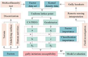
Land and soil resources are scarce in the Tibetan Plateau, and the region is facing ecological pressure from climate warming and increasing human activities. As a major ecological problem, gully erosion is destroying land and soil resources on the Tibetan Plateau, but related research is limited, and susceptibility areas and influencing factors are unclear. Machine learning methods are often applied to study gully initiation susceptibility, but they require a programming foundation. Therefore, the Redui watershed on the southern Tibetan Plateau with severe gully erosion was selected to evaluate the susceptibility and influencing factors of gully initiation through 12 influencing factors including topography, human activity, and underlying surface conditions, and all 2310 gully headcut sites. Two non-code nonlinear modeling methods, the categorical Regression (CATREG) and geographical detector (Geodetector) methods, were first used in the spatial modeling of gully initiation susceptibility. The results showed that the gully initiation susceptibility of the hillslope around the alluvial fan was highest. The very high susceptibility areas of the CATREG model and Geodetector model account for 18.2% and 16% of the total, respectively. The main influencing factors of gully initiation were elevation, relief, and soil type recognized by CATREG, and elevation, human footprint, and soil type recognized by Geodetector. Elevation is the primary factor controlling downstream susceptibility in both models. The primary factors in the upper and middle reaches are soil type and relief identified by CATREG. Human footprint, soil type, and distance to road are primary factors in the upper and middle reaches identified by Geodetector. The explanatory power of elevation, elevation-relief interaction, Geodetector model and CATREG model were 39%, 54%, 46.4% and 73.8%, respectively, at extremely significant levels (P < 0.001), which means that the influencing factors were well considered and that the methods have great application potential in the future.
求助全文
通过发布文献求助,成功后即可免费获取论文全文。 去求助
来源期刊
International Soil and Water Conservation Research
International Soil and Water Conservation Research Agricultural and Biological Sciences-Agronomy and Crop Science
CiteScore
12.00
自引率
3.10%
发文量
171
审稿时长
49 days
期刊介绍: The International Soil and Water Conservation Research (ISWCR), the official journal of World Association of Soil and Water Conservation (WASWAC) http://www.waswac.org, is a multidisciplinary journal of soil and water conservation research, practice, policy, and perspectives. It aims to disseminate new knowledge and promote the practice of soil and water conservation. The scope of International Soil and Water Conservation Research includes research, strategies, and technologies for prediction, prevention, and protection of soil and water resources. It deals with identification, characterization, and modeling; dynamic monitoring and evaluation; assessment and management of conservation practice and creation and implementation of quality standards. Examples of appropriate topical areas include (but are not limited to): • Conservation models, tools, and technologies • Conservation agricultural • Soil health resources, indicators, assessment, and management • Land degradation • Sustainable development • Soil erosion and its control • Soil erosion processes • Water resources assessment and management • Watershed management • Soil erosion models • Literature review on topics related soil and water conservation research
×
引用
GB/T 7714-2015
复制
MLA
复制
APA
复制
导出至
BibTeX EndNote RefMan NoteFirst NoteExpress
×
提示
您的信息不完整,为了账户安全,请先补充。
现在去补充
×
提示
您因"违规操作"
具体请查看互助需知
我知道了
×
提示
确定
请完成安全验证×
copy
已复制链接
快去分享给好友吧!
我知道了
右上角分享
点击右上角分享
0
联系我们:info@booksci.cn Book学术提供免费学术资源搜索服务,方便国内外学者检索中英文文献。致力于提供最便捷和优质的服务体验。 Copyright © 2023 布克学术 All rights reserved.
京ICP备2023020795号-1
ghs 京公网安备 11010802042870号
Book学术文献互助
Book学术文献互助群
群 号:481959085
Book学术官方微信