{"title":"利用地理空间技术划定孟加拉国太阳能光伏发电站安装的合适地点","authors":"M.M. Shah Porun Rana, Md. Moniruzzaman","doi":"10.1016/j.nxener.2024.100109","DOIUrl":null,"url":null,"abstract":"<div><p>The major goal of this research is to adopt analytical hierarchy process (AHP) based geospatial technique to select suitable zone for the solar photovoltaic (PV) power plants. Nine thematic layers altogether—slope, global horizontal irradiation (GHI), relative humidity, direct normal irradiation (DNI), elevation, distance from major roads, distance from protected areas, rainfall, and land use/land cover (LULC)—are combined through overlay analysis in ArcGIS to create the final map of suitability for the placement of solar photovoltaic (PV) power plants in Bangladesh. This map has been classified into five categories namely, restricted zone, less suitable zone, moderate suitable zone, good suitable zone, and excellent suitable zone. These categories are covered by 7.28%, 16.61%, 28.51%, 27.77%, 21.83% land of total area in Bangladesh respectively. The findings of this research have been presented that ‘the excellent suitable’ and ‘good suitable’ areas for the construction of solar power plants are in the western and northwestern part (Rajshahi, Pabna, Sirajganj, Natore, Naogaon, Chapainawabganj, Bogura, Faridpur, Jessore, Jehenaidha, Magura, Kushtia, Choudanga, Meherpur) of the study area which contain a high value of global horizontal irradiation, direct normal irradiation, elevation and low value of slope, rainfall, temperature, relative humidity. Besides the restricted and less suitable zone for installing solar photovoltaic (PV) power plants indicates a high value of rainfall, slope, temperature, relative humidity and low value of global horizontal irradiation, direct normal irradiation, and elevation. Bangladesh's currently operational solar plants were taken into consideration for this study's validation purposes. The proposed framework may potentially be used in different locales on a national and worldwide scale. This study offers a consistent GIS process for the accurate, inexpensive implementation of a solar energy plan to achieve environmentally friendly goals.</p></div>","PeriodicalId":100957,"journal":{"name":"Next Energy","volume":null,"pages":null},"PeriodicalIF":0.0000,"publicationDate":"2024-04-01","publicationTypes":"Journal Article","fieldsOfStudy":null,"isOpenAccess":false,"openAccessPdf":"https://www.sciencedirect.com/science/article/pii/S2949821X24000140/pdfft?md5=07be1f5fd95f0578044c68c9ac207aa5&pid=1-s2.0-S2949821X24000140-main.pdf","citationCount":"0","resultStr":"{\"title\":\"Demarcation of suitable site for solar photovoltaic power plant installation in Bangladesh using geospatial techniques\",\"authors\":\"M.M. Shah Porun Rana, Md. Moniruzzaman\",\"doi\":\"10.1016/j.nxener.2024.100109\",\"DOIUrl\":null,\"url\":null,\"abstract\":\"<div><p>The major goal of this research is to adopt analytical hierarchy process (AHP) based geospatial technique to select suitable zone for the solar photovoltaic (PV) power plants. Nine thematic layers altogether—slope, global horizontal irradiation (GHI), relative humidity, direct normal irradiation (DNI), elevation, distance from major roads, distance from protected areas, rainfall, and land use/land cover (LULC)—are combined through overlay analysis in ArcGIS to create the final map of suitability for the placement of solar photovoltaic (PV) power plants in Bangladesh. This map has been classified into five categories namely, restricted zone, less suitable zone, moderate suitable zone, good suitable zone, and excellent suitable zone. These categories are covered by 7.28%, 16.61%, 28.51%, 27.77%, 21.83% land of total area in Bangladesh respectively. The findings of this research have been presented that ‘the excellent suitable’ and ‘good suitable’ areas for the construction of solar power plants are in the western and northwestern part (Rajshahi, Pabna, Sirajganj, Natore, Naogaon, Chapainawabganj, Bogura, Faridpur, Jessore, Jehenaidha, Magura, Kushtia, Choudanga, Meherpur) of the study area which contain a high value of global horizontal irradiation, direct normal irradiation, elevation and low value of slope, rainfall, temperature, relative humidity. Besides the restricted and less suitable zone for installing solar photovoltaic (PV) power plants indicates a high value of rainfall, slope, temperature, relative humidity and low value of global horizontal irradiation, direct normal irradiation, and elevation. Bangladesh's currently operational solar plants were taken into consideration for this study's validation purposes. The proposed framework may potentially be used in different locales on a national and worldwide scale. This study offers a consistent GIS process for the accurate, inexpensive implementation of a solar energy plan to achieve environmentally friendly goals.</p></div>\",\"PeriodicalId\":100957,\"journal\":{\"name\":\"Next Energy\",\"volume\":null,\"pages\":null},\"PeriodicalIF\":0.0000,\"publicationDate\":\"2024-04-01\",\"publicationTypes\":\"Journal Article\",\"fieldsOfStudy\":null,\"isOpenAccess\":false,\"openAccessPdf\":\"https://www.sciencedirect.com/science/article/pii/S2949821X24000140/pdfft?md5=07be1f5fd95f0578044c68c9ac207aa5&pid=1-s2.0-S2949821X24000140-main.pdf\",\"citationCount\":\"0\",\"resultStr\":null,\"platform\":\"Semanticscholar\",\"paperid\":null,\"PeriodicalName\":\"Next Energy\",\"FirstCategoryId\":\"1085\",\"ListUrlMain\":\"https://www.sciencedirect.com/science/article/pii/S2949821X24000140\",\"RegionNum\":0,\"RegionCategory\":null,\"ArticlePicture\":[],\"TitleCN\":null,\"AbstractTextCN\":null,\"PMCID\":null,\"EPubDate\":\"\",\"PubModel\":\"\",\"JCR\":\"\",\"JCRName\":\"\",\"Score\":null,\"Total\":0}","platform":"Semanticscholar","paperid":null,"PeriodicalName":"Next Energy","FirstCategoryId":"1085","ListUrlMain":"https://www.sciencedirect.com/science/article/pii/S2949821X24000140","RegionNum":0,"RegionCategory":null,"ArticlePicture":[],"TitleCN":null,"AbstractTextCN":null,"PMCID":null,"EPubDate":"","PubModel":"","JCR":"","JCRName":"","Score":null,"Total":0}
Demarcation of suitable site for solar photovoltaic power plant installation in Bangladesh using geospatial techniques
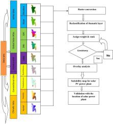
The major goal of this research is to adopt analytical hierarchy process (AHP) based geospatial technique to select suitable zone for the solar photovoltaic (PV) power plants. Nine thematic layers altogether—slope, global horizontal irradiation (GHI), relative humidity, direct normal irradiation (DNI), elevation, distance from major roads, distance from protected areas, rainfall, and land use/land cover (LULC)—are combined through overlay analysis in ArcGIS to create the final map of suitability for the placement of solar photovoltaic (PV) power plants in Bangladesh. This map has been classified into five categories namely, restricted zone, less suitable zone, moderate suitable zone, good suitable zone, and excellent suitable zone. These categories are covered by 7.28%, 16.61%, 28.51%, 27.77%, 21.83% land of total area in Bangladesh respectively. The findings of this research have been presented that ‘the excellent suitable’ and ‘good suitable’ areas for the construction of solar power plants are in the western and northwestern part (Rajshahi, Pabna, Sirajganj, Natore, Naogaon, Chapainawabganj, Bogura, Faridpur, Jessore, Jehenaidha, Magura, Kushtia, Choudanga, Meherpur) of the study area which contain a high value of global horizontal irradiation, direct normal irradiation, elevation and low value of slope, rainfall, temperature, relative humidity. Besides the restricted and less suitable zone for installing solar photovoltaic (PV) power plants indicates a high value of rainfall, slope, temperature, relative humidity and low value of global horizontal irradiation, direct normal irradiation, and elevation. Bangladesh's currently operational solar plants were taken into consideration for this study's validation purposes. The proposed framework may potentially be used in different locales on a national and worldwide scale. This study offers a consistent GIS process for the accurate, inexpensive implementation of a solar energy plan to achieve environmentally friendly goals.

 求助内容:
求助内容: 应助结果提醒方式:


