Philipp J. Wolpert, Martin Bartenbach, Thomas Aigner, Augustus O. Wilson, Moujahed I. Al-Husseini, Alexander Petrovic, Heiko Dirks, Randolf Rausch
{"title":"沙特阿拉伯达哈尔希特露头地层中的蒂索尼希特无水岩层的沉积学和层序地层学分析","authors":"Philipp J. Wolpert, Martin Bartenbach, Thomas Aigner, Augustus O. Wilson, Moujahed I. Al-Husseini, Alexander Petrovic, Heiko Dirks, Randolf Rausch","doi":"10.1007/s12517-024-11911-w","DOIUrl":null,"url":null,"abstract":"<p>The Dahal Hit cavern in Central Saudi Arabia is the only locality where the Tithonian Hith Anhydrite Formation is exposed in the Middle East. In 2010, a 28.5-m interval in the 90-m-thick Hith Formation was logged and described in the cavern as part of a study to evaluate its sedimentological and sequence-stratigraphic architecture and to identify potential high-permeability layers within the seal of the world’s most prolific petroleum system. Seven facies types were interpreted as reflecting sabkha (subaerial) or salina (subaqueous) settings, and their vertical stacking patterns revealed that the logged interval consists of three transgressive–regressive cycles and part of a fourth cycle. The cavern was revisited in 2016 but only to find that the water level had risen by about 50 m rendering further geological studies impossible. The higher level of the water suggests that the cavern was flooded by the flow in the subsurface of treated sewage water released into a former quarry. The quarry is situated about 10 km southeast of the cavern, and the storage of water in it started in 2008. The flow pathways to the Dahal Hit cavern are apparently well-connected karsts, caverns, and high-permeability flow zones present in dolomite layers.</p>","PeriodicalId":476,"journal":{"name":"Arabian Journal of Geosciences","volume":null,"pages":null},"PeriodicalIF":1.8270,"publicationDate":"2024-03-26","publicationTypes":"Journal Article","fieldsOfStudy":null,"isOpenAccess":false,"openAccessPdf":"","citationCount":"0","resultStr":"{\"title\":\"Sedimentological and sequence-stratigraphic analyses of the Tithonian Hith Anhydrite Formation in the Dahal Hit outcrop, Saudi Arabia\",\"authors\":\"Philipp J. Wolpert, Martin Bartenbach, Thomas Aigner, Augustus O. Wilson, Moujahed I. Al-Husseini, Alexander Petrovic, Heiko Dirks, Randolf Rausch\",\"doi\":\"10.1007/s12517-024-11911-w\",\"DOIUrl\":null,\"url\":null,\"abstract\":\"<p>The Dahal Hit cavern in Central Saudi Arabia is the only locality where the Tithonian Hith Anhydrite Formation is exposed in the Middle East. In 2010, a 28.5-m interval in the 90-m-thick Hith Formation was logged and described in the cavern as part of a study to evaluate its sedimentological and sequence-stratigraphic architecture and to identify potential high-permeability layers within the seal of the world’s most prolific petroleum system. Seven facies types were interpreted as reflecting sabkha (subaerial) or salina (subaqueous) settings, and their vertical stacking patterns revealed that the logged interval consists of three transgressive–regressive cycles and part of a fourth cycle. The cavern was revisited in 2016 but only to find that the water level had risen by about 50 m rendering further geological studies impossible. The higher level of the water suggests that the cavern was flooded by the flow in the subsurface of treated sewage water released into a former quarry. The quarry is situated about 10 km southeast of the cavern, and the storage of water in it started in 2008. The flow pathways to the Dahal Hit cavern are apparently well-connected karsts, caverns, and high-permeability flow zones present in dolomite layers.</p>\",\"PeriodicalId\":476,\"journal\":{\"name\":\"Arabian Journal of Geosciences\",\"volume\":null,\"pages\":null},\"PeriodicalIF\":1.8270,\"publicationDate\":\"2024-03-26\",\"publicationTypes\":\"Journal Article\",\"fieldsOfStudy\":null,\"isOpenAccess\":false,\"openAccessPdf\":\"\",\"citationCount\":\"0\",\"resultStr\":null,\"platform\":\"Semanticscholar\",\"paperid\":null,\"PeriodicalName\":\"Arabian Journal of Geosciences\",\"FirstCategoryId\":\"1085\",\"ListUrlMain\":\"https://doi.org/10.1007/s12517-024-11911-w\",\"RegionNum\":0,\"RegionCategory\":null,\"ArticlePicture\":[],\"TitleCN\":null,\"AbstractTextCN\":null,\"PMCID\":null,\"EPubDate\":\"\",\"PubModel\":\"\",\"JCR\":\"Q2\",\"JCRName\":\"Earth and Planetary Sciences\",\"Score\":null,\"Total\":0}","platform":"Semanticscholar","paperid":null,"PeriodicalName":"Arabian Journal of Geosciences","FirstCategoryId":"1085","ListUrlMain":"https://doi.org/10.1007/s12517-024-11911-w","RegionNum":0,"RegionCategory":null,"ArticlePicture":[],"TitleCN":null,"AbstractTextCN":null,"PMCID":null,"EPubDate":"","PubModel":"","JCR":"Q2","JCRName":"Earth and Planetary Sciences","Score":null,"Total":0}
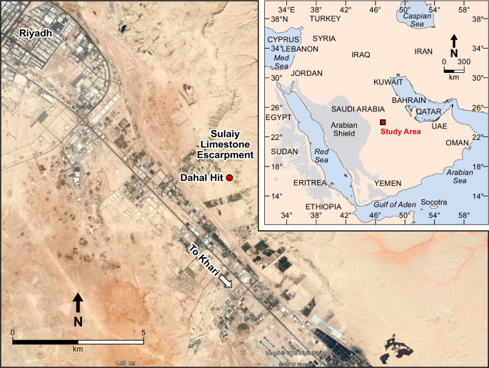
Sedimentological and sequence-stratigraphic analyses of the Tithonian Hith Anhydrite Formation in the Dahal Hit outcrop, Saudi Arabia
The Dahal Hit cavern in Central Saudi Arabia is the only locality where the Tithonian Hith Anhydrite Formation is exposed in the Middle East. In 2010, a 28.5-m interval in the 90-m-thick Hith Formation was logged and described in the cavern as part of a study to evaluate its sedimentological and sequence-stratigraphic architecture and to identify potential high-permeability layers within the seal of the world’s most prolific petroleum system. Seven facies types were interpreted as reflecting sabkha (subaerial) or salina (subaqueous) settings, and their vertical stacking patterns revealed that the logged interval consists of three transgressive–regressive cycles and part of a fourth cycle. The cavern was revisited in 2016 but only to find that the water level had risen by about 50 m rendering further geological studies impossible. The higher level of the water suggests that the cavern was flooded by the flow in the subsurface of treated sewage water released into a former quarry. The quarry is situated about 10 km southeast of the cavern, and the storage of water in it started in 2008. The flow pathways to the Dahal Hit cavern are apparently well-connected karsts, caverns, and high-permeability flow zones present in dolomite layers.
期刊介绍:
The Arabian Journal of Geosciences is the official journal of the Saudi Society for Geosciences and publishes peer-reviewed original and review articles on the entire range of Earth Science themes, focused on, but not limited to, those that have regional significance to the Middle East and the Euro-Mediterranean Zone.
Key topics therefore include; geology, hydrogeology, earth system science, petroleum sciences, geophysics, seismology and crustal structures, tectonics, sedimentology, palaeontology, metamorphic and igneous petrology, natural hazards, environmental sciences and sustainable development, geoarchaeology, geomorphology, paleo-environment studies, oceanography, atmospheric sciences, GIS and remote sensing, geodesy, mineralogy, volcanology, geochemistry and metallogenesis.

 求助内容:
求助内容: 应助结果提醒方式:


