Kristen L. Wilson, Andrea Hilborn, Stephanie Clay, Emmanuel Devred
{"title":"改进加拿大芬迪湾浑浊水域的卫星叶绿素 a 检索","authors":"Kristen L. Wilson, Andrea Hilborn, Stephanie Clay, Emmanuel Devred","doi":"10.1007/s12237-024-01334-x","DOIUrl":null,"url":null,"abstract":"<p>The Bay of Fundy is a highly productive ecosystem within the Northwest Atlantic where extreme tides and strong currents result in a large gradient of sediment concentrations across and along the bay. We processed daily satellite data from the MODerate resolution Imaging Spectroradiometer (MODIS) on the Aqua satellite from 2003 to 2021 at 300-m resolution to understand and quantify spatial and temporal trends in chlorophyll-a concentration (chl-a, a measure of phytoplankton biomass), and suspended particulate matter concentration (SPM) in the Bay of Fundy surface waters. To account for high sediment loading (up to 100’s g m<sup>−3</sup>) and moderate chl-a (median in situ chl-a of 1.5 mg m<sup>−3</sup> from 2003 to 2021), coefficients of the OC3M chl-a algorithm were regionally tuned using in situ chl-a data, and satellite-derived SPM was incorporated within the chl-a retrieval algorithm to account for possible bias. The updated new algorithm was denoted as OC<sub>X-SPMCor</sub>. Chl-a computed using OC<sub>X-SPMCor</sub> showed better performance against in situ chl-a than the generic OC3M with a coefficient of determination that increased from 0.01 to 0.28 and a root mean square logarithmic error that decreased by 35%. Unlike previous remote sensing studies, OC<sub>X-SPMCor</sub> correctly predicted the particular chl-a seasonality in the Bay of Fundy, which does not follow the typical occurrence of spring/fall blooms as observed in the adjacent Gulf of Maine and Scotian Shelf. For the first time, satellite-predicted chl-a aligned with the phenology of in situ chl-a, where chl-a continually increased from April to June and remained high all summer, with a small secondary summer peak before decreasing in the fall. SPM seasonality followed an opposite trend where SPM reached a maximum in winter and a minimum in summer. A small number of matchups and high temporal variability on the hourly time scale precluded a robust assessment of the satellite-derived SPM. However, comparisons between time series of remotely sensed and in situ SPM demonstrated the ability of the satellite-derived SPM to capture temporal variations, though the absolute values may be slightly underestimated. Accurate maps of phytoplankton biomass and sediment concentrations are essential variables required for effective management and conservation of marine ecosystems in the Bay of Fundy.</p>","PeriodicalId":11921,"journal":{"name":"Estuaries and Coasts","volume":"81 1","pages":""},"PeriodicalIF":2.3000,"publicationDate":"2024-03-15","publicationTypes":"Journal Article","fieldsOfStudy":null,"isOpenAccess":false,"openAccessPdf":"","citationCount":"0","resultStr":"{\"title\":\"Improving Satellite Chlorophyll-a Retrieval in the Turbid Waters of the Bay of Fundy, Canada\",\"authors\":\"Kristen L. Wilson, Andrea Hilborn, Stephanie Clay, Emmanuel Devred\",\"doi\":\"10.1007/s12237-024-01334-x\",\"DOIUrl\":null,\"url\":null,\"abstract\":\"<p>The Bay of Fundy is a highly productive ecosystem within the Northwest Atlantic where extreme tides and strong currents result in a large gradient of sediment concentrations across and along the bay. We processed daily satellite data from the MODerate resolution Imaging Spectroradiometer (MODIS) on the Aqua satellite from 2003 to 2021 at 300-m resolution to understand and quantify spatial and temporal trends in chlorophyll-a concentration (chl-a, a measure of phytoplankton biomass), and suspended particulate matter concentration (SPM) in the Bay of Fundy surface waters. To account for high sediment loading (up to 100’s g m<sup>−3</sup>) and moderate chl-a (median in situ chl-a of 1.5 mg m<sup>−3</sup> from 2003 to 2021), coefficients of the OC3M chl-a algorithm were regionally tuned using in situ chl-a data, and satellite-derived SPM was incorporated within the chl-a retrieval algorithm to account for possible bias. The updated new algorithm was denoted as OC<sub>X-SPMCor</sub>. Chl-a computed using OC<sub>X-SPMCor</sub> showed better performance against in situ chl-a than the generic OC3M with a coefficient of determination that increased from 0.01 to 0.28 and a root mean square logarithmic error that decreased by 35%. Unlike previous remote sensing studies, OC<sub>X-SPMCor</sub> correctly predicted the particular chl-a seasonality in the Bay of Fundy, which does not follow the typical occurrence of spring/fall blooms as observed in the adjacent Gulf of Maine and Scotian Shelf. For the first time, satellite-predicted chl-a aligned with the phenology of in situ chl-a, where chl-a continually increased from April to June and remained high all summer, with a small secondary summer peak before decreasing in the fall. SPM seasonality followed an opposite trend where SPM reached a maximum in winter and a minimum in summer. A small number of matchups and high temporal variability on the hourly time scale precluded a robust assessment of the satellite-derived SPM. However, comparisons between time series of remotely sensed and in situ SPM demonstrated the ability of the satellite-derived SPM to capture temporal variations, though the absolute values may be slightly underestimated. Accurate maps of phytoplankton biomass and sediment concentrations are essential variables required for effective management and conservation of marine ecosystems in the Bay of Fundy.</p>\",\"PeriodicalId\":11921,\"journal\":{\"name\":\"Estuaries and Coasts\",\"volume\":\"81 1\",\"pages\":\"\"},\"PeriodicalIF\":2.3000,\"publicationDate\":\"2024-03-15\",\"publicationTypes\":\"Journal Article\",\"fieldsOfStudy\":null,\"isOpenAccess\":false,\"openAccessPdf\":\"\",\"citationCount\":\"0\",\"resultStr\":null,\"platform\":\"Semanticscholar\",\"paperid\":null,\"PeriodicalName\":\"Estuaries and Coasts\",\"FirstCategoryId\":\"93\",\"ListUrlMain\":\"https://doi.org/10.1007/s12237-024-01334-x\",\"RegionNum\":3,\"RegionCategory\":\"环境科学与生态学\",\"ArticlePicture\":[],\"TitleCN\":null,\"AbstractTextCN\":null,\"PMCID\":null,\"EPubDate\":\"\",\"PubModel\":\"\",\"JCR\":\"Q3\",\"JCRName\":\"ENVIRONMENTAL SCIENCES\",\"Score\":null,\"Total\":0}","platform":"Semanticscholar","paperid":null,"PeriodicalName":"Estuaries and Coasts","FirstCategoryId":"93","ListUrlMain":"https://doi.org/10.1007/s12237-024-01334-x","RegionNum":3,"RegionCategory":"环境科学与生态学","ArticlePicture":[],"TitleCN":null,"AbstractTextCN":null,"PMCID":null,"EPubDate":"","PubModel":"","JCR":"Q3","JCRName":"ENVIRONMENTAL SCIENCES","Score":null,"Total":0}
Improving Satellite Chlorophyll-a Retrieval in the Turbid Waters of the Bay of Fundy, Canada
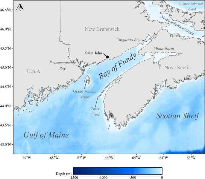
The Bay of Fundy is a highly productive ecosystem within the Northwest Atlantic where extreme tides and strong currents result in a large gradient of sediment concentrations across and along the bay. We processed daily satellite data from the MODerate resolution Imaging Spectroradiometer (MODIS) on the Aqua satellite from 2003 to 2021 at 300-m resolution to understand and quantify spatial and temporal trends in chlorophyll-a concentration (chl-a, a measure of phytoplankton biomass), and suspended particulate matter concentration (SPM) in the Bay of Fundy surface waters. To account for high sediment loading (up to 100’s g m−3) and moderate chl-a (median in situ chl-a of 1.5 mg m−3 from 2003 to 2021), coefficients of the OC3M chl-a algorithm were regionally tuned using in situ chl-a data, and satellite-derived SPM was incorporated within the chl-a retrieval algorithm to account for possible bias. The updated new algorithm was denoted as OCX-SPMCor. Chl-a computed using OCX-SPMCor showed better performance against in situ chl-a than the generic OC3M with a coefficient of determination that increased from 0.01 to 0.28 and a root mean square logarithmic error that decreased by 35%. Unlike previous remote sensing studies, OCX-SPMCor correctly predicted the particular chl-a seasonality in the Bay of Fundy, which does not follow the typical occurrence of spring/fall blooms as observed in the adjacent Gulf of Maine and Scotian Shelf. For the first time, satellite-predicted chl-a aligned with the phenology of in situ chl-a, where chl-a continually increased from April to June and remained high all summer, with a small secondary summer peak before decreasing in the fall. SPM seasonality followed an opposite trend where SPM reached a maximum in winter and a minimum in summer. A small number of matchups and high temporal variability on the hourly time scale precluded a robust assessment of the satellite-derived SPM. However, comparisons between time series of remotely sensed and in situ SPM demonstrated the ability of the satellite-derived SPM to capture temporal variations, though the absolute values may be slightly underestimated. Accurate maps of phytoplankton biomass and sediment concentrations are essential variables required for effective management and conservation of marine ecosystems in the Bay of Fundy.
期刊介绍:
Estuaries and Coasts is the journal of the Coastal and Estuarine Research Federation (CERF). Begun in 1977 as Chesapeake Science, the journal has gradually expanded its scope and circulation. Today, the journal publishes scholarly manuscripts on estuarine and near coastal ecosystems at the interface between the land and the sea where there are tidal fluctuations or sea water is diluted by fresh water. The interface is broadly defined to include estuaries and nearshore coastal waters including lagoons, wetlands, tidal fresh water, shores and beaches, but not the continental shelf. The journal covers research on physical, chemical, geological or biological processes, as well as applications to management of estuaries and coasts. The journal publishes original research findings, reviews and perspectives, techniques, comments, and management applications. Estuaries and Coasts will consider properly carried out studies that present inconclusive findings or document a failed replication of previously published work. Submissions that are primarily descriptive, strongly place-based, or only report on development of models or new methods without detailing their applications fall outside the scope of the journal.
 求助内容:
求助内容: 应助结果提醒方式:


