Shaorui Li , Zhenchang Zhu , Weitang Deng , Qin Zhu , Zhihao Xu , Bo Peng , Fen Guo , Yuan Zhang , Zhifeng Yang
{"title":"基于无人机遥感估算红树林不同植被类型的地上生物量","authors":"Shaorui Li , Zhenchang Zhu , Weitang Deng , Qin Zhu , Zhihao Xu , Bo Peng , Fen Guo , Yuan Zhang , Zhifeng Yang","doi":"10.1016/j.horiz.2024.100100","DOIUrl":null,"url":null,"abstract":"<div><p>Accurate estimating biomass is essential for monitoring mangrove dynamics and quantifying its carbon stocks. Utilizing Unmanned Aerial Vehicle (UAV) monitoring to replace manual surveys for biomass estimation offers advantages such as broad coverage and rapid data collection. However, uncertainty exists in selecting appropriate UAV inversion parameters. Meanwhile, accurate biomass estimation of mangrove is challenging as its low penetration, especially the difficult for distinguishing between different mangrove vegetation types. In this study, we combined UAV and Light Detection and Ranging (LiDAR) to accurately estimate the biomass of different mangrove vegetation types. Using the UAV-mounted LiDAR as a sampling tool, we obtain Three-Dimensional (3D) point cloud data of six dominant mangrove vegetation types in South China. Combining such data with field measurements, we analyzed the impact of different inversion parameters on biomass estimation accuracy of different mangrove vegetation types. The results demonstrated that the combination of average canopy height and average canopy effective cover generally yielded the highest accuracy for estimating mangrove biomass. Moreover, refinement of biomass estimation for different mangrove vegetation types with curve fits further improved accuracy. The current work provides an effective tool to accurately quantify the aboveground biomass of different mangrove vegetation at a range of scales. This carries significant implications for assessing its distribution status and characterizing its functions such as carbon sequestration.</p></div>","PeriodicalId":101199,"journal":{"name":"Sustainable Horizons","volume":"11 ","pages":"Article 100100"},"PeriodicalIF":0.0000,"publicationDate":"2024-03-07","publicationTypes":"Journal Article","fieldsOfStudy":null,"isOpenAccess":false,"openAccessPdf":"https://www.sciencedirect.com/science/article/pii/S2772737824000129/pdfft?md5=0525d7d2e9448a5762e2d67a3e2aeb52&pid=1-s2.0-S2772737824000129-main.pdf","citationCount":"0","resultStr":"{\"title\":\"Estimation of aboveground biomass of different vegetation types in mangrove forests based on UAV remote sensing\",\"authors\":\"Shaorui Li , Zhenchang Zhu , Weitang Deng , Qin Zhu , Zhihao Xu , Bo Peng , Fen Guo , Yuan Zhang , Zhifeng Yang\",\"doi\":\"10.1016/j.horiz.2024.100100\",\"DOIUrl\":null,\"url\":null,\"abstract\":\"<div><p>Accurate estimating biomass is essential for monitoring mangrove dynamics and quantifying its carbon stocks. Utilizing Unmanned Aerial Vehicle (UAV) monitoring to replace manual surveys for biomass estimation offers advantages such as broad coverage and rapid data collection. However, uncertainty exists in selecting appropriate UAV inversion parameters. Meanwhile, accurate biomass estimation of mangrove is challenging as its low penetration, especially the difficult for distinguishing between different mangrove vegetation types. In this study, we combined UAV and Light Detection and Ranging (LiDAR) to accurately estimate the biomass of different mangrove vegetation types. Using the UAV-mounted LiDAR as a sampling tool, we obtain Three-Dimensional (3D) point cloud data of six dominant mangrove vegetation types in South China. Combining such data with field measurements, we analyzed the impact of different inversion parameters on biomass estimation accuracy of different mangrove vegetation types. The results demonstrated that the combination of average canopy height and average canopy effective cover generally yielded the highest accuracy for estimating mangrove biomass. Moreover, refinement of biomass estimation for different mangrove vegetation types with curve fits further improved accuracy. The current work provides an effective tool to accurately quantify the aboveground biomass of different mangrove vegetation at a range of scales. This carries significant implications for assessing its distribution status and characterizing its functions such as carbon sequestration.</p></div>\",\"PeriodicalId\":101199,\"journal\":{\"name\":\"Sustainable Horizons\",\"volume\":\"11 \",\"pages\":\"Article 100100\"},\"PeriodicalIF\":0.0000,\"publicationDate\":\"2024-03-07\",\"publicationTypes\":\"Journal Article\",\"fieldsOfStudy\":null,\"isOpenAccess\":false,\"openAccessPdf\":\"https://www.sciencedirect.com/science/article/pii/S2772737824000129/pdfft?md5=0525d7d2e9448a5762e2d67a3e2aeb52&pid=1-s2.0-S2772737824000129-main.pdf\",\"citationCount\":\"0\",\"resultStr\":null,\"platform\":\"Semanticscholar\",\"paperid\":null,\"PeriodicalName\":\"Sustainable Horizons\",\"FirstCategoryId\":\"1085\",\"ListUrlMain\":\"https://www.sciencedirect.com/science/article/pii/S2772737824000129\",\"RegionNum\":0,\"RegionCategory\":null,\"ArticlePicture\":[],\"TitleCN\":null,\"AbstractTextCN\":null,\"PMCID\":null,\"EPubDate\":\"\",\"PubModel\":\"\",\"JCR\":\"\",\"JCRName\":\"\",\"Score\":null,\"Total\":0}","platform":"Semanticscholar","paperid":null,"PeriodicalName":"Sustainable Horizons","FirstCategoryId":"1085","ListUrlMain":"https://www.sciencedirect.com/science/article/pii/S2772737824000129","RegionNum":0,"RegionCategory":null,"ArticlePicture":[],"TitleCN":null,"AbstractTextCN":null,"PMCID":null,"EPubDate":"","PubModel":"","JCR":"","JCRName":"","Score":null,"Total":0}
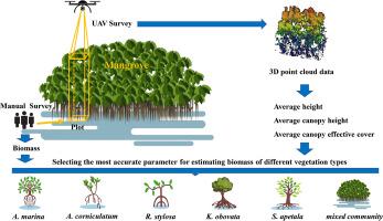
Estimation of aboveground biomass of different vegetation types in mangrove forests based on UAV remote sensing
Accurate estimating biomass is essential for monitoring mangrove dynamics and quantifying its carbon stocks. Utilizing Unmanned Aerial Vehicle (UAV) monitoring to replace manual surveys for biomass estimation offers advantages such as broad coverage and rapid data collection. However, uncertainty exists in selecting appropriate UAV inversion parameters. Meanwhile, accurate biomass estimation of mangrove is challenging as its low penetration, especially the difficult for distinguishing between different mangrove vegetation types. In this study, we combined UAV and Light Detection and Ranging (LiDAR) to accurately estimate the biomass of different mangrove vegetation types. Using the UAV-mounted LiDAR as a sampling tool, we obtain Three-Dimensional (3D) point cloud data of six dominant mangrove vegetation types in South China. Combining such data with field measurements, we analyzed the impact of different inversion parameters on biomass estimation accuracy of different mangrove vegetation types. The results demonstrated that the combination of average canopy height and average canopy effective cover generally yielded the highest accuracy for estimating mangrove biomass. Moreover, refinement of biomass estimation for different mangrove vegetation types with curve fits further improved accuracy. The current work provides an effective tool to accurately quantify the aboveground biomass of different mangrove vegetation at a range of scales. This carries significant implications for assessing its distribution status and characterizing its functions such as carbon sequestration.

 求助内容:
求助内容: 应助结果提醒方式:


