Rami Al-Ruzouq , Abdallah Shanableh , Ratiranjan Jena , Mohammed Barakat A. Gibril , Nezar Atalla Hammouri , Fouad Lamghari
{"title":"利用多时相哨兵-1 数据和极限深度学习模型的新型集成绘制洪水易感性地图","authors":"Rami Al-Ruzouq , Abdallah Shanableh , Ratiranjan Jena , Mohammed Barakat A. Gibril , Nezar Atalla Hammouri , Fouad Lamghari","doi":"10.1016/j.gsf.2024.101780","DOIUrl":null,"url":null,"abstract":"<div><p>Flash floods (FFs) are amongst the most devastating hazards in arid regions in response to climate change and can cause the loss of agricultural land, human lives and infrastructure. One of the major challenges is the high-intensity rainfall events affecting low-lying areas that are vulnerable to FF. Several works in this field have been conducted using ensemble machine learning models and geohydrological models. However, the current advancement of eXtreme deep learning, which is named eXtreme deep factorisation machine (xDeepFM), for FF susceptibility mapping (FSM) is lacking in the literature. The current study introduces a new model and employs a previously unapplied approach to enhance FSM for capturing the severity of floods. The proposed approach has three main objectives: (i) During- and after-flood effects are assessed through flood detection techniques using Sentinel-1 data. (ii) Flood inventory is updated using remote sensing-based methods. The derived flood effects are implemented in the next step. (iii) An FSM map is generated using an xDeepFM model. Therefore, this study aims to apply xDeepFM to estimate susceptible areas using 13 factors in the emirates of Fujairah, UAE. The performance metrics show a recall of 0.9488), an F1-score of 0.9107), precision of (0.8756) and an overall accuracy of 90.41%. The accuracy of the applied xDeepFM model is compared with that of traditional machine learning models, specifically the deep neural network (78%), support vector machine (85.4%) and random forest (88.75%). Random forest achieves high accuracy, which is due to its strong performance that depends on factors contribution, dataset size and quality, and available computational resources. Comparatively, the xDeepFM model works efficiently for complicated prediction problems having high non-collinearity and huge datasets<em>.</em> The obtained map denotes that the narrow basins, lowland coastal areas and riverbank areas up to 5 km (Fujairah) are highly prone to FF, whilst the alluvial plains in Al Dhaid and hilly regions in Fujairah show low probability. The coastal city areas are bounded by high-rise steep hills and the Gulf of Oman, which can elevate the water levels during heavy rainfall. Four major synchronised influencing factors, namely, rainfall, elevation, drainage density, distance from drainage and geomorphology, account for nearly 50% of the total factors contributing to a very high flood susceptibility. This study offers a platform for planners and decision makers to take timely actions on potential areas in mitigating the effects of FF.</p></div>","PeriodicalId":12711,"journal":{"name":"Geoscience frontiers","volume":"15 3","pages":"Article 101780"},"PeriodicalIF":8.9000,"publicationDate":"2024-01-09","publicationTypes":"Journal Article","fieldsOfStudy":null,"isOpenAccess":false,"openAccessPdf":"https://www.sciencedirect.com/science/article/pii/S1674987124000045/pdfft?md5=590fcaec9ad6700ae22afece7ac4e81a&pid=1-s2.0-S1674987124000045-main.pdf","citationCount":"0","resultStr":"{\"title\":\"Flood susceptibility mapping using a novel integration of multi-temporal sentinel-1 data and eXtreme deep learning model\",\"authors\":\"Rami Al-Ruzouq , Abdallah Shanableh , Ratiranjan Jena , Mohammed Barakat A. Gibril , Nezar Atalla Hammouri , Fouad Lamghari\",\"doi\":\"10.1016/j.gsf.2024.101780\",\"DOIUrl\":null,\"url\":null,\"abstract\":\"<div><p>Flash floods (FFs) are amongst the most devastating hazards in arid regions in response to climate change and can cause the loss of agricultural land, human lives and infrastructure. One of the major challenges is the high-intensity rainfall events affecting low-lying areas that are vulnerable to FF. Several works in this field have been conducted using ensemble machine learning models and geohydrological models. However, the current advancement of eXtreme deep learning, which is named eXtreme deep factorisation machine (xDeepFM), for FF susceptibility mapping (FSM) is lacking in the literature. The current study introduces a new model and employs a previously unapplied approach to enhance FSM for capturing the severity of floods. The proposed approach has three main objectives: (i) During- and after-flood effects are assessed through flood detection techniques using Sentinel-1 data. (ii) Flood inventory is updated using remote sensing-based methods. The derived flood effects are implemented in the next step. (iii) An FSM map is generated using an xDeepFM model. Therefore, this study aims to apply xDeepFM to estimate susceptible areas using 13 factors in the emirates of Fujairah, UAE. The performance metrics show a recall of 0.9488), an F1-score of 0.9107), precision of (0.8756) and an overall accuracy of 90.41%. The accuracy of the applied xDeepFM model is compared with that of traditional machine learning models, specifically the deep neural network (78%), support vector machine (85.4%) and random forest (88.75%). Random forest achieves high accuracy, which is due to its strong performance that depends on factors contribution, dataset size and quality, and available computational resources. Comparatively, the xDeepFM model works efficiently for complicated prediction problems having high non-collinearity and huge datasets<em>.</em> The obtained map denotes that the narrow basins, lowland coastal areas and riverbank areas up to 5 km (Fujairah) are highly prone to FF, whilst the alluvial plains in Al Dhaid and hilly regions in Fujairah show low probability. The coastal city areas are bounded by high-rise steep hills and the Gulf of Oman, which can elevate the water levels during heavy rainfall. Four major synchronised influencing factors, namely, rainfall, elevation, drainage density, distance from drainage and geomorphology, account for nearly 50% of the total factors contributing to a very high flood susceptibility. This study offers a platform for planners and decision makers to take timely actions on potential areas in mitigating the effects of FF.</p></div>\",\"PeriodicalId\":12711,\"journal\":{\"name\":\"Geoscience frontiers\",\"volume\":\"15 3\",\"pages\":\"Article 101780\"},\"PeriodicalIF\":8.9000,\"publicationDate\":\"2024-01-09\",\"publicationTypes\":\"Journal Article\",\"fieldsOfStudy\":null,\"isOpenAccess\":false,\"openAccessPdf\":\"https://www.sciencedirect.com/science/article/pii/S1674987124000045/pdfft?md5=590fcaec9ad6700ae22afece7ac4e81a&pid=1-s2.0-S1674987124000045-main.pdf\",\"citationCount\":\"0\",\"resultStr\":null,\"platform\":\"Semanticscholar\",\"paperid\":null,\"PeriodicalName\":\"Geoscience frontiers\",\"FirstCategoryId\":\"89\",\"ListUrlMain\":\"https://www.sciencedirect.com/science/article/pii/S1674987124000045\",\"RegionNum\":1,\"RegionCategory\":\"地球科学\",\"ArticlePicture\":[],\"TitleCN\":null,\"AbstractTextCN\":null,\"PMCID\":null,\"EPubDate\":\"\",\"PubModel\":\"\",\"JCR\":\"Q1\",\"JCRName\":\"GEOSCIENCES, MULTIDISCIPLINARY\",\"Score\":null,\"Total\":0}","platform":"Semanticscholar","paperid":null,"PeriodicalName":"Geoscience frontiers","FirstCategoryId":"89","ListUrlMain":"https://www.sciencedirect.com/science/article/pii/S1674987124000045","RegionNum":1,"RegionCategory":"地球科学","ArticlePicture":[],"TitleCN":null,"AbstractTextCN":null,"PMCID":null,"EPubDate":"","PubModel":"","JCR":"Q1","JCRName":"GEOSCIENCES, MULTIDISCIPLINARY","Score":null,"Total":0}
Flood susceptibility mapping using a novel integration of multi-temporal sentinel-1 data and eXtreme deep learning model
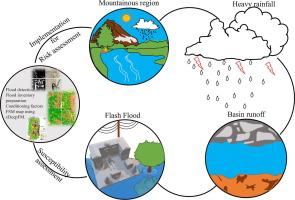
Flash floods (FFs) are amongst the most devastating hazards in arid regions in response to climate change and can cause the loss of agricultural land, human lives and infrastructure. One of the major challenges is the high-intensity rainfall events affecting low-lying areas that are vulnerable to FF. Several works in this field have been conducted using ensemble machine learning models and geohydrological models. However, the current advancement of eXtreme deep learning, which is named eXtreme deep factorisation machine (xDeepFM), for FF susceptibility mapping (FSM) is lacking in the literature. The current study introduces a new model and employs a previously unapplied approach to enhance FSM for capturing the severity of floods. The proposed approach has three main objectives: (i) During- and after-flood effects are assessed through flood detection techniques using Sentinel-1 data. (ii) Flood inventory is updated using remote sensing-based methods. The derived flood effects are implemented in the next step. (iii) An FSM map is generated using an xDeepFM model. Therefore, this study aims to apply xDeepFM to estimate susceptible areas using 13 factors in the emirates of Fujairah, UAE. The performance metrics show a recall of 0.9488), an F1-score of 0.9107), precision of (0.8756) and an overall accuracy of 90.41%. The accuracy of the applied xDeepFM model is compared with that of traditional machine learning models, specifically the deep neural network (78%), support vector machine (85.4%) and random forest (88.75%). Random forest achieves high accuracy, which is due to its strong performance that depends on factors contribution, dataset size and quality, and available computational resources. Comparatively, the xDeepFM model works efficiently for complicated prediction problems having high non-collinearity and huge datasets. The obtained map denotes that the narrow basins, lowland coastal areas and riverbank areas up to 5 km (Fujairah) are highly prone to FF, whilst the alluvial plains in Al Dhaid and hilly regions in Fujairah show low probability. The coastal city areas are bounded by high-rise steep hills and the Gulf of Oman, which can elevate the water levels during heavy rainfall. Four major synchronised influencing factors, namely, rainfall, elevation, drainage density, distance from drainage and geomorphology, account for nearly 50% of the total factors contributing to a very high flood susceptibility. This study offers a platform for planners and decision makers to take timely actions on potential areas in mitigating the effects of FF.
Geoscience frontiersEarth and Planetary Sciences-General Earth and Planetary Sciences
CiteScore
17.80
自引率
3.40%
发文量
147
审稿时长
35 days
期刊介绍:
Geoscience Frontiers (GSF) is the Journal of China University of Geosciences (Beijing) and Peking University. It publishes peer-reviewed research articles and reviews in interdisciplinary fields of Earth and Planetary Sciences. GSF covers various research areas including petrology and geochemistry, lithospheric architecture and mantle dynamics, global tectonics, economic geology and fuel exploration, geophysics, stratigraphy and paleontology, environmental and engineering geology, astrogeology, and the nexus of resources-energy-emissions-climate under Sustainable Development Goals. The journal aims to bridge innovative, provocative, and challenging concepts and models in these fields, providing insights on correlations and evolution.

 求助内容:
求助内容: 应助结果提醒方式:


