Sarah E. McCord, Nicholas P. Webb, Brandon T. Bestelmeyer, Kristopher Bonefont, Joseph R. Brehm, Joel Brown, Ericha M. Courtright, Chris Dietrich, Michael C. Duniway, Brandon Edwards, Christopher Fraser, Jeffrey E. Herrick, Anna C. Knight, Loretta Metz, Justin W. Van Zee, Craig Tweedie
{"title":"景观数据公共资源:用于农业生态系统研究和管理的大型环境数据集标准化、访问和应用系统","authors":"Sarah E. McCord, Nicholas P. Webb, Brandon T. Bestelmeyer, Kristopher Bonefont, Joseph R. Brehm, Joel Brown, Ericha M. Courtright, Chris Dietrich, Michael C. Duniway, Brandon Edwards, Christopher Fraser, Jeffrey E. Herrick, Anna C. Knight, Loretta Metz, Justin W. Van Zee, Craig Tweedie","doi":"10.1002/ael2.20120","DOIUrl":null,"url":null,"abstract":"<p>Understanding where, when, and why agroecosystems are changing requires quality information about ecosystems that span land tenure, ecological processes, and spatial scales. Over the past two decades, land management agencies and research groups have adopted a suite of standardized methods for monitoring rangelands, which have been implemented at over 85,000 monitoring locations globally. However, the ability to use these data to understand agroecosystem dynamics and change across scales and across land ownership has been limited because, until now, these data have not been available in a harmonized, accessible format for analyses, modeling, and decision-support tools. We present the Landscape Data Commons, a cyberinfrastructure platform that harmonizes and aggregates standardized agroecosystem data, enables linkages to models, and facilitates analysis and interpretation of data within decision-support tools. The Landscape Data Commons provides a community platform for users to contribute data and develop next-generation tools to support agroecosystem management through the 21st century.</p>","PeriodicalId":48502,"journal":{"name":"Agricultural & Environmental Letters","volume":"8 2","pages":""},"PeriodicalIF":3.6000,"publicationDate":"2023-12-10","publicationTypes":"Journal Article","fieldsOfStudy":null,"isOpenAccess":false,"openAccessPdf":"https://acsess.onlinelibrary.wiley.com/doi/epdf/10.1002/ael2.20120","citationCount":"0","resultStr":"{\"title\":\"The Landscape Data Commons: A system for standardizing, accessing, and applying large environmental datasets for agroecosystem research and management\",\"authors\":\"Sarah E. McCord, Nicholas P. Webb, Brandon T. Bestelmeyer, Kristopher Bonefont, Joseph R. Brehm, Joel Brown, Ericha M. Courtright, Chris Dietrich, Michael C. Duniway, Brandon Edwards, Christopher Fraser, Jeffrey E. Herrick, Anna C. Knight, Loretta Metz, Justin W. Van Zee, Craig Tweedie\",\"doi\":\"10.1002/ael2.20120\",\"DOIUrl\":null,\"url\":null,\"abstract\":\"<p>Understanding where, when, and why agroecosystems are changing requires quality information about ecosystems that span land tenure, ecological processes, and spatial scales. Over the past two decades, land management agencies and research groups have adopted a suite of standardized methods for monitoring rangelands, which have been implemented at over 85,000 monitoring locations globally. However, the ability to use these data to understand agroecosystem dynamics and change across scales and across land ownership has been limited because, until now, these data have not been available in a harmonized, accessible format for analyses, modeling, and decision-support tools. We present the Landscape Data Commons, a cyberinfrastructure platform that harmonizes and aggregates standardized agroecosystem data, enables linkages to models, and facilitates analysis and interpretation of data within decision-support tools. The Landscape Data Commons provides a community platform for users to contribute data and develop next-generation tools to support agroecosystem management through the 21st century.</p>\",\"PeriodicalId\":48502,\"journal\":{\"name\":\"Agricultural & Environmental Letters\",\"volume\":\"8 2\",\"pages\":\"\"},\"PeriodicalIF\":3.6000,\"publicationDate\":\"2023-12-10\",\"publicationTypes\":\"Journal Article\",\"fieldsOfStudy\":null,\"isOpenAccess\":false,\"openAccessPdf\":\"https://acsess.onlinelibrary.wiley.com/doi/epdf/10.1002/ael2.20120\",\"citationCount\":\"0\",\"resultStr\":null,\"platform\":\"Semanticscholar\",\"paperid\":null,\"PeriodicalName\":\"Agricultural & Environmental Letters\",\"FirstCategoryId\":\"97\",\"ListUrlMain\":\"https://onlinelibrary.wiley.com/doi/10.1002/ael2.20120\",\"RegionNum\":4,\"RegionCategory\":\"农林科学\",\"ArticlePicture\":[],\"TitleCN\":null,\"AbstractTextCN\":null,\"PMCID\":null,\"EPubDate\":\"\",\"PubModel\":\"\",\"JCR\":\"Q1\",\"JCRName\":\"AGRICULTURE, MULTIDISCIPLINARY\",\"Score\":null,\"Total\":0}","platform":"Semanticscholar","paperid":null,"PeriodicalName":"Agricultural & Environmental Letters","FirstCategoryId":"97","ListUrlMain":"https://onlinelibrary.wiley.com/doi/10.1002/ael2.20120","RegionNum":4,"RegionCategory":"农林科学","ArticlePicture":[],"TitleCN":null,"AbstractTextCN":null,"PMCID":null,"EPubDate":"","PubModel":"","JCR":"Q1","JCRName":"AGRICULTURE, MULTIDISCIPLINARY","Score":null,"Total":0}
The Landscape Data Commons: A system for standardizing, accessing, and applying large environmental datasets for agroecosystem research and management
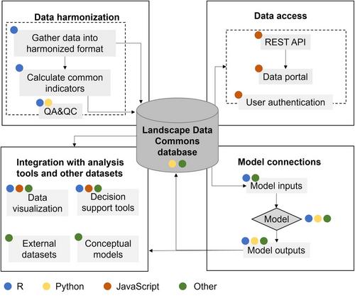
Understanding where, when, and why agroecosystems are changing requires quality information about ecosystems that span land tenure, ecological processes, and spatial scales. Over the past two decades, land management agencies and research groups have adopted a suite of standardized methods for monitoring rangelands, which have been implemented at over 85,000 monitoring locations globally. However, the ability to use these data to understand agroecosystem dynamics and change across scales and across land ownership has been limited because, until now, these data have not been available in a harmonized, accessible format for analyses, modeling, and decision-support tools. We present the Landscape Data Commons, a cyberinfrastructure platform that harmonizes and aggregates standardized agroecosystem data, enables linkages to models, and facilitates analysis and interpretation of data within decision-support tools. The Landscape Data Commons provides a community platform for users to contribute data and develop next-generation tools to support agroecosystem management through the 21st century.
 求助内容:
求助内容: 应助结果提醒方式:


