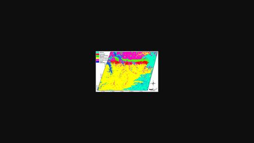
快速勘探碳酸盐岩及相关矿产资源的综合方法

IF 1.1 4区 地球科学 Q3 GEOLOGY
Resource Geology Pub Date : 2023-01-01 DOI:10.1111/rge.12321
Asad Khan, Muhammad Ali, Saad Khan, Zaheen Ullah, Shah Faisal, Laeiq Ahmad
{"title":"快速勘探碳酸盐岩及相关矿产资源的综合方法","authors":"Asad Khan, Muhammad Ali, Saad Khan, Zaheen Ullah, Shah Faisal, Laeiq Ahmad","doi":"10.1111/rge.12321","DOIUrl":null,"url":null,"abstract":"Abstract Carbonatites are proven significant repositories of several critical and strategic elements such as rare earth elements, niobium, thorium, and uranium. Owing to their economic significance, mapping of carbonatites and associated mineral deposits has occupied prominent place in mineral resource exploration programs. In this study an integrated approach was developed to map carbonatite and related mineral deposits in the Loe‐Shilman, Northwest Himalaya of Pakistan, using remotely sensed advance space‐borne thermal emission and reflection radiometer (ASTER) multispectral data and visible near infrared and short‐wave infrared (VNIR‐SWIR) spectral characteristics of minerals in these deposits. Several image enhancement techniques, including band ratio (i.e., B4/B3), principal component and minimum noise fraction transformation (PC6 and MNF5, respectively) helped in highlighting the targeted rocks. The results demonstrate the suitability of ASTER data for discriminating carbonatite related mineral deposits from other surrounding lithologies. Results obtained from these methods were validated through field observations in the area and further confirmed through petrographic and chemical analyses of collected specimens. Field data have also served as training data to perform a supervised classification, allowing further improvement of the mapping results. Moreover, the obtained results from the techniques used for exploring carbonatites and related mineral deposits were stacked together for comparison with each other, to check their sensitivities, and assess their efficiency and accuracy. Generally, all these methods successfully highlighted carbonatites and related mineral deposits; however, when used integratively they exhibit higher degree of accuracy, and has proven to be relatively rapid and cost‐effective.","PeriodicalId":21089,"journal":{"name":"Resource Geology","volume":"19 1","pages":"0"},"PeriodicalIF":1.1000,"publicationDate":"2023-01-01","publicationTypes":"Journal Article","fieldsOfStudy":null,"isOpenAccess":false,"openAccessPdf":"","citationCount":"0","resultStr":"{\"title\":\"An integrated approach for rapid exploration of carbonatites and related mineral resources\",\"authors\":\"Asad Khan, Muhammad Ali, Saad Khan, Zaheen Ullah, Shah Faisal, Laeiq Ahmad\",\"doi\":\"10.1111/rge.12321\",\"DOIUrl\":null,\"url\":null,\"abstract\":\"Abstract Carbonatites are proven significant repositories of several critical and strategic elements such as rare earth elements, niobium, thorium, and uranium. Owing to their economic significance, mapping of carbonatites and associated mineral deposits has occupied prominent place in mineral resource exploration programs. In this study an integrated approach was developed to map carbonatite and related mineral deposits in the Loe‐Shilman, Northwest Himalaya of Pakistan, using remotely sensed advance space‐borne thermal emission and reflection radiometer (ASTER) multispectral data and visible near infrared and short‐wave infrared (VNIR‐SWIR) spectral characteristics of minerals in these deposits. Several image enhancement techniques, including band ratio (i.e., B4/B3), principal component and minimum noise fraction transformation (PC6 and MNF5, respectively) helped in highlighting the targeted rocks. The results demonstrate the suitability of ASTER data for discriminating carbonatite related mineral deposits from other surrounding lithologies. Results obtained from these methods were validated through field observations in the area and further confirmed through petrographic and chemical analyses of collected specimens. Field data have also served as training data to perform a supervised classification, allowing further improvement of the mapping results. Moreover, the obtained results from the techniques used for exploring carbonatites and related mineral deposits were stacked together for comparison with each other, to check their sensitivities, and assess their efficiency and accuracy. Generally, all these methods successfully highlighted carbonatites and related mineral deposits; however, when used integratively they exhibit higher degree of accuracy, and has proven to be relatively rapid and cost‐effective.\",\"PeriodicalId\":21089,\"journal\":{\"name\":\"Resource Geology\",\"volume\":\"19 1\",\"pages\":\"0\"},\"PeriodicalIF\":1.1000,\"publicationDate\":\"2023-01-01\",\"publicationTypes\":\"Journal Article\",\"fieldsOfStudy\":null,\"isOpenAccess\":false,\"openAccessPdf\":\"\",\"citationCount\":\"0\",\"resultStr\":null,\"platform\":\"Semanticscholar\",\"paperid\":null,\"PeriodicalName\":\"Resource Geology\",\"FirstCategoryId\":\"1085\",\"ListUrlMain\":\"https://doi.org/10.1111/rge.12321\",\"RegionNum\":4,\"RegionCategory\":\"地球科学\",\"ArticlePicture\":[],\"TitleCN\":null,\"AbstractTextCN\":null,\"PMCID\":null,\"EPubDate\":\"\",\"PubModel\":\"\",\"JCR\":\"Q3\",\"JCRName\":\"GEOLOGY\",\"Score\":null,\"Total\":0}","platform":"Semanticscholar","paperid":null,"PeriodicalName":"Resource Geology","FirstCategoryId":"1085","ListUrlMain":"https://doi.org/10.1111/rge.12321","RegionNum":4,"RegionCategory":"地球科学","ArticlePicture":[],"TitleCN":null,"AbstractTextCN":null,"PMCID":null,"EPubDate":"","PubModel":"","JCR":"Q3","JCRName":"GEOLOGY","Score":null,"Total":0}
引用次数: 0

摘要

碳酸盐岩被证明是几种关键和战略元素的重要储存库,如稀土元素、铌、钍和铀。由于其经济意义,碳酸盐岩及其伴生矿床的测绘在矿产资源勘查中占有重要地位。在这项研究中,利用遥感先进的星载热发射和反射辐射计(ASTER)多光谱数据以及这些矿床中矿物的可见近红外和短波红外(VNIR - SWIR)光谱特征,开发了一种综合方法来绘制巴基斯坦喜马拉雅西北部Loe - Shilman的碳酸盐岩和相关矿床。几种图像增强技术,包括波段比(即B4/B3)、主成分和最小噪声分数变换(分别为PC6和MNF5),有助于突出目标岩石。结果表明,ASTER数据可用于碳酸盐岩相关矿床与周围其他岩性的鉴别。这些方法得到的结果通过该地区的实地观察得到验证,并通过收集标本的岩石学和化学分析得到进一步证实。现场数据也用作训练数据,以执行监督分类,从而进一步改进制图结果。此外,将碳酸盐岩和相关矿床勘探技术所得结果叠加在一起进行比较,以检查其灵敏度,并评估其效率和准确性。总的来说,所有这些方法都成功地突出了碳酸盐岩及其相关矿床;然而,当集成使用时,它们表现出更高的准确性,并且已被证明相对快速且具有成本效益。
本文章由计算机程序翻译,如有差异,请以英文原文为准。

An integrated approach for rapid exploration of carbonatites and related mineral resources

An integrated approach for rapid exploration of carbonatites and related mineral resources
Abstract Carbonatites are proven significant repositories of several critical and strategic elements such as rare earth elements, niobium, thorium, and uranium. Owing to their economic significance, mapping of carbonatites and associated mineral deposits has occupied prominent place in mineral resource exploration programs. In this study an integrated approach was developed to map carbonatite and related mineral deposits in the Loe‐Shilman, Northwest Himalaya of Pakistan, using remotely sensed advance space‐borne thermal emission and reflection radiometer (ASTER) multispectral data and visible near infrared and short‐wave infrared (VNIR‐SWIR) spectral characteristics of minerals in these deposits. Several image enhancement techniques, including band ratio (i.e., B4/B3), principal component and minimum noise fraction transformation (PC6 and MNF5, respectively) helped in highlighting the targeted rocks. The results demonstrate the suitability of ASTER data for discriminating carbonatite related mineral deposits from other surrounding lithologies. Results obtained from these methods were validated through field observations in the area and further confirmed through petrographic and chemical analyses of collected specimens. Field data have also served as training data to perform a supervised classification, allowing further improvement of the mapping results. Moreover, the obtained results from the techniques used for exploring carbonatites and related mineral deposits were stacked together for comparison with each other, to check their sensitivities, and assess their efficiency and accuracy. Generally, all these methods successfully highlighted carbonatites and related mineral deposits; however, when used integratively they exhibit higher degree of accuracy, and has proven to be relatively rapid and cost‐effective.
求助全文
通过发布文献求助,成功后即可免费获取论文全文。 去求助
来源期刊
Resource Geology
Resource Geology 地学-地质学
CiteScore
2.30
自引率
14.30%
发文量
18
审稿时长
12 months
期刊介绍: Resource Geology is an international journal focusing on economic geology, geochemistry and environmental geology. Its purpose is to contribute to the promotion of earth sciences related to metallic and non-metallic mineral deposits mainly in Asia, Oceania and the Circum-Pacific region, although other parts of the world are also considered. Launched in 1998 by the Society for Resource Geology, the journal is published quarterly in English, making it more accessible to the international geological community. The journal publishes high quality papers of interest to those engaged in research and exploration of mineral deposits.
×
引用
GB/T 7714-2015
复制
MLA
复制
APA
复制
导出至
BibTeX EndNote RefMan NoteFirst NoteExpress
×
提示
您的信息不完整,为了账户安全,请先补充。
现在去补充
×
提示
您因"违规操作"
具体请查看互助需知
我知道了
×
提示
确定
请完成安全验证×
copy
已复制链接
快去分享给好友吧!
我知道了
右上角分享
点击右上角分享
0
联系我们:info@booksci.cn Book学术提供免费学术资源搜索服务,方便国内外学者检索中英文文献。致力于提供最便捷和优质的服务体验。 Copyright © 2023 布克学术 All rights reserved.
京ICP备2023020795号-1
ghs 京公网安备 11010802042870号
Book学术文献互助
Book学术文献互助群
群 号:481959085
Book学术官方微信