{"title":"快速提供地图和火山学参数:通过多种遥感技术的整合对2021年埃特纳火山熔岩流进行量化","authors":"Cristina Proietti, Emanuela De Beni, Massimo Cantarero, Tullio Ricci, Gaetana Ganci","doi":"10.1007/s00445-023-01673-w","DOIUrl":null,"url":null,"abstract":"Abstract At active volcanoes recurring eruptive events, erosive processes and collapses modify the edifice morphology and impact monitoring and hazard mitigation. At Etna volcano (Italy) between February and October 2021, 57 paroxysmal events occurred from the South-East Crater (SEC), which is currently its most active summit crater. Strombolian activity and high lava fountains (up to 4 km) fed lava flows towards the east, south and south-west, and caused fallout of ballistics (greater than 1 m in diameter) within 1–2 km from the SEC. The impacted area does not include permanent infrastructure, but it is visited by thousands of tourists. Hence, we rapidly mapped each lava flow before deposits became covered by the next event, for hazard mitigation. The high frequency of the SEC paroxysms necessitated integration of data from three remote sensing platforms with different spatial resolutions. Satellite (Sentinel-2 MultiSpectral Instrument, PlanetScope, Skysat and Landsat-8 Operational Land Imager) and drone images (visible and thermal) were processed and integrated to extract digital surface models and orthomosaics. Thermal images acquired by a permanent network of cameras of the Istituto Nazionale di Geofisica e Vulcanologia were orthorectified using the latest available digital surface model. This multi-sensor analysis allowed compilation of a geodatabase reporting the main geometrical parameters for each lava flow. A posteriori analysis allowed quantification of bulk volumes for the lava flows and the SEC changes and of the dense rock equivalent volume of erupted magma. The analysis of drone-derived digital surface models enabled assessment of the ballistics’ distribution. The developed methodology enabled rapidly and accurate characterisation of frequently occurring effusive events for near real-time risk assessment and hazard communication.","PeriodicalId":55297,"journal":{"name":"Bulletin of Volcanology","volume":"50 1","pages":"0"},"PeriodicalIF":3.6000,"publicationDate":"2023-09-13","publicationTypes":"Journal Article","fieldsOfStudy":null,"isOpenAccess":false,"openAccessPdf":"","citationCount":"0","resultStr":"{\"title\":\"Rapid provision of maps and volcanological parameters: quantification of the 2021 Etna volcano lava flows through the integration of multiple remote sensing techniques\",\"authors\":\"Cristina Proietti, Emanuela De Beni, Massimo Cantarero, Tullio Ricci, Gaetana Ganci\",\"doi\":\"10.1007/s00445-023-01673-w\",\"DOIUrl\":null,\"url\":null,\"abstract\":\"Abstract At active volcanoes recurring eruptive events, erosive processes and collapses modify the edifice morphology and impact monitoring and hazard mitigation. At Etna volcano (Italy) between February and October 2021, 57 paroxysmal events occurred from the South-East Crater (SEC), which is currently its most active summit crater. Strombolian activity and high lava fountains (up to 4 km) fed lava flows towards the east, south and south-west, and caused fallout of ballistics (greater than 1 m in diameter) within 1–2 km from the SEC. The impacted area does not include permanent infrastructure, but it is visited by thousands of tourists. Hence, we rapidly mapped each lava flow before deposits became covered by the next event, for hazard mitigation. The high frequency of the SEC paroxysms necessitated integration of data from three remote sensing platforms with different spatial resolutions. Satellite (Sentinel-2 MultiSpectral Instrument, PlanetScope, Skysat and Landsat-8 Operational Land Imager) and drone images (visible and thermal) were processed and integrated to extract digital surface models and orthomosaics. Thermal images acquired by a permanent network of cameras of the Istituto Nazionale di Geofisica e Vulcanologia were orthorectified using the latest available digital surface model. This multi-sensor analysis allowed compilation of a geodatabase reporting the main geometrical parameters for each lava flow. A posteriori analysis allowed quantification of bulk volumes for the lava flows and the SEC changes and of the dense rock equivalent volume of erupted magma. The analysis of drone-derived digital surface models enabled assessment of the ballistics’ distribution. The developed methodology enabled rapidly and accurate characterisation of frequently occurring effusive events for near real-time risk assessment and hazard communication.\",\"PeriodicalId\":55297,\"journal\":{\"name\":\"Bulletin of Volcanology\",\"volume\":\"50 1\",\"pages\":\"0\"},\"PeriodicalIF\":3.6000,\"publicationDate\":\"2023-09-13\",\"publicationTypes\":\"Journal Article\",\"fieldsOfStudy\":null,\"isOpenAccess\":false,\"openAccessPdf\":\"\",\"citationCount\":\"0\",\"resultStr\":null,\"platform\":\"Semanticscholar\",\"paperid\":null,\"PeriodicalName\":\"Bulletin of Volcanology\",\"FirstCategoryId\":\"1085\",\"ListUrlMain\":\"https://doi.org/10.1007/s00445-023-01673-w\",\"RegionNum\":2,\"RegionCategory\":\"地球科学\",\"ArticlePicture\":[],\"TitleCN\":null,\"AbstractTextCN\":null,\"PMCID\":null,\"EPubDate\":\"\",\"PubModel\":\"\",\"JCR\":\"Q1\",\"JCRName\":\"GEOSCIENCES, MULTIDISCIPLINARY\",\"Score\":null,\"Total\":0}","platform":"Semanticscholar","paperid":null,"PeriodicalName":"Bulletin of Volcanology","FirstCategoryId":"1085","ListUrlMain":"https://doi.org/10.1007/s00445-023-01673-w","RegionNum":2,"RegionCategory":"地球科学","ArticlePicture":[],"TitleCN":null,"AbstractTextCN":null,"PMCID":null,"EPubDate":"","PubModel":"","JCR":"Q1","JCRName":"GEOSCIENCES, MULTIDISCIPLINARY","Score":null,"Total":0}
Rapid provision of maps and volcanological parameters: quantification of the 2021 Etna volcano lava flows through the integration of multiple remote sensing techniques
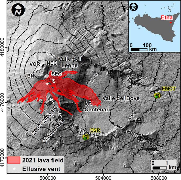
Abstract At active volcanoes recurring eruptive events, erosive processes and collapses modify the edifice morphology and impact monitoring and hazard mitigation. At Etna volcano (Italy) between February and October 2021, 57 paroxysmal events occurred from the South-East Crater (SEC), which is currently its most active summit crater. Strombolian activity and high lava fountains (up to 4 km) fed lava flows towards the east, south and south-west, and caused fallout of ballistics (greater than 1 m in diameter) within 1–2 km from the SEC. The impacted area does not include permanent infrastructure, but it is visited by thousands of tourists. Hence, we rapidly mapped each lava flow before deposits became covered by the next event, for hazard mitigation. The high frequency of the SEC paroxysms necessitated integration of data from three remote sensing platforms with different spatial resolutions. Satellite (Sentinel-2 MultiSpectral Instrument, PlanetScope, Skysat and Landsat-8 Operational Land Imager) and drone images (visible and thermal) were processed and integrated to extract digital surface models and orthomosaics. Thermal images acquired by a permanent network of cameras of the Istituto Nazionale di Geofisica e Vulcanologia were orthorectified using the latest available digital surface model. This multi-sensor analysis allowed compilation of a geodatabase reporting the main geometrical parameters for each lava flow. A posteriori analysis allowed quantification of bulk volumes for the lava flows and the SEC changes and of the dense rock equivalent volume of erupted magma. The analysis of drone-derived digital surface models enabled assessment of the ballistics’ distribution. The developed methodology enabled rapidly and accurate characterisation of frequently occurring effusive events for near real-time risk assessment and hazard communication.
期刊介绍:
Bulletin of Volcanology was founded in 1922, as Bulletin Volcanologique, and is the official journal of the International Association of Volcanology and Chemistry of the Earth’s Interior (IAVCEI). The Bulletin of Volcanology publishes papers on volcanoes, their products, their eruptive behavior, and their hazards. Papers aimed at understanding the deeper structure of volcanoes, and the evolution of magmatic systems using geochemical, petrological, and geophysical techniques are also published. Material is published in four sections: Review Articles; Research Articles; Short Scientific Communications; and a Forum that provides for discussion of controversial issues and for comment and reply on previously published Articles and Communications.