Rana Waqar Aslam , Hong Shu , Kanwal Javid , Shazia Pervaiz , Farhan Mustafa , Danish Raza , Bilal Ahmed , Abdul Quddoos , Saad Al-Ahmadi , Wesam Atef Hatamleh
{"title":"通过遥感识别湿地:对湿度、绿度、浊度、温度和变化景观的见解","authors":"Rana Waqar Aslam , Hong Shu , Kanwal Javid , Shazia Pervaiz , Farhan Mustafa , Danish Raza , Bilal Ahmed , Abdul Quddoos , Saad Al-Ahmadi , Wesam Atef Hatamleh","doi":"10.1016/j.bdr.2023.100416","DOIUrl":null,"url":null,"abstract":"<div><p>Wetlands are important in many ways, including hydrological cycles, ecosystem diversity, climate change, and economic activity. Despite the Ramsar Convention's awareness programmes, the importance of wetlands is frequently disregarded in underdeveloped countries. The Ramsar Convention recognises 2491 wetlands worldwide, 19 of which are in Pakistan. The goal of this study is to use satellite sensor technology to identify neglected wetlands in Pakistan. The key goals of this research are to analyse water quality, monitor ecological changes, and comprehend the impact of climate change on the aforementioned wetlands. We used approaches like supervised classification and TCW to identify wetlands. To detect climate-induced changes, a change detection index was used to Quick Bird imagery. TCG and the NDTI were also employed to examine the water quality and ecological changes in these wetlands. Sentinel-2 data between 2016 and 2019 were used in the analysis. Furthermore, watershed analysis was carried out using ASTER DEM data. Modis data was used to calculate the LST (°C) of the selected wetlands, while rainfall (mm) data was collected from ANN databases. According to the study's findings, in 2016, Borith, Phander, Upper Kachura, Satpara, and Rama Lake held 22.73%, 20.79%, 23.01%, 24.63%, and 23.03% water, respectively. In 2019, the water ratios for these lakes were 23.40%, 22.10%, 22.43%, 25.01%, and 24.56%. These findings emphasise the need of taking preventative actions to protect these wetlands in order to improve ecosystem dynamics in the future. As a result, it is critical that the relevant authorities implement the necessary conservation measures.</p></div>","PeriodicalId":56017,"journal":{"name":"Big Data Research","volume":"35 ","pages":"Article 100416"},"PeriodicalIF":4.2000,"publicationDate":"2023-11-09","publicationTypes":"Journal Article","fieldsOfStudy":null,"isOpenAccess":false,"openAccessPdf":"https://www.sciencedirect.com/science/article/pii/S2214579623000497/pdfft?md5=6c2fd850b51a67adc45a9dc630b4afe6&pid=1-s2.0-S2214579623000497-main.pdf","citationCount":"0","resultStr":"{\"title\":\"Wetland identification through remote sensing: Insights into wetness, greenness, turbidity, temperature, and changing landscapes\",\"authors\":\"Rana Waqar Aslam , Hong Shu , Kanwal Javid , Shazia Pervaiz , Farhan Mustafa , Danish Raza , Bilal Ahmed , Abdul Quddoos , Saad Al-Ahmadi , Wesam Atef Hatamleh\",\"doi\":\"10.1016/j.bdr.2023.100416\",\"DOIUrl\":null,\"url\":null,\"abstract\":\"<div><p>Wetlands are important in many ways, including hydrological cycles, ecosystem diversity, climate change, and economic activity. Despite the Ramsar Convention's awareness programmes, the importance of wetlands is frequently disregarded in underdeveloped countries. The Ramsar Convention recognises 2491 wetlands worldwide, 19 of which are in Pakistan. The goal of this study is to use satellite sensor technology to identify neglected wetlands in Pakistan. The key goals of this research are to analyse water quality, monitor ecological changes, and comprehend the impact of climate change on the aforementioned wetlands. We used approaches like supervised classification and TCW to identify wetlands. To detect climate-induced changes, a change detection index was used to Quick Bird imagery. TCG and the NDTI were also employed to examine the water quality and ecological changes in these wetlands. Sentinel-2 data between 2016 and 2019 were used in the analysis. Furthermore, watershed analysis was carried out using ASTER DEM data. Modis data was used to calculate the LST (°C) of the selected wetlands, while rainfall (mm) data was collected from ANN databases. According to the study's findings, in 2016, Borith, Phander, Upper Kachura, Satpara, and Rama Lake held 22.73%, 20.79%, 23.01%, 24.63%, and 23.03% water, respectively. In 2019, the water ratios for these lakes were 23.40%, 22.10%, 22.43%, 25.01%, and 24.56%. These findings emphasise the need of taking preventative actions to protect these wetlands in order to improve ecosystem dynamics in the future. As a result, it is critical that the relevant authorities implement the necessary conservation measures.</p></div>\",\"PeriodicalId\":56017,\"journal\":{\"name\":\"Big Data Research\",\"volume\":\"35 \",\"pages\":\"Article 100416\"},\"PeriodicalIF\":4.2000,\"publicationDate\":\"2023-11-09\",\"publicationTypes\":\"Journal Article\",\"fieldsOfStudy\":null,\"isOpenAccess\":false,\"openAccessPdf\":\"https://www.sciencedirect.com/science/article/pii/S2214579623000497/pdfft?md5=6c2fd850b51a67adc45a9dc630b4afe6&pid=1-s2.0-S2214579623000497-main.pdf\",\"citationCount\":\"0\",\"resultStr\":null,\"platform\":\"Semanticscholar\",\"paperid\":null,\"PeriodicalName\":\"Big Data Research\",\"FirstCategoryId\":\"94\",\"ListUrlMain\":\"https://www.sciencedirect.com/science/article/pii/S2214579623000497\",\"RegionNum\":3,\"RegionCategory\":\"计算机科学\",\"ArticlePicture\":[],\"TitleCN\":null,\"AbstractTextCN\":null,\"PMCID\":null,\"EPubDate\":\"\",\"PubModel\":\"\",\"JCR\":\"Q2\",\"JCRName\":\"COMPUTER SCIENCE, ARTIFICIAL INTELLIGENCE\",\"Score\":null,\"Total\":0}","platform":"Semanticscholar","paperid":null,"PeriodicalName":"Big Data Research","FirstCategoryId":"94","ListUrlMain":"https://www.sciencedirect.com/science/article/pii/S2214579623000497","RegionNum":3,"RegionCategory":"计算机科学","ArticlePicture":[],"TitleCN":null,"AbstractTextCN":null,"PMCID":null,"EPubDate":"","PubModel":"","JCR":"Q2","JCRName":"COMPUTER SCIENCE, ARTIFICIAL INTELLIGENCE","Score":null,"Total":0}
Wetland identification through remote sensing: Insights into wetness, greenness, turbidity, temperature, and changing landscapes
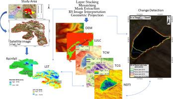
Wetlands are important in many ways, including hydrological cycles, ecosystem diversity, climate change, and economic activity. Despite the Ramsar Convention's awareness programmes, the importance of wetlands is frequently disregarded in underdeveloped countries. The Ramsar Convention recognises 2491 wetlands worldwide, 19 of which are in Pakistan. The goal of this study is to use satellite sensor technology to identify neglected wetlands in Pakistan. The key goals of this research are to analyse water quality, monitor ecological changes, and comprehend the impact of climate change on the aforementioned wetlands. We used approaches like supervised classification and TCW to identify wetlands. To detect climate-induced changes, a change detection index was used to Quick Bird imagery. TCG and the NDTI were also employed to examine the water quality and ecological changes in these wetlands. Sentinel-2 data between 2016 and 2019 were used in the analysis. Furthermore, watershed analysis was carried out using ASTER DEM data. Modis data was used to calculate the LST (°C) of the selected wetlands, while rainfall (mm) data was collected from ANN databases. According to the study's findings, in 2016, Borith, Phander, Upper Kachura, Satpara, and Rama Lake held 22.73%, 20.79%, 23.01%, 24.63%, and 23.03% water, respectively. In 2019, the water ratios for these lakes were 23.40%, 22.10%, 22.43%, 25.01%, and 24.56%. These findings emphasise the need of taking preventative actions to protect these wetlands in order to improve ecosystem dynamics in the future. As a result, it is critical that the relevant authorities implement the necessary conservation measures.
期刊介绍:
The journal aims to promote and communicate advances in big data research by providing a fast and high quality forum for researchers, practitioners and policy makers from the very many different communities working on, and with, this topic.
The journal will accept papers on foundational aspects in dealing with big data, as well as papers on specific Platforms and Technologies used to deal with big data. To promote Data Science and interdisciplinary collaboration between fields, and to showcase the benefits of data driven research, papers demonstrating applications of big data in domains as diverse as Geoscience, Social Web, Finance, e-Commerce, Health Care, Environment and Climate, Physics and Astronomy, Chemistry, life sciences and drug discovery, digital libraries and scientific publications, security and government will also be considered. Occasionally the journal may publish whitepapers on policies, standards and best practices.
 求助内容:
求助内容: 应助结果提醒方式:


