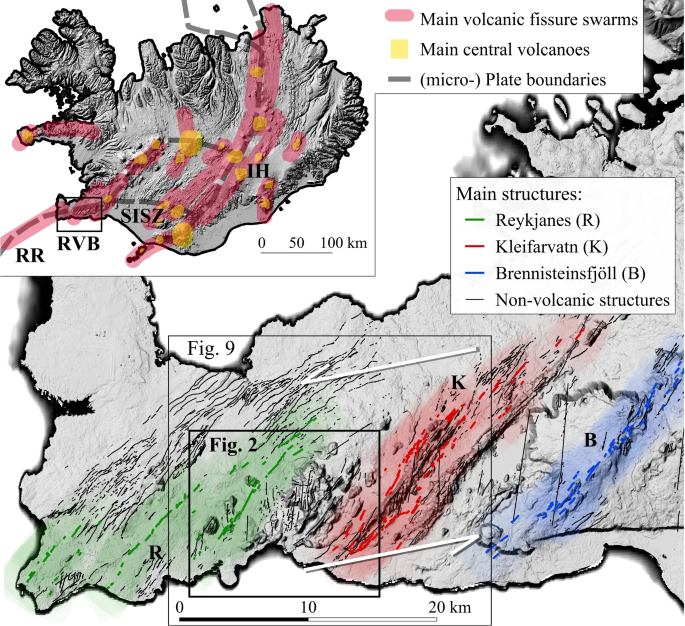
2021年Reykjanes斜裂事件(冰岛西南部)期间产生的地表裂缝

IF 3.6 2区 地球科学 Q1 GEOSCIENCES, MULTIDISCIPLINARY
Simon Bufféral, Elisabetta Panza, Stefano Mannini, Ásta Rut Hjartardóttir, Adriano Nobile, Nils Gies, Birgir Vilhelm Óskarsson, Joël Ruch
{"title":"2021年Reykjanes斜裂事件(冰岛西南部)期间产生的地表裂缝","authors":"Simon Bufféral, Elisabetta Panza, Stefano Mannini, Ásta Rut Hjartardóttir, Adriano Nobile, Nils Gies, Birgir Vilhelm Óskarsson, Joël Ruch","doi":"10.1007/s00445-023-01666-9","DOIUrl":null,"url":null,"abstract":"Abstract We use a comprehensive dataset of field observations, high spatial resolution drone orthomosaics and digital terrain models (DTMs) to map, quantify and characterize the extensive ground fracturing related to the 2021 seismo-tectonic and volcanic activity in the Reykjanes Peninsula (Iceland). The dataset, spans an area of about 30 km $$^2$$ <mml:math xmlns:mml=\"http://www.w3.org/1998/Math/MathML\"> <mml:msup> <mml:mrow /> <mml:mn>2</mml:mn> </mml:msup> </mml:math> , where we map nearly 20 000 ground cracks with metric to decametric lengths and centimetric extensional offsets, revealing a dominant dextral shear, in agreement with published seismic data. Although striking in a direction similar to the volcanic systems in the Reykjanes Peninsula (N030–040), most fractures appear as en-échelon structures globally aligned along N-S-striking fault zones up to 3–4 km long. By examining the timing of ground fracturing through repeated field observations, seismic data and InSAR images, we associate a fracture zone with most earthquakes of M $$_\\omega \\ge 5.0$$ <mml:math xmlns:mml=\"http://www.w3.org/1998/Math/MathML\"> <mml:mrow> <mml:msub> <mml:mrow /> <mml:mi>ω</mml:mi> </mml:msub> <mml:mo>≥</mml:mo> <mml:mn>5.0</mml:mn> </mml:mrow> </mml:math> that occurred in the month preceding the March 2021 Fagradalsfjall eruption. We describe three preexisting N-S fault zones, with fault segments that were reactivated up to three times during the pre-eruptive seismic activity, while the magma intrusion did not trigger graben-related ground fractures typically observed during magmatic injections. Our depiction of a system dominated by strike-slip tectonic features helps in understanding the geometry and bookshelf-mode of tectonic activity along a diffuse and highly oblique extensional plate boundary. Evidence of transient fracturing is typically quickly lost because of erosion or lava flow burial, highlighting a potential under-representation of diffuse fracturing when studying old tectonic and volcanic systems.","PeriodicalId":55297,"journal":{"name":"Bulletin of Volcanology","volume":"7 1","pages":"0"},"PeriodicalIF":3.6000,"publicationDate":"2023-10-21","publicationTypes":"Journal Article","fieldsOfStudy":null,"isOpenAccess":false,"openAccessPdf":"","citationCount":"0","resultStr":"{\"title\":\"Surface fractures generated during the 2021 Reykjanes oblique rifting event (SW Iceland)\",\"authors\":\"Simon Bufféral, Elisabetta Panza, Stefano Mannini, Ásta Rut Hjartardóttir, Adriano Nobile, Nils Gies, Birgir Vilhelm Óskarsson, Joël Ruch\",\"doi\":\"10.1007/s00445-023-01666-9\",\"DOIUrl\":null,\"url\":null,\"abstract\":\"Abstract We use a comprehensive dataset of field observations, high spatial resolution drone orthomosaics and digital terrain models (DTMs) to map, quantify and characterize the extensive ground fracturing related to the 2021 seismo-tectonic and volcanic activity in the Reykjanes Peninsula (Iceland). The dataset, spans an area of about 30 km $$^2$$ <mml:math xmlns:mml=\\\"http://www.w3.org/1998/Math/MathML\\\"> <mml:msup> <mml:mrow /> <mml:mn>2</mml:mn> </mml:msup> </mml:math> , where we map nearly 20 000 ground cracks with metric to decametric lengths and centimetric extensional offsets, revealing a dominant dextral shear, in agreement with published seismic data. Although striking in a direction similar to the volcanic systems in the Reykjanes Peninsula (N030–040), most fractures appear as en-échelon structures globally aligned along N-S-striking fault zones up to 3–4 km long. By examining the timing of ground fracturing through repeated field observations, seismic data and InSAR images, we associate a fracture zone with most earthquakes of M $$_\\\\omega \\\\ge 5.0$$ <mml:math xmlns:mml=\\\"http://www.w3.org/1998/Math/MathML\\\"> <mml:mrow> <mml:msub> <mml:mrow /> <mml:mi>ω</mml:mi> </mml:msub> <mml:mo>≥</mml:mo> <mml:mn>5.0</mml:mn> </mml:mrow> </mml:math> that occurred in the month preceding the March 2021 Fagradalsfjall eruption. We describe three preexisting N-S fault zones, with fault segments that were reactivated up to three times during the pre-eruptive seismic activity, while the magma intrusion did not trigger graben-related ground fractures typically observed during magmatic injections. Our depiction of a system dominated by strike-slip tectonic features helps in understanding the geometry and bookshelf-mode of tectonic activity along a diffuse and highly oblique extensional plate boundary. Evidence of transient fracturing is typically quickly lost because of erosion or lava flow burial, highlighting a potential under-representation of diffuse fracturing when studying old tectonic and volcanic systems.\",\"PeriodicalId\":55297,\"journal\":{\"name\":\"Bulletin of Volcanology\",\"volume\":\"7 1\",\"pages\":\"0\"},\"PeriodicalIF\":3.6000,\"publicationDate\":\"2023-10-21\",\"publicationTypes\":\"Journal Article\",\"fieldsOfStudy\":null,\"isOpenAccess\":false,\"openAccessPdf\":\"\",\"citationCount\":\"0\",\"resultStr\":null,\"platform\":\"Semanticscholar\",\"paperid\":null,\"PeriodicalName\":\"Bulletin of Volcanology\",\"FirstCategoryId\":\"1085\",\"ListUrlMain\":\"https://doi.org/10.1007/s00445-023-01666-9\",\"RegionNum\":2,\"RegionCategory\":\"地球科学\",\"ArticlePicture\":[],\"TitleCN\":null,\"AbstractTextCN\":null,\"PMCID\":null,\"EPubDate\":\"\",\"PubModel\":\"\",\"JCR\":\"Q1\",\"JCRName\":\"GEOSCIENCES, MULTIDISCIPLINARY\",\"Score\":null,\"Total\":0}","platform":"Semanticscholar","paperid":null,"PeriodicalName":"Bulletin of Volcanology","FirstCategoryId":"1085","ListUrlMain":"https://doi.org/10.1007/s00445-023-01666-9","RegionNum":2,"RegionCategory":"地球科学","ArticlePicture":[],"TitleCN":null,"AbstractTextCN":null,"PMCID":null,"EPubDate":"","PubModel":"","JCR":"Q1","JCRName":"GEOSCIENCES, MULTIDISCIPLINARY","Score":null,"Total":0}
引用次数: 0

摘要

利用野外观测数据、高空间分辨率无人机正测图和数字地形模型(dtm)的综合数据集,对冰岛雷克雅内斯半岛2021年地震构造和火山活动相关的大面积地面压裂进行了制图、量化和表征。该数据集的面积约为30公里$$^2$$ 2,我们在其中绘制了近2万个地面裂缝,长度为公制至十公制,伸展偏移量为厘米制,揭示了一个主要的右向剪切,与已公布的地震数据一致。虽然断裂的方向与雷克雅内斯半岛(N030-040)的火山系统相似,但大多数断裂在全球范围内呈现出沿南北走向的断裂带排列的网状结构,最长可达3-4公里。通过重复的现场观测、地震数据和InSAR图像来检查地面破裂的时间,我们将裂缝带与发生在2021年3月Fagradalsfjall火山喷发前一个月的大多数M $$_\omega \ge 5.0$$ ω≥5.0级地震联系起来。我们描述了三个先前存在的N-S断裂带,其中断裂带在爆发前地震活动期间被重新激活了三次,而岩浆侵入并没有引发岩浆注入期间通常观察到的与地堑相关的地面裂缝。我们对一个以走滑构造特征为主导的系统的描述,有助于理解沿扩散和高度斜向伸展板块边界的构造活动的几何形状和书架模式。瞬态压裂的证据通常会因为侵蚀或熔岩流掩埋而迅速消失,这凸显了在研究古老的构造和火山系统时,弥漫性压裂的潜在代表性不足。
本文章由计算机程序翻译,如有差异,请以英文原文为准。

Surface fractures generated during the 2021 Reykjanes oblique rifting event (SW Iceland)

Surface fractures generated during the 2021 Reykjanes oblique rifting event (SW Iceland)
Abstract We use a comprehensive dataset of field observations, high spatial resolution drone orthomosaics and digital terrain models (DTMs) to map, quantify and characterize the extensive ground fracturing related to the 2021 seismo-tectonic and volcanic activity in the Reykjanes Peninsula (Iceland). The dataset, spans an area of about 30 km $$^2$$ 2 , where we map nearly 20 000 ground cracks with metric to decametric lengths and centimetric extensional offsets, revealing a dominant dextral shear, in agreement with published seismic data. Although striking in a direction similar to the volcanic systems in the Reykjanes Peninsula (N030–040), most fractures appear as en-échelon structures globally aligned along N-S-striking fault zones up to 3–4 km long. By examining the timing of ground fracturing through repeated field observations, seismic data and InSAR images, we associate a fracture zone with most earthquakes of M $$_\omega \ge 5.0$$ ω 5.0 that occurred in the month preceding the March 2021 Fagradalsfjall eruption. We describe three preexisting N-S fault zones, with fault segments that were reactivated up to three times during the pre-eruptive seismic activity, while the magma intrusion did not trigger graben-related ground fractures typically observed during magmatic injections. Our depiction of a system dominated by strike-slip tectonic features helps in understanding the geometry and bookshelf-mode of tectonic activity along a diffuse and highly oblique extensional plate boundary. Evidence of transient fracturing is typically quickly lost because of erosion or lava flow burial, highlighting a potential under-representation of diffuse fracturing when studying old tectonic and volcanic systems.
求助全文
通过发布文献求助,成功后即可免费获取论文全文。 去求助
来源期刊
Bulletin of Volcanology
Bulletin of Volcanology 地学-地球科学综合
CiteScore
6.40
自引率
20.00%
发文量
89
审稿时长
4-8 weeks
期刊介绍: Bulletin of Volcanology was founded in 1922, as Bulletin Volcanologique, and is the official journal of the International Association of Volcanology and Chemistry of the Earth’s Interior (IAVCEI). The Bulletin of Volcanology publishes papers on volcanoes, their products, their eruptive behavior, and their hazards. Papers aimed at understanding the deeper structure of volcanoes, and the evolution of magmatic systems using geochemical, petrological, and geophysical techniques are also published. Material is published in four sections: Review Articles; Research Articles; Short Scientific Communications; and a Forum that provides for discussion of controversial issues and for comment and reply on previously published Articles and Communications.
×
引用
GB/T 7714-2015
复制
MLA
复制
APA
复制
导出至
BibTeX EndNote RefMan NoteFirst NoteExpress
×
提示
您的信息不完整,为了账户安全,请先补充。
现在去补充
×
提示
您因"违规操作"
具体请查看互助需知
我知道了
×
提示
确定
请完成安全验证×
copy
已复制链接
快去分享给好友吧!
我知道了
右上角分享
点击右上角分享
0
联系我们:info@booksci.cn Book学术提供免费学术资源搜索服务,方便国内外学者检索中英文文献。致力于提供最便捷和优质的服务体验。 Copyright © 2023 布克学术 All rights reserved.
京ICP备2023020795号-1
ghs 京公网安备 11010802042870号
Book学术文献互助
Book学术文献互助群
群 号:481959085
Book学术官方微信