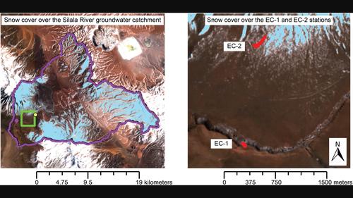
希拉拉河流域水文模拟。2. 用当代数据验证水文通量

IF 6.8 1区 地球科学 Q1 ENVIRONMENTAL SCIENCES
Gonzalo Yáñez‐Morroni, Francisco Suárez, José F. Muñoz, Magdalena Sofía Lagos
{"title":"希拉拉河流域水文模拟。2. 用当代数据验证水文通量","authors":"Gonzalo Yáñez‐Morroni, Francisco Suárez, José F. Muñoz, Magdalena Sofía Lagos","doi":"10.1002/wat2.1696","DOIUrl":null,"url":null,"abstract":"Abstract A companion paper in this Special Issue reviewed the development of a hydrological model of the Silala River basin, using long‐term data (1969–1992) to determine the basin's water balance and plausible groundwater recharge scenarios. In the context of a remote river basin with limited in situ data, this article reviews the potential of in situ and remotely collected data, available for a relatively short period (2018–2019), to validate various aspects of the hydrological model performance. These include the spatiotemporal evolution of snow cover areal fraction (SCF), actual evapotranspiration (ET a ) in the basin's extensive alluvial deposits, and wetland ET a . The observed SCF dynamics are well represented by the model at annual and monthly timescales, with monthly mean simulated SCF biases between −5.6% and 8%. At daily timescales, the model successfully captures snowstorm occurrence, although there are limitations on snow spatial patterning. Simulated ET a over alluvial deposits agrees with in situ observations during periods of high ET a , although the simulated values underestimate site‐specific observations during low ET a periods, due to the presence of lateral subsurface flows. In the wetlands, satellite‐based ET a estimates follow the seasonal pattern of in situ observations, but with values ~50% higher than those determined from elevation‐corrected eddy‐covariance (EC) measurements. Nonetheless, this difference is within the expected precision of the remote sensing method. Although based on a limited period, the validation results are encouraging, and demonstrate the utility of satellite tools and limited period in situ data for watersheds with scarce long‐term data. This article is categorized under: Science of Water > Hydrological Processes","PeriodicalId":23774,"journal":{"name":"Wiley Interdisciplinary Reviews: Water","volume":"30 1","pages":"0"},"PeriodicalIF":6.8000,"publicationDate":"2023-10-22","publicationTypes":"Journal Article","fieldsOfStudy":null,"isOpenAccess":false,"openAccessPdf":"","citationCount":"3","resultStr":"{\"title\":\"Hydrological modeling of the Silala River basin. 2. Validation of hydrological fluxes with contemporary data\",\"authors\":\"Gonzalo Yáñez‐Morroni, Francisco Suárez, José F. Muñoz, Magdalena Sofía Lagos\",\"doi\":\"10.1002/wat2.1696\",\"DOIUrl\":null,\"url\":null,\"abstract\":\"Abstract A companion paper in this Special Issue reviewed the development of a hydrological model of the Silala River basin, using long‐term data (1969–1992) to determine the basin's water balance and plausible groundwater recharge scenarios. In the context of a remote river basin with limited in situ data, this article reviews the potential of in situ and remotely collected data, available for a relatively short period (2018–2019), to validate various aspects of the hydrological model performance. These include the spatiotemporal evolution of snow cover areal fraction (SCF), actual evapotranspiration (ET a ) in the basin's extensive alluvial deposits, and wetland ET a . The observed SCF dynamics are well represented by the model at annual and monthly timescales, with monthly mean simulated SCF biases between −5.6% and 8%. At daily timescales, the model successfully captures snowstorm occurrence, although there are limitations on snow spatial patterning. Simulated ET a over alluvial deposits agrees with in situ observations during periods of high ET a , although the simulated values underestimate site‐specific observations during low ET a periods, due to the presence of lateral subsurface flows. In the wetlands, satellite‐based ET a estimates follow the seasonal pattern of in situ observations, but with values ~50% higher than those determined from elevation‐corrected eddy‐covariance (EC) measurements. Nonetheless, this difference is within the expected precision of the remote sensing method. Although based on a limited period, the validation results are encouraging, and demonstrate the utility of satellite tools and limited period in situ data for watersheds with scarce long‐term data. This article is categorized under: Science of Water > Hydrological Processes\",\"PeriodicalId\":23774,\"journal\":{\"name\":\"Wiley Interdisciplinary Reviews: Water\",\"volume\":\"30 1\",\"pages\":\"0\"},\"PeriodicalIF\":6.8000,\"publicationDate\":\"2023-10-22\",\"publicationTypes\":\"Journal Article\",\"fieldsOfStudy\":null,\"isOpenAccess\":false,\"openAccessPdf\":\"\",\"citationCount\":\"3\",\"resultStr\":null,\"platform\":\"Semanticscholar\",\"paperid\":null,\"PeriodicalName\":\"Wiley Interdisciplinary Reviews: Water\",\"FirstCategoryId\":\"1085\",\"ListUrlMain\":\"https://doi.org/10.1002/wat2.1696\",\"RegionNum\":1,\"RegionCategory\":\"地球科学\",\"ArticlePicture\":[],\"TitleCN\":null,\"AbstractTextCN\":null,\"PMCID\":null,\"EPubDate\":\"\",\"PubModel\":\"\",\"JCR\":\"Q1\",\"JCRName\":\"ENVIRONMENTAL SCIENCES\",\"Score\":null,\"Total\":0}","platform":"Semanticscholar","paperid":null,"PeriodicalName":"Wiley Interdisciplinary Reviews: Water","FirstCategoryId":"1085","ListUrlMain":"https://doi.org/10.1002/wat2.1696","RegionNum":1,"RegionCategory":"地球科学","ArticlePicture":[],"TitleCN":null,"AbstractTextCN":null,"PMCID":null,"EPubDate":"","PubModel":"","JCR":"Q1","JCRName":"ENVIRONMENTAL SCIENCES","Score":null,"Total":0}
引用次数: 3

摘要

本期特刊的另一篇论文回顾了西拉拉河流域水文模型的发展,该模型使用1969-1992年的长期数据来确定流域的水平衡和合理的地下水补给情景。在现场数据有限的偏远河流流域的背景下,本文回顾了在相对较短的时间内(2018-2019)可获得的现场和远程收集数据的潜力,以验证水文模型性能的各个方面。其中包括积雪面积分数(SCF)的时空演变、流域广泛冲积沉积物的实际蒸散发(ET a)和湿地ET a。在年和月的时间尺度上,模型很好地反映了观测到的SCF动态,月平均模拟SCF偏差在- 5.6%到8%之间。在日时间尺度上,该模式成功地捕获了暴风雪的发生,尽管在雪的空间模式上存在局限性。冲积沉积物上模拟的ET a与高ET a时期的现场观测值一致,尽管由于侧向地下流的存在,模拟值低估了低ET a时期特定地点的观测值。在湿地,基于卫星的ET a估计值遵循现场观测的季节模式,但其值比由高程校正的涡动协方差(EC)测量值高约50%。尽管如此,这种差异仍在遥感方法的预期精度范围内。虽然基于有限的时期,但验证结果令人鼓舞,并证明了卫星工具和有限时期的原位数据对缺乏长期数据的流域的效用。本文分类如下:水科学;水文过程
本文章由计算机程序翻译,如有差异,请以英文原文为准。

Hydrological modeling of the Silala River basin. 2. Validation of hydrological fluxes with contemporary data

Hydrological modeling of the Silala River basin. 2. Validation of hydrological fluxes with contemporary data
Abstract A companion paper in this Special Issue reviewed the development of a hydrological model of the Silala River basin, using long‐term data (1969–1992) to determine the basin's water balance and plausible groundwater recharge scenarios. In the context of a remote river basin with limited in situ data, this article reviews the potential of in situ and remotely collected data, available for a relatively short period (2018–2019), to validate various aspects of the hydrological model performance. These include the spatiotemporal evolution of snow cover areal fraction (SCF), actual evapotranspiration (ET a ) in the basin's extensive alluvial deposits, and wetland ET a . The observed SCF dynamics are well represented by the model at annual and monthly timescales, with monthly mean simulated SCF biases between −5.6% and 8%. At daily timescales, the model successfully captures snowstorm occurrence, although there are limitations on snow spatial patterning. Simulated ET a over alluvial deposits agrees with in situ observations during periods of high ET a , although the simulated values underestimate site‐specific observations during low ET a periods, due to the presence of lateral subsurface flows. In the wetlands, satellite‐based ET a estimates follow the seasonal pattern of in situ observations, but with values ~50% higher than those determined from elevation‐corrected eddy‐covariance (EC) measurements. Nonetheless, this difference is within the expected precision of the remote sensing method. Although based on a limited period, the validation results are encouraging, and demonstrate the utility of satellite tools and limited period in situ data for watersheds with scarce long‐term data. This article is categorized under: Science of Water > Hydrological Processes
求助全文
通过发布文献求助,成功后即可免费获取论文全文。 去求助
来源期刊
Wiley Interdisciplinary Reviews: Water
Wiley Interdisciplinary Reviews: Water Environmental Science-Ecology
CiteScore
16.60
自引率
3.70%
发文量
56
期刊介绍: The WIREs series is truly unique, blending the best aspects of encyclopedic reference works and review journals into a dynamic online format. These remarkable resources foster a research culture that transcends disciplinary boundaries, all while upholding the utmost scientific and presentation excellence. However, they go beyond traditional publications and are, in essence, ever-evolving databases of the latest cutting-edge reviews.
×
引用
GB/T 7714-2015
复制
MLA
复制
APA
复制
导出至
BibTeX EndNote RefMan NoteFirst NoteExpress
×
提示
您的信息不完整,为了账户安全,请先补充。
现在去补充
×
提示
您因"违规操作"
具体请查看互助需知
我知道了
×
提示
确定
请完成安全验证×
copy
已复制链接
快去分享给好友吧!
我知道了
右上角分享
点击右上角分享
0
联系我们:info@booksci.cn Book学术提供免费学术资源搜索服务,方便国内外学者检索中英文文献。致力于提供最便捷和优质的服务体验。 Copyright © 2023 布克学术 All rights reserved.
京ICP备2023020795号-1
ghs 京公网安备 11010802042870号
Book学术文献互助
Book学术文献互助群
群 号:481959085
Book学术官方微信