Jan Bryan M. Encabo, Marcos R. C. Cordeiro, Nasem Badreldin, Emma J. McGeough, David Walker
{"title":"加拿大马尼托巴省公共草地土地覆被分类遥感清单评估","authors":"Jan Bryan M. Encabo, Marcos R. C. Cordeiro, Nasem Badreldin, Emma J. McGeough, David Walker","doi":"10.1111/gfs.12631","DOIUrl":null,"url":null,"abstract":"<p>Land cover classification is one of the most common applications of remote sensing and is used for developing and modifying land management policies on agricultural landscapes to achieve conservation and economic goals, such as reducing grassland degradation and improving livestock and crop production. In this study, the grassland classification of the crown lands (public grasslands in Canada) from a newly developed remotely sensed dataset in the Prairie Province of Manitoba (i.e., the Manitoba Grassland Inventory, MGI) was assessed in terms of accuracy by comparison to non-spatial government records. The analysis consisted of (i) converting non-spatial records from the provincial crown land database to spatially-defined parcels by performing parcel delineations using geographic information system (GIS) and R programming tools, (ii) summarising the MGI classification at the same spatial scale, and (iii) comparing the agreement between MGI and the crown land database. The most common land cover types identified were: forest (30%) and shrubland (25%), followed by native (10%) and tame (9%) grasslands. However, the class agreements between woody (i.e., forests and shrublands) and grassy (i.e., native and tame grasslands) vegetation classes were low between these datasets because of their spectral similarities. Based on these results, we suggest additional refinements on both sensor and ground data to improve the classification agreement between these datasets. This study is one of the first attempts to compare ground-collected government records against a remotely sensed product in Manitoba.</p>","PeriodicalId":12767,"journal":{"name":"Grass and Forage Science","volume":"78 4","pages":"590-601"},"PeriodicalIF":2.7000,"publicationDate":"2023-10-25","publicationTypes":"Journal Article","fieldsOfStudy":null,"isOpenAccess":false,"openAccessPdf":"https://onlinelibrary.wiley.com/doi/epdf/10.1111/gfs.12631","citationCount":"0","resultStr":"{\"title\":\"Assessment of remotely sensed inventories for land cover classification of public grasslands in Manitoba, Canada\",\"authors\":\"Jan Bryan M. Encabo, Marcos R. C. Cordeiro, Nasem Badreldin, Emma J. McGeough, David Walker\",\"doi\":\"10.1111/gfs.12631\",\"DOIUrl\":null,\"url\":null,\"abstract\":\"<p>Land cover classification is one of the most common applications of remote sensing and is used for developing and modifying land management policies on agricultural landscapes to achieve conservation and economic goals, such as reducing grassland degradation and improving livestock and crop production. In this study, the grassland classification of the crown lands (public grasslands in Canada) from a newly developed remotely sensed dataset in the Prairie Province of Manitoba (i.e., the Manitoba Grassland Inventory, MGI) was assessed in terms of accuracy by comparison to non-spatial government records. The analysis consisted of (i) converting non-spatial records from the provincial crown land database to spatially-defined parcels by performing parcel delineations using geographic information system (GIS) and R programming tools, (ii) summarising the MGI classification at the same spatial scale, and (iii) comparing the agreement between MGI and the crown land database. The most common land cover types identified were: forest (30%) and shrubland (25%), followed by native (10%) and tame (9%) grasslands. However, the class agreements between woody (i.e., forests and shrublands) and grassy (i.e., native and tame grasslands) vegetation classes were low between these datasets because of their spectral similarities. Based on these results, we suggest additional refinements on both sensor and ground data to improve the classification agreement between these datasets. This study is one of the first attempts to compare ground-collected government records against a remotely sensed product in Manitoba.</p>\",\"PeriodicalId\":12767,\"journal\":{\"name\":\"Grass and Forage Science\",\"volume\":\"78 4\",\"pages\":\"590-601\"},\"PeriodicalIF\":2.7000,\"publicationDate\":\"2023-10-25\",\"publicationTypes\":\"Journal Article\",\"fieldsOfStudy\":null,\"isOpenAccess\":false,\"openAccessPdf\":\"https://onlinelibrary.wiley.com/doi/epdf/10.1111/gfs.12631\",\"citationCount\":\"0\",\"resultStr\":null,\"platform\":\"Semanticscholar\",\"paperid\":null,\"PeriodicalName\":\"Grass and Forage Science\",\"FirstCategoryId\":\"97\",\"ListUrlMain\":\"https://onlinelibrary.wiley.com/doi/10.1111/gfs.12631\",\"RegionNum\":3,\"RegionCategory\":\"农林科学\",\"ArticlePicture\":[],\"TitleCN\":null,\"AbstractTextCN\":null,\"PMCID\":null,\"EPubDate\":\"\",\"PubModel\":\"\",\"JCR\":\"Q1\",\"JCRName\":\"AGRONOMY\",\"Score\":null,\"Total\":0}","platform":"Semanticscholar","paperid":null,"PeriodicalName":"Grass and Forage Science","FirstCategoryId":"97","ListUrlMain":"https://onlinelibrary.wiley.com/doi/10.1111/gfs.12631","RegionNum":3,"RegionCategory":"农林科学","ArticlePicture":[],"TitleCN":null,"AbstractTextCN":null,"PMCID":null,"EPubDate":"","PubModel":"","JCR":"Q1","JCRName":"AGRONOMY","Score":null,"Total":0}
Assessment of remotely sensed inventories for land cover classification of public grasslands in Manitoba, Canada
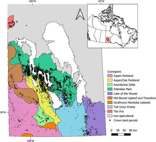
Land cover classification is one of the most common applications of remote sensing and is used for developing and modifying land management policies on agricultural landscapes to achieve conservation and economic goals, such as reducing grassland degradation and improving livestock and crop production. In this study, the grassland classification of the crown lands (public grasslands in Canada) from a newly developed remotely sensed dataset in the Prairie Province of Manitoba (i.e., the Manitoba Grassland Inventory, MGI) was assessed in terms of accuracy by comparison to non-spatial government records. The analysis consisted of (i) converting non-spatial records from the provincial crown land database to spatially-defined parcels by performing parcel delineations using geographic information system (GIS) and R programming tools, (ii) summarising the MGI classification at the same spatial scale, and (iii) comparing the agreement between MGI and the crown land database. The most common land cover types identified were: forest (30%) and shrubland (25%), followed by native (10%) and tame (9%) grasslands. However, the class agreements between woody (i.e., forests and shrublands) and grassy (i.e., native and tame grasslands) vegetation classes were low between these datasets because of their spectral similarities. Based on these results, we suggest additional refinements on both sensor and ground data to improve the classification agreement between these datasets. This study is one of the first attempts to compare ground-collected government records against a remotely sensed product in Manitoba.
期刊介绍:
Grass and Forage Science is a major English language journal that publishes the results of research and development in all aspects of grass and forage production, management and utilization; reviews of the state of knowledge on relevant topics; and book reviews. Authors are also invited to submit papers on non-agricultural aspects of grassland management such as recreational and amenity use and the environmental implications of all grassland systems. The Journal considers papers from all climatic zones.
 求助内容:
求助内容: 应助结果提醒方式:


