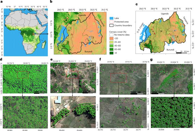
绘制卢旺达全国范围的树木地上碳储量图

IF 29.6 1区 地球科学 Q1 ENVIRONMENTAL SCIENCES
Maurice Mugabowindekwe, Martin Brandt, Jérôme Chave, Florian Reiner, David L. Skole, Ankit Kariryaa, Christian Igel, Pierre Hiernaux, Philippe Ciais, Ole Mertz, Xiaoye Tong, Sizhuo Li, Gaspard Rwanyiziri, Thaulin Dushimiyimana, Alain Ndoli, Valens Uwizeyimana, Jens-Peter Barnekow Lillesø, Fabian Gieseke, Compton J. Tucker, Sassan Saatchi, Rasmus Fensholt
{"title":"绘制卢旺达全国范围的树木地上碳储量图","authors":"Maurice Mugabowindekwe, Martin Brandt, Jérôme Chave, Florian Reiner, David L. Skole, Ankit Kariryaa, Christian Igel, Pierre Hiernaux, Philippe Ciais, Ole Mertz, Xiaoye Tong, Sizhuo Li, Gaspard Rwanyiziri, Thaulin Dushimiyimana, Alain Ndoli, Valens Uwizeyimana, Jens-Peter Barnekow Lillesø, Fabian Gieseke, Compton J. Tucker, Sassan Saatchi, Rasmus Fensholt","doi":"10.1038/s41558-022-01544-w","DOIUrl":null,"url":null,"abstract":"Trees sustain livelihoods and mitigate climate change but a predominance of trees outside forests and limited resources make it difficult for many tropical countries to conduct automated nation-wide inventories. Here, we propose an approach to map the carbon stock of each individual overstory tree at the national scale of Rwanda using aerial imagery from 2008 and deep learning. We show that 72% of the mapped trees are located in farmlands and savannas and 17% in plantations, accounting for 48.6% of the national aboveground carbon stocks. Natural forests cover 11% of the total tree count and 51.4% of the national carbon stocks, with an overall carbon stock uncertainty of 16.9%. The mapping of all trees allows partitioning to any landscapes classification and is urgently needed for effective planning and monitoring of restoration activities as well as for optimization of carbon sequestration, biodiversity and economic benefits of trees. The authors conduct a national inventory on individual tree carbon stocks in Rwanda using aerial imagery and deep learning. Most mapped trees are located in farmlands; new methods allow partitioning to any landscape categories, effective planning and optimization of carbon sequestration and the economic benefits of trees.","PeriodicalId":18974,"journal":{"name":"Nature Climate Change","volume":"13 1","pages":"91-97"},"PeriodicalIF":29.6000,"publicationDate":"2022-12-22","publicationTypes":"Journal Article","fieldsOfStudy":null,"isOpenAccess":false,"openAccessPdf":"https://www.ncbi.nlm.nih.gov/pmc/articles/PMC9845119/pdf/","citationCount":"15","resultStr":"{\"title\":\"Nation-wide mapping of tree-level aboveground carbon stocks in Rwanda\",\"authors\":\"Maurice Mugabowindekwe, Martin Brandt, Jérôme Chave, Florian Reiner, David L. Skole, Ankit Kariryaa, Christian Igel, Pierre Hiernaux, Philippe Ciais, Ole Mertz, Xiaoye Tong, Sizhuo Li, Gaspard Rwanyiziri, Thaulin Dushimiyimana, Alain Ndoli, Valens Uwizeyimana, Jens-Peter Barnekow Lillesø, Fabian Gieseke, Compton J. Tucker, Sassan Saatchi, Rasmus Fensholt\",\"doi\":\"10.1038/s41558-022-01544-w\",\"DOIUrl\":null,\"url\":null,\"abstract\":\"Trees sustain livelihoods and mitigate climate change but a predominance of trees outside forests and limited resources make it difficult for many tropical countries to conduct automated nation-wide inventories. Here, we propose an approach to map the carbon stock of each individual overstory tree at the national scale of Rwanda using aerial imagery from 2008 and deep learning. We show that 72% of the mapped trees are located in farmlands and savannas and 17% in plantations, accounting for 48.6% of the national aboveground carbon stocks. Natural forests cover 11% of the total tree count and 51.4% of the national carbon stocks, with an overall carbon stock uncertainty of 16.9%. The mapping of all trees allows partitioning to any landscapes classification and is urgently needed for effective planning and monitoring of restoration activities as well as for optimization of carbon sequestration, biodiversity and economic benefits of trees. The authors conduct a national inventory on individual tree carbon stocks in Rwanda using aerial imagery and deep learning. Most mapped trees are located in farmlands; new methods allow partitioning to any landscape categories, effective planning and optimization of carbon sequestration and the economic benefits of trees.\",\"PeriodicalId\":18974,\"journal\":{\"name\":\"Nature Climate Change\",\"volume\":\"13 1\",\"pages\":\"91-97\"},\"PeriodicalIF\":29.6000,\"publicationDate\":\"2022-12-22\",\"publicationTypes\":\"Journal Article\",\"fieldsOfStudy\":null,\"isOpenAccess\":false,\"openAccessPdf\":\"https://www.ncbi.nlm.nih.gov/pmc/articles/PMC9845119/pdf/\",\"citationCount\":\"15\",\"resultStr\":null,\"platform\":\"Semanticscholar\",\"paperid\":null,\"PeriodicalName\":\"Nature Climate Change\",\"FirstCategoryId\":\"89\",\"ListUrlMain\":\"https://www.nature.com/articles/s41558-022-01544-w\",\"RegionNum\":1,\"RegionCategory\":\"地球科学\",\"ArticlePicture\":[],\"TitleCN\":null,\"AbstractTextCN\":null,\"PMCID\":null,\"EPubDate\":\"\",\"PubModel\":\"\",\"JCR\":\"Q1\",\"JCRName\":\"ENVIRONMENTAL SCIENCES\",\"Score\":null,\"Total\":0}","platform":"Semanticscholar","paperid":null,"PeriodicalName":"Nature Climate Change","FirstCategoryId":"89","ListUrlMain":"https://www.nature.com/articles/s41558-022-01544-w","RegionNum":1,"RegionCategory":"地球科学","ArticlePicture":[],"TitleCN":null,"AbstractTextCN":null,"PMCID":null,"EPubDate":"","PubModel":"","JCR":"Q1","JCRName":"ENVIRONMENTAL SCIENCES","Score":null,"Total":0}
引用次数: 15

摘要

树木可以维持生计并减缓气候变化,但由于森林外的树木居多且资源有限,许多热带国家很难在全国范围内进行自动清查。在此,我们提出了一种方法,利用 2008 年的航拍图像和深度学习,绘制卢旺达全国范围内每棵上层树木的碳储量图。我们的研究表明,72% 的绘图树木位于农田和热带草原,17% 位于种植园,占全国地上碳储量的 48.6%。天然林占树木总数的 11%,占全国碳储量的 51.4%,总体碳储量的不确定性为 16.9%。绘制所有树木的分布图可以根据任何地貌分类进行分区,这对于有效规划和监测恢复活动以及优化碳固存、生物多样性和树木的经济效益都是迫切需要的。作者利用航拍图像和深度学习对卢旺达的树木碳储量进行了全国性清查。大多数绘制的树木位于农田中;新方法可将树木划分为任何地貌类别,有效规划和优化碳固存以及树木的经济效益。
本文章由计算机程序翻译,如有差异,请以英文原文为准。

Nation-wide mapping of tree-level aboveground carbon stocks in Rwanda

Nation-wide mapping of tree-level aboveground carbon stocks in Rwanda
Trees sustain livelihoods and mitigate climate change but a predominance of trees outside forests and limited resources make it difficult for many tropical countries to conduct automated nation-wide inventories. Here, we propose an approach to map the carbon stock of each individual overstory tree at the national scale of Rwanda using aerial imagery from 2008 and deep learning. We show that 72% of the mapped trees are located in farmlands and savannas and 17% in plantations, accounting for 48.6% of the national aboveground carbon stocks. Natural forests cover 11% of the total tree count and 51.4% of the national carbon stocks, with an overall carbon stock uncertainty of 16.9%. The mapping of all trees allows partitioning to any landscapes classification and is urgently needed for effective planning and monitoring of restoration activities as well as for optimization of carbon sequestration, biodiversity and economic benefits of trees. The authors conduct a national inventory on individual tree carbon stocks in Rwanda using aerial imagery and deep learning. Most mapped trees are located in farmlands; new methods allow partitioning to any landscape categories, effective planning and optimization of carbon sequestration and the economic benefits of trees.
求助全文
通过发布文献求助,成功后即可免费获取论文全文。 去求助
来源期刊
Nature Climate Change
Nature Climate Change ENVIRONMENTAL SCIENCES-METEOROLOGY & ATMOSPHERIC SCIENCES
CiteScore
40.30
自引率
1.60%
发文量
267
审稿时长
4-8 weeks
期刊介绍: Nature Climate Change is dedicated to addressing the scientific challenge of understanding Earth's changing climate and its societal implications. As a monthly journal, it publishes significant and cutting-edge research on the nature, causes, and impacts of global climate change, as well as its implications for the economy, policy, and the world at large. The journal publishes original research spanning the natural and social sciences, synthesizing interdisciplinary research to provide a comprehensive understanding of climate change. It upholds the high standards set by all Nature-branded journals, ensuring top-tier original research through a fair and rigorous review process, broad readership access, high standards of copy editing and production, rapid publication, and independence from academic societies and other vested interests. Nature Climate Change serves as a platform for discussion among experts, publishing opinion, analysis, and review articles. It also features Research Highlights to highlight important developments in the field and original reporting from renowned science journalists in the form of feature articles. Topics covered in the journal include adaptation, atmospheric science, ecology, economics, energy, impacts and vulnerability, mitigation, oceanography, policy, sociology, and sustainability, among others.
×
引用
GB/T 7714-2015
复制
MLA
复制
APA
复制
导出至
BibTeX EndNote RefMan NoteFirst NoteExpress
×
提示
您的信息不完整,为了账户安全,请先补充。
现在去补充
×
提示
您因"违规操作"
具体请查看互助需知
我知道了
×
提示
确定
请完成安全验证×
copy
已复制链接
快去分享给好友吧!
我知道了
右上角分享
点击右上角分享
0
联系我们:info@booksci.cn Book学术提供免费学术资源搜索服务,方便国内外学者检索中英文文献。致力于提供最便捷和优质的服务体验。 Copyright © 2023 布克学术 All rights reserved.
京ICP备2023020795号-1
ghs 京公网安备 11010802042870号
Book学术文献互助
Book学术文献互助群
群 号:481959085
Book学术官方微信