{"title":"Impact assessment of river bank erosion in the lower part of Mahanadi River using geospatial sciences","authors":"Raj Hossain Mallick, Jatisankar Bandyopadhyay, Bijay Halder","doi":"10.1016/j.horiz.2023.100075","DOIUrl":null,"url":null,"abstract":"<div><p>The river bank erosion is gradually changing landscape in river and riverine areas. Therefore, assessment of the exact uncovering and altering of the various river features aspects is more essential. The current analysis is dedicated to river bank erosion (RBE) on lower part of the Mahanadi River (Odisha) using Remote Sensing (RS) and GIS applications. The Mahanadi River basin is more dynamic and affects the neighborhood landscape. The difficulties of river bank areas are indirectly or directly associated with bank erosion, this usually produces lots of challenges like landslides, flood hazards, flood inundation, and land alteration. Landsat imageries are applied to extract erosional locations and land alteration by applying satellite datasets and geospatial software like ArcGIS software v10.8 and ERDAS Imagine v2014. Erosion rate variations were measured through the <em>Erase</em> tool by applying GIS methods. The lower part of Mahanadi River has changed all selected parts like 1091 ha (A), 1245 ha (B), and 646 ha (C), while the accretion areas are like 865 ha (A), 1204 ha (B), and 812 ha (C) correspondingly. The vegetation gradually decreased (3241 ha) while the cropland increased (1541 ha), while the river sand is observed at 1374 ha (1991) and 1727 ha (221) in the investigated area. The most affected villages are Patugadadharpur, Dankarisahi, Rasanga, Karabar, Badabanpur, Gopa, Gopinathpur, and Samapurdal. Therefore, the erosion or accretion activities are triggering landscape change over the examining location. These outcomes help to prepare for future disaster management, building awareness, novel adaptation strategies, and planning purposes.</p></div>","PeriodicalId":101199,"journal":{"name":"Sustainable Horizons","volume":"8 ","pages":"Article 100075"},"PeriodicalIF":0.0000,"publicationDate":"2023-10-27","publicationTypes":"Journal Article","fieldsOfStudy":null,"isOpenAccess":false,"openAccessPdf":"https://www.sciencedirect.com/science/article/pii/S2772737823000299/pdfft?md5=591b9f0e893019849e3e7f049bf9302e&pid=1-s2.0-S2772737823000299-main.pdf","citationCount":"0","resultStr":null,"platform":"Semanticscholar","paperid":null,"PeriodicalName":"Sustainable Horizons","FirstCategoryId":"1085","ListUrlMain":"https://www.sciencedirect.com/science/article/pii/S2772737823000299","RegionNum":0,"RegionCategory":null,"ArticlePicture":[],"TitleCN":null,"AbstractTextCN":null,"PMCID":null,"EPubDate":"","PubModel":"","JCR":"","JCRName":"","Score":null,"Total":0}
引用次数: 0
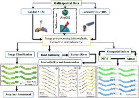
Abstract
The river bank erosion is gradually changing landscape in river and riverine areas. Therefore, assessment of the exact uncovering and altering of the various river features aspects is more essential. The current analysis is dedicated to river bank erosion (RBE) on lower part of the Mahanadi River (Odisha) using Remote Sensing (RS) and GIS applications. The Mahanadi River basin is more dynamic and affects the neighborhood landscape. The difficulties of river bank areas are indirectly or directly associated with bank erosion, this usually produces lots of challenges like landslides, flood hazards, flood inundation, and land alteration. Landsat imageries are applied to extract erosional locations and land alteration by applying satellite datasets and geospatial software like ArcGIS software v10.8 and ERDAS Imagine v2014. Erosion rate variations were measured through the Erase tool by applying GIS methods. The lower part of Mahanadi River has changed all selected parts like 1091 ha (A), 1245 ha (B), and 646 ha (C), while the accretion areas are like 865 ha (A), 1204 ha (B), and 812 ha (C) correspondingly. The vegetation gradually decreased (3241 ha) while the cropland increased (1541 ha), while the river sand is observed at 1374 ha (1991) and 1727 ha (221) in the investigated area. The most affected villages are Patugadadharpur, Dankarisahi, Rasanga, Karabar, Badabanpur, Gopa, Gopinathpur, and Samapurdal. Therefore, the erosion or accretion activities are triggering landscape change over the examining location. These outcomes help to prepare for future disaster management, building awareness, novel adaptation strategies, and planning purposes.
河岸侵蚀正逐渐改变着河流流域的景观。因此,准确评估河流各特征方面的揭示和变化就显得尤为重要。目前的分析是利用遥感(RS)和地理信息系统应用于马哈纳迪河(奥里萨邦)下游的河岸侵蚀(RBE)。Mahanadi河流域更具活力,影响着周边景观。河岸地区的困难直接或间接地与河岸侵蚀有关,河岸侵蚀通常会产生山体滑坡、洪涝灾害、洪水淹没、土地变更等诸多挑战。利用卫星数据集和ArcGIS v10.8、ERDAS Imagine v2014等地理空间软件,利用Landsat影像提取侵蚀位置和土地蚀变。利用GIS方法,通过Erase工具测量侵蚀速率变化。Mahanadi河下游的选择区分别为1091 ha (A)、1245 ha (B)和646 ha (C),而吸积区分别为865 ha (A)、1204 ha (B)和812 ha (C)。调查区植被逐渐减少(3241 ha),耕地逐渐增加(1541 ha),河沙面积分别为1374 ha(1991)和1727 ha(221)。受影响最严重的村庄是Patugadadharpur、Dankarisahi、Rasanga、Karabar、Badabanpur、Gopa、Gopinathpur和Samapurdal。因此,侵蚀或增生活动正在引发研究地点的景观变化。这些成果有助于为未来的灾害管理、提高认识、制定新的适应战略和规划目标做好准备。

 求助内容:
求助内容: 应助结果提醒方式:


