Review on geology and mineralization of North Korea (II: Phanerozoic)
IF 0.8
4区 地球科学
Q3 GEOLOGY
引用次数: 1
Abstract
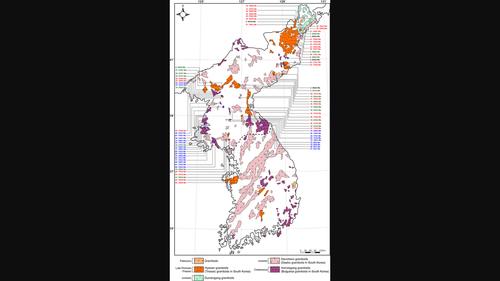
In this review, we attempted to summarize and interpret the Phanerozoic geology and mineralization following the article (vol. 71 in Resource Geology) which reviewed the Precambrian geology and mineralization of North Korea. The basement of the Korean peninsula was built during the Precambrian and gradually became more evolved and complex during the Phanerozoic. The northern part of the peninsula was in the active and passive continental margins of the Korea–China platform during the Phanerozoic. In the tectonic environments of the Phanerozoic, the tectonic provinces of North Korea comprise several Paleozoic–Mesozoic intracontinental and rift basins as well as Cenozoic ocean border and rift basins. During the Paleozoic, the sedimentary strata were formed within the marine‐to‐nonmarine intracontinental basins, such as the largest Pyeongnam and Hyesan–Iwon basin, Imjingang rift basin, and several small structural basins, and the sedimentary type of limestone, dolomite, and coal deposits were formed. Mesozoic orogenic events in the peninsula were the most overwhelming geologic event causing block movements through collision and subduction of the paleo‐Pacific plate. Songrim orogeny (late Permian to early Triassic) might be caused by continental collision associated with strong deformation, metamorphism, and granite intrusion. Daebo orogeny (Jurassic) resumed the crustal deformation under a contractional setting during the subduction and caused dextral ductile shearing, magmatism, and metamorphism in the entire peninsula. Amnokgang orogeny, corresponding to Bulguksa orogeny in South Korea, during the Cretaceous formed several pull‐apart or transtensional basins probably because of oblique subduction of the Izanagi plate, and nonmarine sedimentary and pyroclastic sequences were deposited in the basin. The mineralization related to the Mesozoic plutonism was the most dominant in the peninsula. The considerable mineral deposits are ultramafic related magmatic Ni deposits owing to rift magmatism and granite related hydrothermal Au–Ag, Cu, Pb–Zn, Fe, W, and Mo deposits caused by the subduction of paleo‐Pacific plate. During the Tertiary, several structural basins under the extensional regime were overprinted on the Mesozoic basins in the northern part of the peninsula. They contain marine and nonmarine sedimentary rocks and felsic–mafic extrusives. Some sedimentary deposits, such as coal, kaolin, bentonite, diatomite, and zeolite, were formed. The Tertiary Pohang basin in South Korea shows basin geology, magmatism, and mineralization similar to those of North Korea. The Phanerozoic geotectonics of the peninsula are characterized by the evolution of the structural basins and violent magmatism. The peninsula is located on the Amur plate, bounded by the Philippine plate, Pacific plate, and Eurasian plate. Since Phanerozoic, the peninsula's geographic position created an important tectonic link between northeastern China and the Japanese Islands throughout geotectonic evolution.

朝鲜地质与成矿作用评述(II:显生宙)
本文继《资源地质》第71卷评述朝鲜前寒武纪地质与成矿作用的文章之后,试图对显生宙地质与成矿作用进行总结和解释。朝鲜半岛的基底形成于前寒武纪,显生宙逐渐演化和复杂。显生宙期间,半岛北部处于韩中地台的主动和被动大陆边缘。在显生宙的构造环境中,朝鲜的构造省包括几个古生代-中生代陆内盆地和裂谷盆地,以及新生代洋界盆地和裂谷盆地。古生代沉积地层形成于海相—非海相陆内盆地,如最大的平南盆地、惠山—益原盆地、临津江裂谷盆地和几个小型构造盆地,形成了沉积类型为灰岩、白云岩和煤炭矿床。半岛中生代造山事件是古太平洋板块碰撞和俯冲引起地块运动的最具压倒性的地质事件。松林造山运动(晚二叠世至早三叠世)可能是由大陆碰撞引起的,并伴有强烈的变形、变质作用和花岗岩侵入。大宝造山运动(侏罗纪)恢复了俯冲过程中收缩环境下的地壳变形,引起了整个半岛的右旋韧性剪切、岩浆作用和变质作用。白垩纪与韩国Bulguksa造山运动相对应的神仙岗造山运动,可能是由于伊扎那吉板块的斜向俯冲,形成了多个拉分或张拉盆地,并沉积了非海相沉积和火山碎屑层序。以中生代深部成矿作用为主。主要矿床为裂谷岩浆作用形成的超镁铁质岩浆型镍矿床和古太平洋板块俯冲作用形成的花岗岩型热液型Au-Ag、Cu、Pb-Zn、Fe、W、Mo矿床。第三纪时期,几个伸展构造盆地叠加在半岛北部中生代盆地之上。它们含有海相和非海相沉积岩以及长质-镁质挤出物。形成了一些沉积矿床,如煤、高岭土、膨润土、硅藻土和沸石。韩国浦项盆地第三系的盆地地质、岩浆作用和成矿作用与朝鲜相似。半岛显生宙大地构造以构造盆地的演化和剧烈的岩浆活动为特征。半岛位于阿穆尔河板块上,与菲律宾板块、太平洋板块和欧亚板块接壤。显生宙以来,半岛的地理位置在整个大地构造演化过程中形成了连接中国东北与日本列岛的重要构造纽带。
本文章由计算机程序翻译,如有差异,请以英文原文为准。
求助全文
约1分钟内获得全文
求助全文
来源期刊

Resource Geology
地学-地质学
CiteScore
2.30
自引率
14.30%
发文量
18
审稿时长
12 months
期刊介绍:
Resource Geology is an international journal focusing on economic geology, geochemistry and environmental geology. Its purpose is to contribute to the promotion of earth sciences related to metallic and non-metallic mineral deposits mainly in Asia, Oceania and the Circum-Pacific region, although other parts of the world are also considered.
Launched in 1998 by the Society for Resource Geology, the journal is published quarterly in English, making it more accessible to the international geological community. The journal publishes high quality papers of interest to those engaged in research and exploration of mineral deposits.
 求助内容:
求助内容: 应助结果提醒方式:


