Ishwer Datt Gupta, Vincent W. Lee, Mihailo D. Trifunac
{"title":"Seismic microzoning of the Delhi metropolitan area, India—II: Hazard computation and zoning maps","authors":"Ishwer Datt Gupta, Vincent W. Lee, Mihailo D. Trifunac","doi":"10.1002/eer2.15","DOIUrl":null,"url":null,"abstract":"<p>We present seismic microzonation maps of New Delhi, India, using the probabilistic seismic hazard analysis (PSHA) method with input seismic activity parameters estimated in Part-I of this two-part paper. Our calculations required three different attenuation equations for amplitude scaling of strong ground motion from three principal contributing sources: the National Capital Region (NCR), Northwestern Himalaya (NWH), and the Hindu Kush subduction (HKS). We show that uniform hazard spectral (UHS) amplitudes are dominated only by the local seismicity in the NCR at high frequencies beyond about 2 Hz. For intermediate and long periods, UHS amplitudes are dominated by contributions from the NWH and HKS earthquakes. Our results show that specifying strong motion amplitudes for use in engineering design by means of peak ground acceleration can lead to serious errors for buildings higher than four to five stories and hence should not be used. Our results also show that the shape of design spectra must depend on the nature of contributing earthquake sources, their relative activity, potential to create large magnitudes, and geographical placement relative to the site of interest, and thus a standard design-spectrum shape cannot satisfy all these requirements. We use local geological site condition parameters directly in all calculations and present hazard maps for three different soil site conditions (“rock,” stiff soil sites, and deep soil sites). Thus, the user can extract the UHS amplitudes of pseudo relative velocity spectra at any site in the National Capital Territory by experimentally determining the local soil site conditions and then applying the corresponding maps shown in this paper.</p>","PeriodicalId":100383,"journal":{"name":"Earthquake Engineering and Resilience","volume":"1 2","pages":"138-163"},"PeriodicalIF":1.9000,"publicationDate":"2022-08-08","publicationTypes":"Journal Article","fieldsOfStudy":null,"isOpenAccess":false,"openAccessPdf":"https://onlinelibrary.wiley.com/doi/epdf/10.1002/eer2.15","citationCount":"3","resultStr":null,"platform":"Semanticscholar","paperid":null,"PeriodicalName":"Earthquake Engineering and Resilience","FirstCategoryId":"1085","ListUrlMain":"https://onlinelibrary.wiley.com/doi/10.1002/eer2.15","RegionNum":0,"RegionCategory":null,"ArticlePicture":[],"TitleCN":null,"AbstractTextCN":null,"PMCID":null,"EPubDate":"","PubModel":"","JCR":"","JCRName":"","Score":null,"Total":0}
引用次数: 3
Abstract
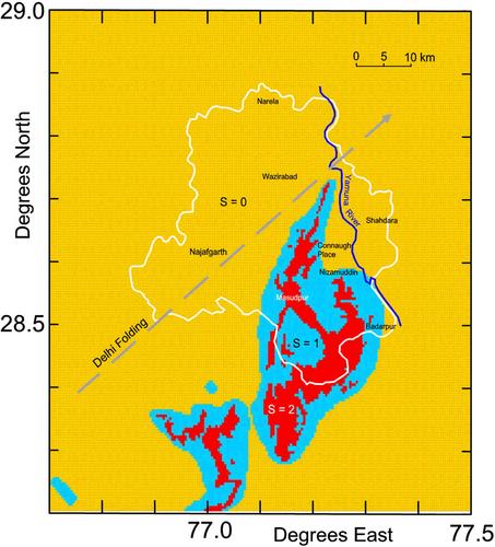
We present seismic microzonation maps of New Delhi, India, using the probabilistic seismic hazard analysis (PSHA) method with input seismic activity parameters estimated in Part-I of this two-part paper. Our calculations required three different attenuation equations for amplitude scaling of strong ground motion from three principal contributing sources: the National Capital Region (NCR), Northwestern Himalaya (NWH), and the Hindu Kush subduction (HKS). We show that uniform hazard spectral (UHS) amplitudes are dominated only by the local seismicity in the NCR at high frequencies beyond about 2 Hz. For intermediate and long periods, UHS amplitudes are dominated by contributions from the NWH and HKS earthquakes. Our results show that specifying strong motion amplitudes for use in engineering design by means of peak ground acceleration can lead to serious errors for buildings higher than four to five stories and hence should not be used. Our results also show that the shape of design spectra must depend on the nature of contributing earthquake sources, their relative activity, potential to create large magnitudes, and geographical placement relative to the site of interest, and thus a standard design-spectrum shape cannot satisfy all these requirements. We use local geological site condition parameters directly in all calculations and present hazard maps for three different soil site conditions (“rock,” stiff soil sites, and deep soil sites). Thus, the user can extract the UHS amplitudes of pseudo relative velocity spectra at any site in the National Capital Territory by experimentally determining the local soil site conditions and then applying the corresponding maps shown in this paper.

 求助内容:
求助内容: 应助结果提醒方式:


