{"title":"Ore body domaining by clustering of multiple-point data events; a case study from the Dalli porphyry copper-gold deposit, central Iran","authors":"Hamed Mohammadi, Sajjad Talesh Hosseini, Omid Asghari, Pouya Asadi Harouni","doi":"10.1016/j.oreoa.2022.100018","DOIUrl":null,"url":null,"abstract":"<div><p>Partitioning of borehole samples into homogenous attributes and continuous spatial domains, here in called ore body<span><span> domaining, is an important step in mineral resource estimation. Traditional clustering approaches are often resulted in certain domains with poor spatial continuity. Therefore, there is a need to a novel approach to consider the </span>spatial dependency between data locations in clustering analysis. In this research, a certain analysis on multiple-point data events, as a nonparametric higher-order geostatistical approach, is introduced to optimize statistical clustering methods by considering spatial information such as drilling data. Initially, user to extract the n-point data events around each borehole samples defines a fixed spatial n-point template. Then, a dissimilarity matrix is calculated through Euclidean distances between pairs of multiple point data events extracted from the dataset. Next, a multidimensional scaling (MDS) is used to represent the similarity or dissimilarity among samples at a low dimension coordinates matrix. Finally, the matrix obtained from MDS is used as an input of statistical clustering methods to improve its ability in terms of spatial continuity and physical realism. In order to verify the performances of proposed approach, we applied to a 2D synthetic case study and a real case of borehole dataset of the Dalli Cu-Au porphyry. The results were analyzed in terms of statistical contrast among domains and generating the continuous spatial and geological realism domains. Evaluations indicate that the results of the proposed method can be resulted in appropriate continuous spatial domains. In addition, the results of real case study indicated that there was a meaningful compatibility between generated domains from the proposed method and available geological facts.</span></p></div>","PeriodicalId":100993,"journal":{"name":"Ore and Energy Resource Geology","volume":"10 ","pages":"Article 100018"},"PeriodicalIF":0.0000,"publicationDate":"2022-12-01","publicationTypes":"Journal Article","fieldsOfStudy":null,"isOpenAccess":false,"openAccessPdf":"","citationCount":"0","resultStr":null,"platform":"Semanticscholar","paperid":null,"PeriodicalName":"Ore and Energy Resource Geology","FirstCategoryId":"1085","ListUrlMain":"https://www.sciencedirect.com/science/article/pii/S2666261222000025","RegionNum":0,"RegionCategory":null,"ArticlePicture":[],"TitleCN":null,"AbstractTextCN":null,"PMCID":null,"EPubDate":"","PubModel":"","JCR":"","JCRName":"","Score":null,"Total":0}
引用次数: 0
Abstract
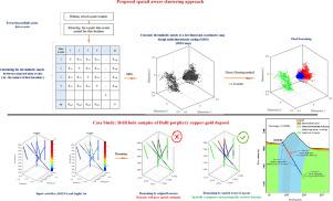
Partitioning of borehole samples into homogenous attributes and continuous spatial domains, here in called ore body domaining, is an important step in mineral resource estimation. Traditional clustering approaches are often resulted in certain domains with poor spatial continuity. Therefore, there is a need to a novel approach to consider the spatial dependency between data locations in clustering analysis. In this research, a certain analysis on multiple-point data events, as a nonparametric higher-order geostatistical approach, is introduced to optimize statistical clustering methods by considering spatial information such as drilling data. Initially, user to extract the n-point data events around each borehole samples defines a fixed spatial n-point template. Then, a dissimilarity matrix is calculated through Euclidean distances between pairs of multiple point data events extracted from the dataset. Next, a multidimensional scaling (MDS) is used to represent the similarity or dissimilarity among samples at a low dimension coordinates matrix. Finally, the matrix obtained from MDS is used as an input of statistical clustering methods to improve its ability in terms of spatial continuity and physical realism. In order to verify the performances of proposed approach, we applied to a 2D synthetic case study and a real case of borehole dataset of the Dalli Cu-Au porphyry. The results were analyzed in terms of statistical contrast among domains and generating the continuous spatial and geological realism domains. Evaluations indicate that the results of the proposed method can be resulted in appropriate continuous spatial domains. In addition, the results of real case study indicated that there was a meaningful compatibility between generated domains from the proposed method and available geological facts.

 求助内容:
求助内容: 应助结果提醒方式:


