Rapid fluvial incision along the Yellow River during headward basin integration
IF 16.1
1区 地球科学
Q1 GEOSCIENCES, MULTIDISCIPLINARY
引用次数: 214
Abstract
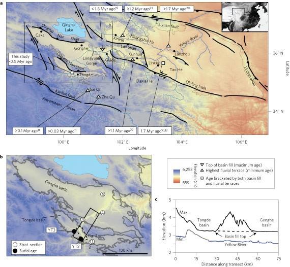
The onset of fluvial erosion in an area of tectonic uplift is thought to reflect the timing of the uplift. Geomorphological data from the Yellow River in Tibet, indicate that the rapid incision of this river channel occurred as a result of climate change, at least six million years after the onset of plateau uplift. The onset of rapid exhumation along the high relief margins of orogenic plateaux is often used as a proxy for the timing of surface uplift1,2,3. However, processes that inhibit incision by rivers, such as spatially variable rock uplift4, orographic changes in rainfall5 and channel damming by glaciers or landslides6,7 may lead to exhumation that significantly lags surface uplift8. Here we reconstruct the timing, rate and pattern of fluvial incision along the Yellow River in northeastern Tibet using stratigraphic, geochronologic and geomorphic data from sedimentary basins along the present-day river course. We find that the onset of fluvial incision occurred substantially later than the onset of mountain building, 14–8 million years (Myr) ago9. Fluvial incision initiated at the plateau margin 1.8 Myr ago10 and progressed upstream11 at a rate of approximately 350 km Myr−1. We conclude that the fluvial incision was a result of a climatically driven expansion of lake systems in the region12,13 that led to lake spillover and consequently the integration of the modern Yellow River.
迎头盆地整合过程中黄河沿岸的快速河道切割
人们认为,构造隆升地区河道侵蚀的开始反映了隆升的时间。西藏黄河的地貌数据表明,这条河道的快速内切是气候变化的结果,至少发生在高原隆升开始的 600 万年之后。沿造山运动高原的高地边缘开始快速隆升通常被用作地表隆升时间的代表1,2,3。然而,抑制河流侵蚀的过程,如空间可变的岩石隆起4、降雨量的地貌变化5、冰川或滑坡对河道的阻挡6,7,可能导致掘起明显滞后于地表隆起8。在此,我们利用沿今河道沉积盆地的地层、地质年代和地貌数据,重建了西藏东北部黄河沿岸河道内切的时间、速度和模式。我们发现,黄河开始侵蚀的时间大大晚于造山运动的开始时间,即距今 1400-800 万年前9。冲积侵蚀开始于 180 万年前的高原边缘10 ,并以大约 350 公里/年的速度向上游发展11。我们的结论是,冲积切裂是该地区湖泊系统受气候影响扩张的结果12,13 ,导致了湖泊溢出,进而形成了现代黄河。
本文章由计算机程序翻译,如有差异,请以英文原文为准。
求助全文
约1分钟内获得全文
求助全文
来源期刊
Nature Geoscience
地学-地球科学综合
CiteScore
26.70
自引率
1.60%
发文量
187
审稿时长
3.3 months
期刊介绍:
Nature Geoscience is a monthly interdisciplinary journal that gathers top-tier research spanning Earth Sciences and related fields.
The journal covers all geoscience disciplines, including fieldwork, modeling, and theoretical studies.
Topics include atmospheric science, biogeochemistry, climate science, geobiology, geochemistry, geoinformatics, remote sensing, geology, geomagnetism, paleomagnetism, geomorphology, geophysics, glaciology, hydrology, limnology, mineralogy, oceanography, paleontology, paleoclimatology, paleoceanography, petrology, planetary science, seismology, space physics, tectonics, and volcanology.
Nature Geoscience upholds its commitment to publishing significant, high-quality Earth Sciences research through fair, rapid, and rigorous peer review, overseen by a team of full-time professional editors.
 求助内容:
求助内容: 应助结果提醒方式:


