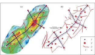
{"title":"Results of Geodynamic Observations at the Zhanazhol Field, Kazakhstan","authors":"Yu. O. Kuzmin, A. I. Nikonov","doi":"10.3103/S0747923922030094","DOIUrl":null,"url":null,"abstract":"<p>Repeated geodetic (ground and satellite) and gravimetric observations were carried out at the geodynamic test site at the Zhanazhol oil field (Kazakhstan) in 2010–2013. The results of leveling observations were analyzed, and local anomalies of Earth’s surface vertical displacements in fault zones were revealed. Comparison of the results of ground-based and satellite geodetic observations showed that the distribution of vertical displacements of the Earth’s surface obtained from GNSS measurements are in sharp contradiction with the releveling data. A paradoxical discrepancy between the ratio of vertical and horizontal displacements of the Earth’s surface throughout the entire field has been established. It is shown that in areas of maximum uplift or subsidence of the surface, intense horizontal displacements are observed, which contradicts the laws of geomechanics for deep objects with volumetric deformation. In these areas, horizontal displacements should have zero or minimum horizontal movement amplitude. The results of repeated leveling and gravimetric observations are compared. A regular relationship has been revealed between local subsidence of the Earth’s surface in fault zones and variations in the gravitational field. A correspondence has been established between the sign of displacements of the Earth’s surface (subsidence, uplift) and the features of development of the field. It is proposed to use geodynamic monitoring as a method for additional monitoring of field development processes.</p>","PeriodicalId":45174,"journal":{"name":"Seismic Instruments","volume":"58 3","pages":"283 - 294"},"PeriodicalIF":0.3000,"publicationDate":"2022-05-23","publicationTypes":"Journal Article","fieldsOfStudy":null,"isOpenAccess":false,"openAccessPdf":"","citationCount":"0","resultStr":null,"platform":"Semanticscholar","paperid":null,"PeriodicalName":"Seismic Instruments","FirstCategoryId":"1085","ListUrlMain":"https://link.springer.com/article/10.3103/S0747923922030094","RegionNum":0,"RegionCategory":null,"ArticlePicture":[],"TitleCN":null,"AbstractTextCN":null,"PMCID":null,"EPubDate":"","PubModel":"","JCR":"Q4","JCRName":"GEOCHEMISTRY & GEOPHYSICS","Score":null,"Total":0}
引用次数: 0
Abstract
Repeated geodetic (ground and satellite) and gravimetric observations were carried out at the geodynamic test site at the Zhanazhol oil field (Kazakhstan) in 2010–2013. The results of leveling observations were analyzed, and local anomalies of Earth’s surface vertical displacements in fault zones were revealed. Comparison of the results of ground-based and satellite geodetic observations showed that the distribution of vertical displacements of the Earth’s surface obtained from GNSS measurements are in sharp contradiction with the releveling data. A paradoxical discrepancy between the ratio of vertical and horizontal displacements of the Earth’s surface throughout the entire field has been established. It is shown that in areas of maximum uplift or subsidence of the surface, intense horizontal displacements are observed, which contradicts the laws of geomechanics for deep objects with volumetric deformation. In these areas, horizontal displacements should have zero or minimum horizontal movement amplitude. The results of repeated leveling and gravimetric observations are compared. A regular relationship has been revealed between local subsidence of the Earth’s surface in fault zones and variations in the gravitational field. A correspondence has been established between the sign of displacements of the Earth’s surface (subsidence, uplift) and the features of development of the field. It is proposed to use geodynamic monitoring as a method for additional monitoring of field development processes.
期刊介绍:
Seismic Instruments is a journal devoted to the description of geophysical instruments used in seismic research. In addition to covering the actual instruments for registering seismic waves, substantial room is devoted to solving instrumental-methodological problems of geophysical monitoring, applying various methods that are used to search for earthquake precursors, to studying earthquake nucleation processes and to monitoring natural and technogenous processes. The description of the construction, working elements, and technical characteristics of the instruments, as well as some results of implementation of the instruments and interpretation of the results are given. Attention is paid to seismic monitoring data and earthquake catalog quality Analysis.
 求助内容:
求助内容: 应助结果提醒方式:


