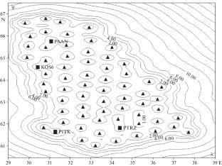
{"title":"Optimal Configuration of the Karelian Seismological Network","authors":"V. Yu. Burmin","doi":"10.3103/S0747923922070039","DOIUrl":null,"url":null,"abstract":"<p>The modern seismological network of Karelia consists of four seismic stations. The number of network stations is small, and they are unevenly distributed over the territory of Karelia. Therefore, this seismological network is not efficient enough, and seismic events (earthquakes and quarry blasts) with different minimum magnitudes and different accuracies are recorded at different points in the territory. In order for events occurring at different points of Karelia to be recorded with the same accuracy and the same minimum magnitude, it is necessary to arrange the system’s seismic stations more evenly throughout the territory; i.e., the observing system must have the optimal configuration. Calculation of the minimum magnitudes of recorded seismic events for the optimal seismological network from 65 new and 4 currently functioning seismic stations shows that with an amplification in recording channels of 50 000, the network will reliably record earthquakes with a magnitude of 1.0 or more throughout Karelia. At the same time, the position of the seismic stations of such a network in Karelia is determined up to a parallel shift and arbitrary rotation of the entire observation system. Errors in determining the epicentral coordinates in latitude and longitude within the network will not exceed 0.5 km. The errors in determining the depths of earthquake sources recorded by the system throughout Karelia do not exceed 1.0 km at the center of the network and can reach 2.0 km only on its periphery.</p>","PeriodicalId":45174,"journal":{"name":"Seismic Instruments","volume":"58 1","pages":"S89 - S98"},"PeriodicalIF":0.3000,"publicationDate":"2023-03-20","publicationTypes":"Journal Article","fieldsOfStudy":null,"isOpenAccess":false,"openAccessPdf":"","citationCount":"0","resultStr":null,"platform":"Semanticscholar","paperid":null,"PeriodicalName":"Seismic Instruments","FirstCategoryId":"1085","ListUrlMain":"https://link.springer.com/article/10.3103/S0747923922070039","RegionNum":0,"RegionCategory":null,"ArticlePicture":[],"TitleCN":null,"AbstractTextCN":null,"PMCID":null,"EPubDate":"","PubModel":"","JCR":"Q4","JCRName":"GEOCHEMISTRY & GEOPHYSICS","Score":null,"Total":0}
引用次数: 0
Abstract
The modern seismological network of Karelia consists of four seismic stations. The number of network stations is small, and they are unevenly distributed over the territory of Karelia. Therefore, this seismological network is not efficient enough, and seismic events (earthquakes and quarry blasts) with different minimum magnitudes and different accuracies are recorded at different points in the territory. In order for events occurring at different points of Karelia to be recorded with the same accuracy and the same minimum magnitude, it is necessary to arrange the system’s seismic stations more evenly throughout the territory; i.e., the observing system must have the optimal configuration. Calculation of the minimum magnitudes of recorded seismic events for the optimal seismological network from 65 new and 4 currently functioning seismic stations shows that with an amplification in recording channels of 50 000, the network will reliably record earthquakes with a magnitude of 1.0 or more throughout Karelia. At the same time, the position of the seismic stations of such a network in Karelia is determined up to a parallel shift and arbitrary rotation of the entire observation system. Errors in determining the epicentral coordinates in latitude and longitude within the network will not exceed 0.5 km. The errors in determining the depths of earthquake sources recorded by the system throughout Karelia do not exceed 1.0 km at the center of the network and can reach 2.0 km only on its periphery.
期刊介绍:
Seismic Instruments is a journal devoted to the description of geophysical instruments used in seismic research. In addition to covering the actual instruments for registering seismic waves, substantial room is devoted to solving instrumental-methodological problems of geophysical monitoring, applying various methods that are used to search for earthquake precursors, to studying earthquake nucleation processes and to monitoring natural and technogenous processes. The description of the construction, working elements, and technical characteristics of the instruments, as well as some results of implementation of the instruments and interpretation of the results are given. Attention is paid to seismic monitoring data and earthquake catalog quality Analysis.
 求助内容:
求助内容: 应助结果提醒方式:


