José Luis Peña-Monné, María Marta Sampietro-Vattuone, Uribe Agudo Paula, Rosario García Giménez, Arsenio Muñoz, David Badia Villas, María Ángeles Magallón Botaya
{"title":"Structure, evolutionary context and chronological data of the Monforte de Moyuela Roman dam (Ebro Basin, NE of Spain)","authors":"José Luis Peña-Monné, María Marta Sampietro-Vattuone, Uribe Agudo Paula, Rosario García Giménez, Arsenio Muñoz, David Badia Villas, María Ángeles Magallón Botaya","doi":"10.1002/gea.21953","DOIUrl":null,"url":null,"abstract":"<p>The Monforte de Moyuela dam, also known as Ermita de la Virgen del Pilar dam, is a Roman reservoir built on a tributary of the Aguasvivas River (Ebro basin, Spain). A multidisciplinary study has been carried out to investigate this kind of Roman water infrastructure. It is the fifth-highest dam (16.8 m) in the Iberian Peninsula and the seventh in the Roman Empire. The initial dam was built ca. 100 B.C.–10 A.D., probably in the period of Augustus, like other nearby Roman dams. It was quickly filled due to the extreme and generalized anthropic degradation in the basin during the Roman period. During the mid-2nd century, the wall was increased in height and its final silting was dated to the early 7th century. The study of the <i>opus caementicium</i> mortars shows constructive differences between the initial and subsequent phases of the wall. These mortars provided charcoal for dating the two phases. In addition, the stratigraphic and edaphological study of the reservoir's sedimentary fill, together with the <sup>14</sup>C ages, allowed us to reconstruct the two main activity cycles and the final siltation of the dam. Subsequently, the dam broke in two phases, which created the two stepped sections located on the current valley bottom. The data obtained allowed the creation of a geomorphological map and an evolutionary model of the valley showing the main differentiated stages, from the initial construction of the dam to its final opening. Although some remains of canals downstream of the dam have been identified, the use of this dam, which remained active for several centuries, still needs to be investigated in greater detail.</p>","PeriodicalId":55117,"journal":{"name":"Geoarchaeology-An International Journal","volume":"38 4","pages":"482-509"},"PeriodicalIF":1.4000,"publicationDate":"2022-12-24","publicationTypes":"Journal Article","fieldsOfStudy":null,"isOpenAccess":false,"openAccessPdf":"https://onlinelibrary.wiley.com/doi/epdf/10.1002/gea.21953","citationCount":"0","resultStr":null,"platform":"Semanticscholar","paperid":null,"PeriodicalName":"Geoarchaeology-An International Journal","FirstCategoryId":"89","ListUrlMain":"https://onlinelibrary.wiley.com/doi/10.1002/gea.21953","RegionNum":3,"RegionCategory":"地球科学","ArticlePicture":[],"TitleCN":null,"AbstractTextCN":null,"PMCID":null,"EPubDate":"","PubModel":"","JCR":"0","JCRName":"ARCHAEOLOGY","Score":null,"Total":0}
引用次数: 0
Abstract
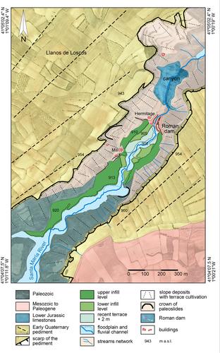
The Monforte de Moyuela dam, also known as Ermita de la Virgen del Pilar dam, is a Roman reservoir built on a tributary of the Aguasvivas River (Ebro basin, Spain). A multidisciplinary study has been carried out to investigate this kind of Roman water infrastructure. It is the fifth-highest dam (16.8 m) in the Iberian Peninsula and the seventh in the Roman Empire. The initial dam was built ca. 100 B.C.–10 A.D., probably in the period of Augustus, like other nearby Roman dams. It was quickly filled due to the extreme and generalized anthropic degradation in the basin during the Roman period. During the mid-2nd century, the wall was increased in height and its final silting was dated to the early 7th century. The study of the opus caementicium mortars shows constructive differences between the initial and subsequent phases of the wall. These mortars provided charcoal for dating the two phases. In addition, the stratigraphic and edaphological study of the reservoir's sedimentary fill, together with the 14C ages, allowed us to reconstruct the two main activity cycles and the final siltation of the dam. Subsequently, the dam broke in two phases, which created the two stepped sections located on the current valley bottom. The data obtained allowed the creation of a geomorphological map and an evolutionary model of the valley showing the main differentiated stages, from the initial construction of the dam to its final opening. Although some remains of canals downstream of the dam have been identified, the use of this dam, which remained active for several centuries, still needs to be investigated in greater detail.
Monforte de Moyuela大坝,也被称为Ermita de la Virgen del Pilar大坝,是一座建于Aguasvivas河(西班牙Ebro盆地)支流上的罗马水库。一项多学科研究已经开展,以调查这种罗马水基础设施。它是伊比利亚半岛第五高的水坝(16.8米),也是罗马帝国第七高的水坝。最初的大坝大约建于公元前100年至公元10年,可能是在奥古斯都时期,和附近的其他罗马大坝一样。由于罗马时期盆地的极端和普遍的人为退化,它很快被填满。在2世纪中期,城墙的高度有所增加,最后的淤积可以追溯到7世纪初。对水泥砂浆的研究表明,墙的初始阶段和后续阶段之间存在建设性差异。这些灰泥提供了测定这两个阶段年代的木炭。此外,对水库沉积填充物的地层学和土壤学研究,以及14C年龄,使我们能够重建两个主要的活动周期和大坝的最终淤积。随后,大坝分两个阶段决堤,形成了位于现在谷底的两个阶梯式部分。获得的数据可以创建地貌图和山谷的演化模型,显示从大坝最初建设到最终开放的主要不同阶段。虽然已经确定了大坝下游的一些运河遗迹,但这个几个世纪以来一直活跃的大坝的使用情况仍需要进行更详细的调查。
期刊介绍:
Geoarchaeology is an interdisciplinary journal published six times per year (in January, March, May, July, September and November). It presents the results of original research at the methodological and theoretical interface between archaeology and the geosciences and includes within its scope: interdisciplinary work focusing on understanding archaeological sites, their environmental context, and particularly site formation processes and how the analysis of sedimentary records can enhance our understanding of human activity in Quaternary environments. Manuscripts should examine the interrelationship between archaeology and the various disciplines within Quaternary science and the Earth Sciences more generally, including, for example: geology, geography, geomorphology, pedology, climatology, oceanography, geochemistry, geochronology, and geophysics. We also welcome papers that deal with the biological record of past human activity through the analysis of faunal and botanical remains and palaeoecological reconstructions that shed light on past human-environment interactions. The journal also welcomes manuscripts concerning the examination and geological context of human fossil remains as well as papers that employ analytical techniques to advance understanding of the composition and origin or material culture such as, for example, ceramics, metals, lithics, building stones, plasters, and cements. Such composition and provenance studies should be strongly grounded in their geological context through, for example, the systematic analysis of potential source materials.
 求助内容:
求助内容: 应助结果提醒方式:


