Updated seismic hazard curves, maps, and spectra for the northern Dominican Republic using a probabilistic seismic hazard analysis

IF 1.6 4区 地球科学 Q3 GEOCHEMISTRY & GEOPHYSICS
Kalil Erazo
{"title":"Updated seismic hazard curves, maps, and spectra for the northern Dominican Republic using a probabilistic seismic hazard analysis","authors":"Kalil Erazo","doi":"10.1007/s10950-023-10150-y","DOIUrl":null,"url":null,"abstract":"<div><p>This article presents updated seismic hazard curves, spectra, and maps of ground motion intensity measures for the northern region of the Dominican Republic (DR) obtained using a probabilistic seismic hazard analysis (PSHA). The analysis performed uses as input data an earthquake recurrence model based on fault slip rates derived from GPS measurements published in the aftermath of the 2010 Haiti earthquake. The seismicity rate data are used to calibrate a composite characteristic earthquake model, which is combined with a Poisson process to provide a temporal characterization of earthquake occurrence. The seismic hazard curves and maps presented include parameters such as (horizontal) peak ground acceleration and pseudo-spectral response accelerations at 0.2s and 1.0s periods for 5% damping at firm rock sites. The results show that the ground motion parameters with a 2% probability of exceedance (PE) in 50 years determined in this study are up to 46% larger than the corresponding parameters specified in the current DR building code seismic hazard maps for the northern DR. Moreover, the design response spectra for a site in the city of Santiago specified in the code is significantly lower than the 2% PE in 50 years uniform hazard spectra determined in this study for vibration periods smaller than 0.5s, a range that includes the majority of the structures that define the built environment of the DR.</p></div>","PeriodicalId":16994,"journal":{"name":"Journal of Seismology","volume":null,"pages":null},"PeriodicalIF":1.6000,"publicationDate":"2023-05-18","publicationTypes":"Journal Article","fieldsOfStudy":null,"isOpenAccess":false,"openAccessPdf":"","citationCount":"0","resultStr":null,"platform":"Semanticscholar","paperid":null,"PeriodicalName":"Journal of Seismology","FirstCategoryId":"89","ListUrlMain":"https://link.springer.com/article/10.1007/s10950-023-10150-y","RegionNum":4,"RegionCategory":"地球科学","ArticlePicture":[],"TitleCN":null,"AbstractTextCN":null,"PMCID":null,"EPubDate":"","PubModel":"","JCR":"Q3","JCRName":"GEOCHEMISTRY & GEOPHYSICS","Score":null,"Total":0}
引用次数: 0

Abstract

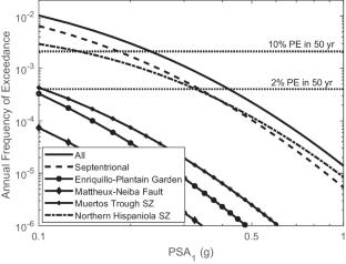
This article presents updated seismic hazard curves, spectra, and maps of ground motion intensity measures for the northern region of the Dominican Republic (DR) obtained using a probabilistic seismic hazard analysis (PSHA). The analysis performed uses as input data an earthquake recurrence model based on fault slip rates derived from GPS measurements published in the aftermath of the 2010 Haiti earthquake. The seismicity rate data are used to calibrate a composite characteristic earthquake model, which is combined with a Poisson process to provide a temporal characterization of earthquake occurrence. The seismic hazard curves and maps presented include parameters such as (horizontal) peak ground acceleration and pseudo-spectral response accelerations at 0.2s and 1.0s periods for 5% damping at firm rock sites. The results show that the ground motion parameters with a 2% probability of exceedance (PE) in 50 years determined in this study are up to 46% larger than the corresponding parameters specified in the current DR building code seismic hazard maps for the northern DR. Moreover, the design response spectra for a site in the city of Santiago specified in the code is significantly lower than the 2% PE in 50 years uniform hazard spectra determined in this study for vibration periods smaller than 0.5s, a range that includes the majority of the structures that define the built environment of the DR.
Abstract Image

使用概率地震灾害分析更新了多米尼加共和国北部的地震灾害曲线、地图和光谱
本文介绍了多米尼加共和国(DR)北部地区使用概率地震危害分析(PSHA)获得的最新地震危险曲线、光谱和地震动强度测量图。该分析使用基于断层滑动率的地震重现模型作为输入数据,该模型来源于2010年海地地震后发布的GPS测量数据。地震活动性数据用于校准一个复合特征地震模型,该模型与泊松过程相结合,以提供地震发生的时间特征。给出的地震危险曲线和地图包括(水平)峰值地面加速度和伪谱响应加速度等参数,在坚固的岩石场地,在5%的阻尼下,0.2s和1.0s周期。结果表明,本研究确定的50年超过概率为2%的地震动参数比现行DR建筑规范中DR北部地震危险度图中规定的相应参数大46%。规范中规定的圣地亚迭市一个场地的设计响应谱明显低于本研究确定的振动周期小于0.5s的50年均匀危险谱的2% PE,该范围包括定义DR建筑环境的大多数结构。
本文章由计算机程序翻译,如有差异,请以英文原文为准。
求助全文
约1分钟内获得全文 求助全文
来源期刊
Journal of Seismology
Journal of Seismology 地学-地球化学与地球物理
CiteScore
3.30
自引率
6.20%
发文量
67
审稿时长
3 months
期刊介绍: Journal of Seismology is an international journal specialising in all observational and theoretical aspects related to earthquake occurrence. Research topics may cover: seismotectonics, seismicity, historical seismicity, seismic source physics, strong ground motion studies, seismic hazard or risk, engineering seismology, physics of fault systems, triggered and induced seismicity, mining seismology, volcano seismology, earthquake prediction, structural investigations ranging from local to regional and global studies with a particular focus on passive experiments.
×
引用
GB/T 7714-2015
复制
MLA
复制
APA
复制
导出至
BibTeX EndNote RefMan NoteFirst NoteExpress
×
提示
您的信息不完整,为了账户安全,请先补充。
现在去补充
×
提示
您因"违规操作"
具体请查看互助需知
我知道了
×
提示
确定
请完成安全验证×
copy
已复制链接
快去分享给好友吧!
我知道了
右上角分享
点击右上角分享
0
联系我们:info@booksci.cn Book学术提供免费学术资源搜索服务,方便国内外学者检索中英文文献。致力于提供最便捷和优质的服务体验。 Copyright © 2023 布克学术 All rights reserved.
京ICP备2023020795号-1
ghs 京公网安备 11010802042870号
Book学术文献互助
Book学术文献互助群
群 号:481959085
Book学术官方微信