Sonam , Vikrant Jain , Kirstie Fryirs , Gary Brierley
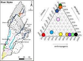
{"title":"Geomorphic characterization of a seasonal river network in semi-arid western India using the River Styles Framework","authors":"Sonam , Vikrant Jain , Kirstie Fryirs , Gary Brierley","doi":"10.1016/j.jaesx.2021.100077","DOIUrl":null,"url":null,"abstract":"<div><p>The imprint of geologic, climatic and anthropogenic memory as controls on geomorphic river diversity is assessed for twelve River Styles in the Sabarmati Catchment. Geologic controls are the primary determinant of river character and behavior in the hinterland and pediment landscape units, where headwater streams transition to partly confined valleys and gorges with distinct structural lineations in a rectangular drainage network. Climate memory imprints entrenched rivers that make up alluvial fan and alluvial plain landscape units of the mid-lower catchment, shaped by phases of sediment aggradation and subsequent incision in response to enhanced monsoonal rains around 10 ka. Terraces constrain channels within confined and partly confined valleys with occasional and discontinuous floodplains respectively. Laterally unconfined channels are only found in the lower parts of the catchment, immediately upstream of the estuary/delta. Limited space for adjustment, impacts of flow regulation and ephemeral conditions restrict the range of contemporary river morphodynamics, but ridges and swales and abandoned channels on floodplains indicate more dynamic conditions in the past. Impacts of anthropogenic memory are most pronounced in the stopbank-controlled, barrage- and dam-impacted reaches, especially in the cities of Gandhinagar and Ahmedabad. An explanation of controls upon geomorphic river diversity, including an assessment of the role of stream power, presents a coherent platform to develop geomorphologically-informed approaches to river management.</p></div>","PeriodicalId":37149,"journal":{"name":"Journal of Asian Earth Sciences: X","volume":"7 ","pages":"Article 100077"},"PeriodicalIF":1.7000,"publicationDate":"2022-06-01","publicationTypes":"Journal Article","fieldsOfStudy":null,"isOpenAccess":false,"openAccessPdf":"https://www.sciencedirect.com/science/article/pii/S2590056021000347/pdfft?md5=906222133b98497122c11e1a452c0fe2&pid=1-s2.0-S2590056021000347-main.pdf","citationCount":"5","resultStr":null,"platform":"Semanticscholar","paperid":null,"PeriodicalName":"Journal of Asian Earth Sciences: X","FirstCategoryId":"1085","ListUrlMain":"https://www.sciencedirect.com/science/article/pii/S2590056021000347","RegionNum":0,"RegionCategory":null,"ArticlePicture":[],"TitleCN":null,"AbstractTextCN":null,"PMCID":null,"EPubDate":"","PubModel":"","JCR":"Q3","JCRName":"GEOSCIENCES, MULTIDISCIPLINARY","Score":null,"Total":0}
引用次数: 5
Abstract
The imprint of geologic, climatic and anthropogenic memory as controls on geomorphic river diversity is assessed for twelve River Styles in the Sabarmati Catchment. Geologic controls are the primary determinant of river character and behavior in the hinterland and pediment landscape units, where headwater streams transition to partly confined valleys and gorges with distinct structural lineations in a rectangular drainage network. Climate memory imprints entrenched rivers that make up alluvial fan and alluvial plain landscape units of the mid-lower catchment, shaped by phases of sediment aggradation and subsequent incision in response to enhanced monsoonal rains around 10 ka. Terraces constrain channels within confined and partly confined valleys with occasional and discontinuous floodplains respectively. Laterally unconfined channels are only found in the lower parts of the catchment, immediately upstream of the estuary/delta. Limited space for adjustment, impacts of flow regulation and ephemeral conditions restrict the range of contemporary river morphodynamics, but ridges and swales and abandoned channels on floodplains indicate more dynamic conditions in the past. Impacts of anthropogenic memory are most pronounced in the stopbank-controlled, barrage- and dam-impacted reaches, especially in the cities of Gandhinagar and Ahmedabad. An explanation of controls upon geomorphic river diversity, including an assessment of the role of stream power, presents a coherent platform to develop geomorphologically-informed approaches to river management.
 求助内容:
求助内容: 应助结果提醒方式:


