Evaluation of data accuracies within a comprehensive geospatial-health data surveillance platform: SOMAARTH Demographic Development and Environmental Surveillance Site, Palwal, Haryana, India.
IF 1.1 Q4 PUBLIC, ENVIRONMENTAL & OCCUPATIONAL HEALTH
Natasha J Howard, Shikha Dixit, Hasan Raja Naqvi, Atiqur Rahman, Catherine Paquet, Mark Daniel, Narendra K Arora
{"title":"Evaluation of data accuracies within a comprehensive geospatial-health data surveillance platform: SOMAARTH Demographic Development and Environmental Surveillance Site, Palwal, Haryana, India.","authors":"Natasha J Howard, Shikha Dixit, Hasan Raja Naqvi, Atiqur Rahman, Catherine Paquet, Mark Daniel, Narendra K Arora","doi":"10.1017/gheg.2018.17","DOIUrl":null,"url":null,"abstract":"<p><p>Evidence exists of an increasing prevalence of chronic conditions within developed and developing nations, notably for priority population groups. The need for the collection of geospatial data to monitor the health impact of rapid social-environmental and economic changes occurring in these countries is being increasingly recognized. Rigorous accuracy assessment of such geospatial data is required to enable error estimation, and ultimately, data utility for exploring population health. This research outlines findings from a field-based evaluation exercise of the SOMAARTH DDESS geospatial-health platform. Participatory-based mixed methods have been employed within Palwal-India to capture villager perspectives on built infrastructure across 51 villages. This study, conducted in 2013, included an assessment of data element position and attribute accuracy undertaken in six villages, documenting mapping errors and land parcel changes. Descriptive analyses of 5.1% (<i>n</i> = 455) of land parcels highlighted some discrepancies in position (6.4%) and attribute (4.2%) accuracy, and land parcel changes (17.4%). Furthermore, the evaluation led to a refinement of the existing geospatial health platform incorporating ground-truthed reflections from the participatory field exercise. The evaluation of geospatial data accuracies contributes to understandings on global public health surveillance systems, outlining the need to systematically consider assessment of environmental features in relation to lifestyle-related diseases.</p>","PeriodicalId":44052,"journal":{"name":"Global Health Epidemiology and Genomics","volume":"3 ","pages":"e19"},"PeriodicalIF":1.1000,"publicationDate":"2018-12-27","publicationTypes":"Journal Article","fieldsOfStudy":null,"isOpenAccess":false,"openAccessPdf":"https://sci-hub-pdf.com/10.1017/gheg.2018.17","citationCount":"1","resultStr":null,"platform":"Semanticscholar","paperid":null,"PeriodicalName":"Global Health Epidemiology and Genomics","FirstCategoryId":"1085","ListUrlMain":"https://doi.org/10.1017/gheg.2018.17","RegionNum":0,"RegionCategory":null,"ArticlePicture":[],"TitleCN":null,"AbstractTextCN":null,"PMCID":null,"EPubDate":"2018/1/1 0:00:00","PubModel":"eCollection","JCR":"Q4","JCRName":"PUBLIC, ENVIRONMENTAL & OCCUPATIONAL HEALTH","Score":null,"Total":0}
引用次数: 1
Abstract
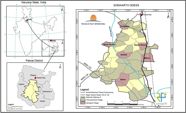
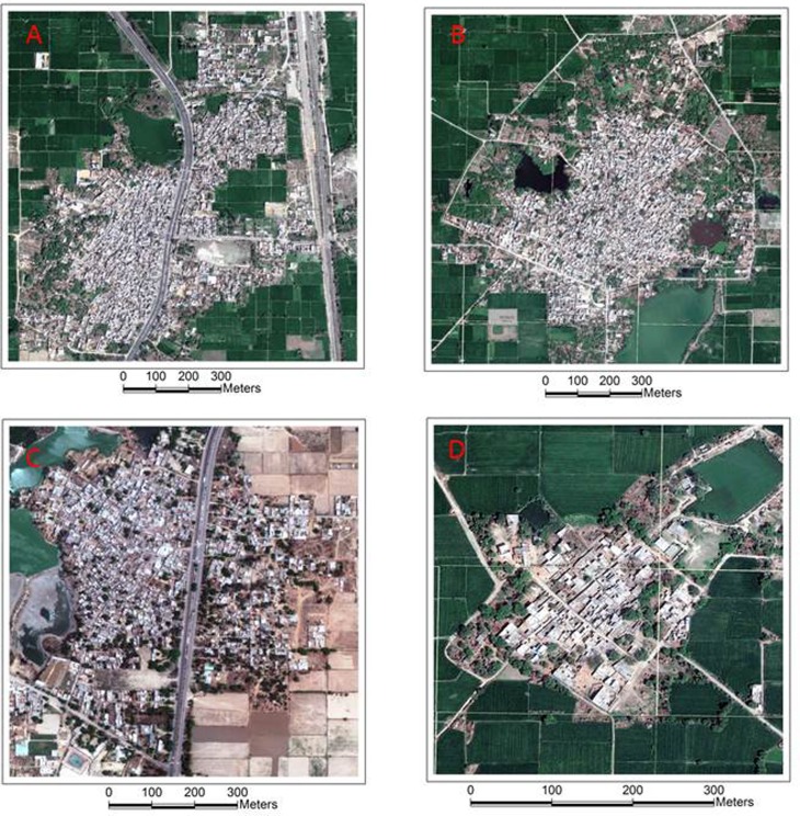
Evidence exists of an increasing prevalence of chronic conditions within developed and developing nations, notably for priority population groups. The need for the collection of geospatial data to monitor the health impact of rapid social-environmental and economic changes occurring in these countries is being increasingly recognized. Rigorous accuracy assessment of such geospatial data is required to enable error estimation, and ultimately, data utility for exploring population health. This research outlines findings from a field-based evaluation exercise of the SOMAARTH DDESS geospatial-health platform. Participatory-based mixed methods have been employed within Palwal-India to capture villager perspectives on built infrastructure across 51 villages. This study, conducted in 2013, included an assessment of data element position and attribute accuracy undertaken in six villages, documenting mapping errors and land parcel changes. Descriptive analyses of 5.1% (n = 455) of land parcels highlighted some discrepancies in position (6.4%) and attribute (4.2%) accuracy, and land parcel changes (17.4%). Furthermore, the evaluation led to a refinement of the existing geospatial health platform incorporating ground-truthed reflections from the participatory field exercise. The evaluation of geospatial data accuracies contributes to understandings on global public health surveillance systems, outlining the need to systematically consider assessment of environmental features in relation to lifestyle-related diseases.


 求助内容:
求助内容: 应助结果提醒方式:


