Luke Nyakarahuka, Samuel Ayebare, Gladys Mosomtai, Clovice Kankya, Julius Lutwama, Frank Norbert Mwiine, Eystein Skjerve
{"title":"Ecological Niche Modeling for Filoviruses: A Risk Map for Ebola and Marburg Virus Disease Outbreaks in Uganda.","authors":"Luke Nyakarahuka, Samuel Ayebare, Gladys Mosomtai, Clovice Kankya, Julius Lutwama, Frank Norbert Mwiine, Eystein Skjerve","doi":"10.1371/currents.outbreaks.07992a87522e1f229c7cb023270a2af1","DOIUrl":null,"url":null,"abstract":"<p><strong>Introduction: </strong>Uganda has reported eight outbreaks caused by filoviruses between 2000 to 2016, more than any other country in the world. We used species distribution modeling to predict where filovirus outbreaks are likely to occur in Uganda to help in epidemic preparedness and surveillance.</p><p><strong>Methods: </strong>The MaxEnt software, a machine learning modeling approach that uses presence-only data was used to establish filovirus - environmental relationships. Presence-only data for filovirus outbreaks were collected from the field and online sources. Environmental covariates from Africlim that have been downscaled to a nominal resolution of 1km x 1km were used. The final model gave the relative probability of the presence of filoviruses in the study area obtained from an average of 100 bootstrap runs. Model evaluation was carried out using Receiver Operating Characteristic (ROC) plots. Maps were created using ArcGIS 10.3 mapping software.</p><p><strong>Results: </strong>We showed that bats as potential reservoirs of filoviruses are distributed all over Uganda. Potential outbreak areas for Ebola and Marburg virus disease were predicted in West, Southwest and Central parts of Uganda, which corresponds to bat distribution and previous filovirus outbreaks areas. Additionally, the models predicted the Eastern Uganda region and other areas that have not reported outbreaks before to be potential outbreak hotspots. Rainfall variables were the most important in influencing model prediction compared to temperature variables.</p><p><strong>Conclusions: </strong>Despite the limitations in the prediction model due to lack of adequate sample records for outbreaks, especially for the Marburg cases, the models provided risk maps to the Uganda surveillance system on filovirus outbreaks. The risk maps will aid in identifying areas to focus the filovirus surveillance for early detection and responses hence curtailing a pandemic. The results from this study also confirm previous findings that suggest that filoviruses are mainly limited by the amount of rainfall received in an area.</p>","PeriodicalId":74464,"journal":{"name":"PLoS currents","volume":" ","pages":""},"PeriodicalIF":0.0000,"publicationDate":"2017-09-05","publicationTypes":"Journal Article","fieldsOfStudy":null,"isOpenAccess":false,"openAccessPdf":"https://www.ncbi.nlm.nih.gov/pmc/articles/PMC5614672/pdf/","citationCount":"32","resultStr":null,"platform":"Semanticscholar","paperid":null,"PeriodicalName":"PLoS currents","FirstCategoryId":"1085","ListUrlMain":"https://doi.org/10.1371/currents.outbreaks.07992a87522e1f229c7cb023270a2af1","RegionNum":0,"RegionCategory":null,"ArticlePicture":[],"TitleCN":null,"AbstractTextCN":null,"PMCID":null,"EPubDate":"","PubModel":"","JCR":"","JCRName":"","Score":null,"Total":0}
引用次数: 32
Abstract
Introduction: Uganda has reported eight outbreaks caused by filoviruses between 2000 to 2016, more than any other country in the world. We used species distribution modeling to predict where filovirus outbreaks are likely to occur in Uganda to help in epidemic preparedness and surveillance.
Methods: The MaxEnt software, a machine learning modeling approach that uses presence-only data was used to establish filovirus - environmental relationships. Presence-only data for filovirus outbreaks were collected from the field and online sources. Environmental covariates from Africlim that have been downscaled to a nominal resolution of 1km x 1km were used. The final model gave the relative probability of the presence of filoviruses in the study area obtained from an average of 100 bootstrap runs. Model evaluation was carried out using Receiver Operating Characteristic (ROC) plots. Maps were created using ArcGIS 10.3 mapping software.
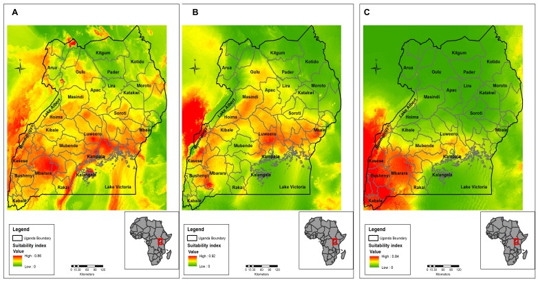
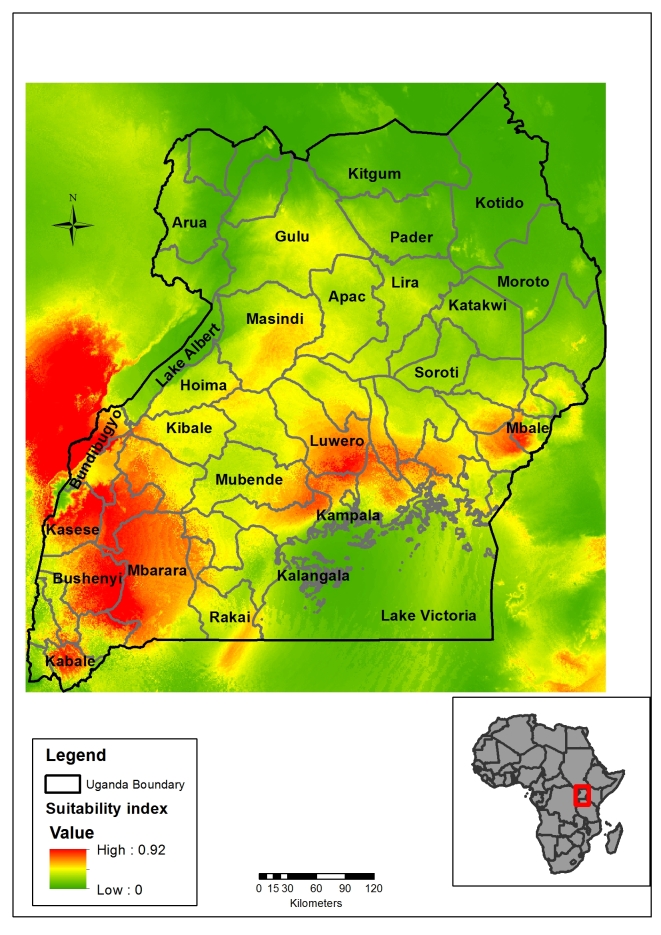
Results: We showed that bats as potential reservoirs of filoviruses are distributed all over Uganda. Potential outbreak areas for Ebola and Marburg virus disease were predicted in West, Southwest and Central parts of Uganda, which corresponds to bat distribution and previous filovirus outbreaks areas. Additionally, the models predicted the Eastern Uganda region and other areas that have not reported outbreaks before to be potential outbreak hotspots. Rainfall variables were the most important in influencing model prediction compared to temperature variables.
Conclusions: Despite the limitations in the prediction model due to lack of adequate sample records for outbreaks, especially for the Marburg cases, the models provided risk maps to the Uganda surveillance system on filovirus outbreaks. The risk maps will aid in identifying areas to focus the filovirus surveillance for early detection and responses hence curtailing a pandemic. The results from this study also confirm previous findings that suggest that filoviruses are mainly limited by the amount of rainfall received in an area.
导言:乌干达在2000年至2016年期间报告了8次由丝状病毒引起的疫情,比世界上任何其他国家都多。我们使用物种分布模型来预测乌干达可能发生线状病毒爆发的地方,以帮助做好流行病的准备和监测。方法:MaxEnt软件是一种机器学习建模方法,使用仅存在的数据来建立线状病毒与环境的关系。从现场和在线来源收集线状病毒暴发的仅存在数据。我们使用了来自非洲的环境协变量,这些协变量已经缩小到名义分辨率为1km x 1km。最后的模型给出了研究区域中丝状病毒存在的相对概率,这是通过平均100次启动运行得到的。采用受试者工作特征(ROC)图对模型进行评价。使用ArcGIS 10.3制图软件制作地图。结果:我们发现蝙蝠是线状病毒的潜在宿主,分布在乌干达各地。预计埃博拉和马尔堡病毒病的潜在暴发地区在乌干达西部、西南部和中部地区,这与蝙蝠分布和以前的线状病毒暴发地区相对应。此外,这些模型预测乌干达东部地区和以前没有报告疫情的其他地区是潜在的疫情热点。与温度变量相比,降雨变量对模式预测的影响最大。结论:尽管由于缺乏足够的疫情,特别是马尔堡病例的样本记录,该预测模型存在局限性,但该模型为乌干达线状病毒疫情监测系统提供了风险图。风险图将有助于确定重点监测丝状病毒的领域,以便及早发现和作出反应,从而减少大流行。这项研究的结果也证实了先前的发现,即线状病毒主要受到一个地区降雨量的限制。

 求助内容:
求助内容: 应助结果提醒方式:


