Identification and apportionment of shallow groundwater nitrate pollution in Weining Plain, northwest China, using hydrochemical indices, nitrate stable isotopes, and the new Bayesian stable isotope mixing model (MixSIAR)
Song He , Peiyue Li , Fengmei Su , Dan Wang , Xiaofei Ren
{"title":"Identification and apportionment of shallow groundwater nitrate pollution in Weining Plain, northwest China, using hydrochemical indices, nitrate stable isotopes, and the new Bayesian stable isotope mixing model (MixSIAR)","authors":"Song He , Peiyue Li , Fengmei Su , Dan Wang , Xiaofei Ren","doi":"10.1016/j.envpol.2022.118852","DOIUrl":null,"url":null,"abstract":"<div><p>Groundwater nitrate (NO<sub>3</sub><sup>−</sup>) pollution is a worldwide environmental problem. Therefore, identification and partitioning of its potential sources are of great importance for effective control of groundwater quality. The current study was carried out to identify the potential sources of groundwater NO<sub>3</sub><sup>−</sup> pollution and determine their apportionment in different land use/land cover (LULC) types in a traditional agricultural area, Weining Plain, in Northwest China. Multiple hydrochemical indices, as well as dual NO<sub>3</sub><sup>−</sup> isotopes (δ<sup>15</sup>N–NO<sub>3</sub> and δ<sup>18</sup>O–NO<sub>3</sub><span><span>), were used to investigate the groundwater quality and its influencing factors. LULC patterns of the study area were first determined by interpreting remote sensing image data collected from the Sentinel-2 satellite, then the Bayesian </span>stable isotope mixing model (MixSIAR) was used to estimate proportional contributions of the potential sources to groundwater NO</span><sub>3</sub><sup>−</sup><span> concentrations. Groundwater quality in the study area was influenced by both natural and anthropogenic factors, with anthropological impact being more important. The results of LULC revealed that the irrigated land is the dominant LULC type in the plain, covering an area of 576.6 km</span><sup>2</sup> (57.18% of the total surface study area of the plain). On the other hand, the results of the NO<sub>3</sub><sup>−</sup><span> isotopes suggested that manure and sewage (M&S), as well as soil nitrogen (SN), were the major contributors to groundwater NO</span><sub>3</sub><sup>−</sup>. Moreover, the results obtained from the MixSIAR model showed that the mean proportional contributions of M&S to groundwater NO<sub>3</sub><sup>−</sup><span> were 55.5, 43.4, 21.4, and 78.7% in the forest, irrigated, paddy, and urban lands, respectively. While SN showed mean proportional contributions of 29.9, 43.4, 61.5, and 12.7% in the forest, irrigated, paddy, and urban lands, respectively. The current study provides valuable information for local authorities to support sustainable groundwater management in the study region.</span></p></div>","PeriodicalId":311,"journal":{"name":"Environmental Pollution","volume":"298 ","pages":"Article 118852"},"PeriodicalIF":7.6000,"publicationDate":"2022-04-01","publicationTypes":"Journal Article","fieldsOfStudy":null,"isOpenAccess":false,"openAccessPdf":"","citationCount":"76","resultStr":null,"platform":"Semanticscholar","paperid":null,"PeriodicalName":"Environmental Pollution","FirstCategoryId":"93","ListUrlMain":"https://www.sciencedirect.com/science/article/pii/S0269749122000665","RegionNum":2,"RegionCategory":"环境科学与生态学","ArticlePicture":[],"TitleCN":null,"AbstractTextCN":null,"PMCID":null,"EPubDate":"","PubModel":"","JCR":"Q1","JCRName":"ENVIRONMENTAL SCIENCES","Score":null,"Total":0}
引用次数: 76
Abstract
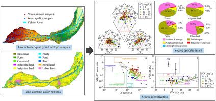
Groundwater nitrate (NO3−) pollution is a worldwide environmental problem. Therefore, identification and partitioning of its potential sources are of great importance for effective control of groundwater quality. The current study was carried out to identify the potential sources of groundwater NO3− pollution and determine their apportionment in different land use/land cover (LULC) types in a traditional agricultural area, Weining Plain, in Northwest China. Multiple hydrochemical indices, as well as dual NO3− isotopes (δ15N–NO3 and δ18O–NO3), were used to investigate the groundwater quality and its influencing factors. LULC patterns of the study area were first determined by interpreting remote sensing image data collected from the Sentinel-2 satellite, then the Bayesian stable isotope mixing model (MixSIAR) was used to estimate proportional contributions of the potential sources to groundwater NO3− concentrations. Groundwater quality in the study area was influenced by both natural and anthropogenic factors, with anthropological impact being more important. The results of LULC revealed that the irrigated land is the dominant LULC type in the plain, covering an area of 576.6 km2 (57.18% of the total surface study area of the plain). On the other hand, the results of the NO3− isotopes suggested that manure and sewage (M&S), as well as soil nitrogen (SN), were the major contributors to groundwater NO3−. Moreover, the results obtained from the MixSIAR model showed that the mean proportional contributions of M&S to groundwater NO3− were 55.5, 43.4, 21.4, and 78.7% in the forest, irrigated, paddy, and urban lands, respectively. While SN showed mean proportional contributions of 29.9, 43.4, 61.5, and 12.7% in the forest, irrigated, paddy, and urban lands, respectively. The current study provides valuable information for local authorities to support sustainable groundwater management in the study region.
期刊介绍:
Environmental Pollution is an international peer-reviewed journal that publishes high-quality research papers and review articles covering all aspects of environmental pollution and its impacts on ecosystems and human health.
Subject areas include, but are not limited to:
• Sources and occurrences of pollutants that are clearly defined and measured in environmental compartments, food and food-related items, and human bodies;
• Interlinks between contaminant exposure and biological, ecological, and human health effects, including those of climate change;
• Contaminants of emerging concerns (including but not limited to antibiotic resistant microorganisms or genes, microplastics/nanoplastics, electronic wastes, light, and noise) and/or their biological, ecological, or human health effects;
• Laboratory and field studies on the remediation/mitigation of environmental pollution via new techniques and with clear links to biological, ecological, or human health effects;
• Modeling of pollution processes, patterns, or trends that is of clear environmental and/or human health interest;
• New techniques that measure and examine environmental occurrences, transport, behavior, and effects of pollutants within the environment or the laboratory, provided that they can be clearly used to address problems within regional or global environmental compartments.
 求助内容:
求助内容: 应助结果提醒方式:


