Characterizing soil salinity at multiple depth using electromagnetic induction and remote sensing data with random forests: A case study in Tarim River Basin of southern Xinjiang, China
Fei Wang , Shengtian Yang , Yang Wei , Qian Shi , Jianli Ding
{"title":"Characterizing soil salinity at multiple depth using electromagnetic induction and remote sensing data with random forests: A case study in Tarim River Basin of southern Xinjiang, China","authors":"Fei Wang , Shengtian Yang , Yang Wei , Qian Shi , Jianli Ding","doi":"10.1016/j.scitotenv.2020.142030","DOIUrl":null,"url":null,"abstract":"<div><p>Tarim River Basin is experiencing heavy soil degeneration in a long term because of the extreme natural conditions, added with improper human activities such as reclamation and rejected field repeatedly, which hindered the soil health. One of the mainly form is soil salinization. Spatial distribution and variation of soil salinity is essential both for agricultural resource management and local economic development. However, knowledge of the spatial distribution of soil salinization in this region has not been updated since 1980s while land use and climate have undergone major changed. Electromagnetic induction (EMI) has been successfully used to directly measurement the spatial distribution of targeting soil property at field- scale, and apparent electrical conductivity (ECa, mS m<sup>−1</sup>) has become a surrogate of soil salinity (EC, dS m<sup>−1</sup>) studied by many researchers at local scale. However, the effectiveness of this equipment has not been verified in the typical soil salinization areas in southern Xinjiang, especially on a large scale. This study was aimed to test the performance of ECa jointed with Random Forest (RF) for soil salinity regional–scale mapping at a typical arid area, taking Tarim River Basin as an example. The result showed that ECa together with environmental derivative variables and with RF were suited for regional–scale soil salinity mapping. Predicted accuracy of EC was higher at surface (0–20 cm, R<sup>2</sup> = 0.65, RMSE = 5.59) and deeper soil depth (60–80 cm, R<sup>2</sup> = 0.63, RMSE = 2.00, and 80–100 cm, R<sup>2</sup> = 0.61, RMSE = 1.73), lower at transitional zone (20–40 cm, R<sup>2</sup> = 0.55, RMSE = 2.66, and 40–60 cm, R<sup>2</sup> = 0.51, RMSE = 2.49). When ECa is involved in modeling, the prediction accuracy of multiple depths of EC is improved by 13.33%–61.54%, of which the most obvious depths are 60–80 cm and 0–20 cm. The results of variable importance show that SoilGrids were also favored the power EC model. Hence, we strongly recommended to joint EMI reads with remote sensing imagery for soil salinity monitoring at large scale in southern Xinjiang. These EC and ECa map can provide a data source for environmental modeling, a benchmark against which to evaluate and monitor water and salt dynamics, and a guide for the design of future soil surveys.</p></div>","PeriodicalId":422,"journal":{"name":"Science of the Total Environment","volume":"754 ","pages":"Article 142030"},"PeriodicalIF":8.2000,"publicationDate":"2021-02-01","publicationTypes":"Journal Article","fieldsOfStudy":null,"isOpenAccess":false,"openAccessPdf":"https://sci-hub-pdf.com/10.1016/j.scitotenv.2020.142030","citationCount":"50","resultStr":null,"platform":"Semanticscholar","paperid":null,"PeriodicalName":"Science of the Total Environment","FirstCategoryId":"93","ListUrlMain":"https://www.sciencedirect.com/science/article/pii/S0048969720355595","RegionNum":1,"RegionCategory":"环境科学与生态学","ArticlePicture":[],"TitleCN":null,"AbstractTextCN":null,"PMCID":null,"EPubDate":"","PubModel":"","JCR":"Q1","JCRName":"ENVIRONMENTAL SCIENCES","Score":null,"Total":0}
引用次数: 50
Abstract
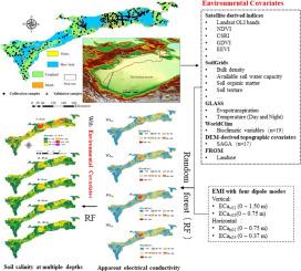
Tarim River Basin is experiencing heavy soil degeneration in a long term because of the extreme natural conditions, added with improper human activities such as reclamation and rejected field repeatedly, which hindered the soil health. One of the mainly form is soil salinization. Spatial distribution and variation of soil salinity is essential both for agricultural resource management and local economic development. However, knowledge of the spatial distribution of soil salinization in this region has not been updated since 1980s while land use and climate have undergone major changed. Electromagnetic induction (EMI) has been successfully used to directly measurement the spatial distribution of targeting soil property at field- scale, and apparent electrical conductivity (ECa, mS m−1) has become a surrogate of soil salinity (EC, dS m−1) studied by many researchers at local scale. However, the effectiveness of this equipment has not been verified in the typical soil salinization areas in southern Xinjiang, especially on a large scale. This study was aimed to test the performance of ECa jointed with Random Forest (RF) for soil salinity regional–scale mapping at a typical arid area, taking Tarim River Basin as an example. The result showed that ECa together with environmental derivative variables and with RF were suited for regional–scale soil salinity mapping. Predicted accuracy of EC was higher at surface (0–20 cm, R2 = 0.65, RMSE = 5.59) and deeper soil depth (60–80 cm, R2 = 0.63, RMSE = 2.00, and 80–100 cm, R2 = 0.61, RMSE = 1.73), lower at transitional zone (20–40 cm, R2 = 0.55, RMSE = 2.66, and 40–60 cm, R2 = 0.51, RMSE = 2.49). When ECa is involved in modeling, the prediction accuracy of multiple depths of EC is improved by 13.33%–61.54%, of which the most obvious depths are 60–80 cm and 0–20 cm. The results of variable importance show that SoilGrids were also favored the power EC model. Hence, we strongly recommended to joint EMI reads with remote sensing imagery for soil salinity monitoring at large scale in southern Xinjiang. These EC and ECa map can provide a data source for environmental modeling, a benchmark against which to evaluate and monitor water and salt dynamics, and a guide for the design of future soil surveys.
期刊介绍:
The Science of the Total Environment is an international journal dedicated to scientific research on the environment and its interaction with humanity. It covers a wide range of disciplines and seeks to publish innovative, hypothesis-driven, and impactful research that explores the entire environment, including the atmosphere, lithosphere, hydrosphere, biosphere, and anthroposphere.
The journal's updated Aims & Scope emphasizes the importance of interdisciplinary environmental research with broad impact. Priority is given to studies that advance fundamental understanding and explore the interconnectedness of multiple environmental spheres. Field studies are preferred, while laboratory experiments must demonstrate significant methodological advancements or mechanistic insights with direct relevance to the environment.

 求助内容:
求助内容: 应助结果提醒方式:


