{"title":"Urban growth and land subsidence: Multi-decadal investigation using human settlement data and satellite InSAR in Morelia, Mexico","authors":"Francesca Cigna , Deodato Tapete","doi":"10.1016/j.scitotenv.2021.152211","DOIUrl":null,"url":null,"abstract":"<div><p>Limited attention is typically paid to the cause-effect relationship between land subsidence due to aquifers overexploitation in expanding metropolises and urban growth models and patterns. This paper implements an integrated urban and satellite Interferometric Synthetic Aperture Radar (InSAR) approach to investigate subsidence, multi-decadal urban growth and peopling trends in the Metropolitan Area of Morelia (ZMM) in the Mexican state of Michoacán. Stacking of JRC's Global Human Settlement Layer, DLR's World Settlement Footprint and INEGI's National Geostatistical Framework datasets reveals a predominant edge-expansion growth model, with urban densification in 1975–2020 and some sprawling in 1990–2000. Population of the ZMM doubled in the last 30 years, reaching over 1 million inhabitants. The ENVISAT and Sentinel-1 InSAR analysis confirms that subsidence is structurally-controlled by the main normal faults within the Cuitzeo half-graben. Differential sinking and ground discontinuities are aligned with buried tectonic faults and contrasting compressible sediment thickness. Non-linearly deforming subsidence bowls develop at extraction wells in both old and newly urbanized sectors of the ZMM. Maximum vertical displacement velocities increased from −2.5 cm/year in 2003−2010 to −9.0 cm/year in 2014–2021, with subsidence migrating towards recently urbanized zones. More than 250 new groundwater wells were added to the public registry since 2000, many of which within new urban sectors. Time-lapse InSAR reveals a 4 km<sup>2</sup> rapidly subsiding bowl that formed at the largest social housing neighbourhood of Villas del Pedregal, as building lots were progressively completed and sold, and new wells registered. With angular distortions due to the differential subsidence reaching 0.12% in 2014–2021, new buildings and roads are exposed to fracturing and surface faulting risk of comparable level as the city historic building blocks located along the main faults. By providing useful insights into the relationship between urban growth and land subsidence in the ZMM, the approach proves valuable for application to other metropolises worldwide.</p></div>","PeriodicalId":422,"journal":{"name":"Science of the Total Environment","volume":"811 ","pages":"Article 152211"},"PeriodicalIF":8.2000,"publicationDate":"2022-03-10","publicationTypes":"Journal Article","fieldsOfStudy":null,"isOpenAccess":false,"openAccessPdf":"","citationCount":"17","resultStr":null,"platform":"Semanticscholar","paperid":null,"PeriodicalName":"Science of the Total Environment","FirstCategoryId":"93","ListUrlMain":"https://www.sciencedirect.com/science/article/pii/S0048969721072879","RegionNum":1,"RegionCategory":"环境科学与生态学","ArticlePicture":[],"TitleCN":null,"AbstractTextCN":null,"PMCID":null,"EPubDate":"","PubModel":"","JCR":"Q1","JCRName":"ENVIRONMENTAL SCIENCES","Score":null,"Total":0}
引用次数: 17
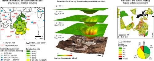
Abstract
Limited attention is typically paid to the cause-effect relationship between land subsidence due to aquifers overexploitation in expanding metropolises and urban growth models and patterns. This paper implements an integrated urban and satellite Interferometric Synthetic Aperture Radar (InSAR) approach to investigate subsidence, multi-decadal urban growth and peopling trends in the Metropolitan Area of Morelia (ZMM) in the Mexican state of Michoacán. Stacking of JRC's Global Human Settlement Layer, DLR's World Settlement Footprint and INEGI's National Geostatistical Framework datasets reveals a predominant edge-expansion growth model, with urban densification in 1975–2020 and some sprawling in 1990–2000. Population of the ZMM doubled in the last 30 years, reaching over 1 million inhabitants. The ENVISAT and Sentinel-1 InSAR analysis confirms that subsidence is structurally-controlled by the main normal faults within the Cuitzeo half-graben. Differential sinking and ground discontinuities are aligned with buried tectonic faults and contrasting compressible sediment thickness. Non-linearly deforming subsidence bowls develop at extraction wells in both old and newly urbanized sectors of the ZMM. Maximum vertical displacement velocities increased from −2.5 cm/year in 2003−2010 to −9.0 cm/year in 2014–2021, with subsidence migrating towards recently urbanized zones. More than 250 new groundwater wells were added to the public registry since 2000, many of which within new urban sectors. Time-lapse InSAR reveals a 4 km2 rapidly subsiding bowl that formed at the largest social housing neighbourhood of Villas del Pedregal, as building lots were progressively completed and sold, and new wells registered. With angular distortions due to the differential subsidence reaching 0.12% in 2014–2021, new buildings and roads are exposed to fracturing and surface faulting risk of comparable level as the city historic building blocks located along the main faults. By providing useful insights into the relationship between urban growth and land subsidence in the ZMM, the approach proves valuable for application to other metropolises worldwide.
期刊介绍:
The Science of the Total Environment is an international journal dedicated to scientific research on the environment and its interaction with humanity. It covers a wide range of disciplines and seeks to publish innovative, hypothesis-driven, and impactful research that explores the entire environment, including the atmosphere, lithosphere, hydrosphere, biosphere, and anthroposphere.
The journal's updated Aims & Scope emphasizes the importance of interdisciplinary environmental research with broad impact. Priority is given to studies that advance fundamental understanding and explore the interconnectedness of multiple environmental spheres. Field studies are preferred, while laboratory experiments must demonstrate significant methodological advancements or mechanistic insights with direct relevance to the environment.

 求助内容:
求助内容: 应助结果提醒方式:


