
Black carbon dynamics over the Northern Indian Ocean: Variability, emission sources, transport and future projections
IF 12.7
1区 地球科学
Q1 GEOSCIENCES, MULTIDISCIPLINARY
引用次数: 0
Abstract
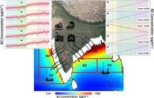
This study presents an extensive long-term assessment of black carbon (BC) over the North Indian Ocean (NIO) by integrating multiple datasets, like reanalysis, emission inventory, satellite fire counts and trajectory model, highlighting the complex interplay among emission sources, atmospheric transport, and regional climate dynamics. The findings reveal persistent BC hotspots along the northeastern and western coast of India, particularly near the northern Bay of Bengal (BoB). These hotspots are mainly linked to intense anthropogenic activities and outflows from the Indo-Gangetic Plain (IGP). The study highlights a distinct land-to-sea gradient and strong seasonal variability in BC mass concentration, with peak values during winter (up to 3.20 μg/m3) and post-monsoon seasons (up to 2.05 μg/m3) due to reduced atmospheric dispersion. BC levels increased notably during the rapid economic expansion in the 1990s and 2000s (up to 0.036 μg m−3 yr−1) but flattened after 2011, particularly in eastern coastal regions, suggesting the substantial impact of emission control and air quality regulations policies. Regional discrepancies remain, with areas like sub-regions R1 experiencing both sharp increases and significant recent declines, highlighting heterogeneous emission patterns and the effects mitigation policies. Atmospheric processes, particularly long-range transport, extensively influence BC distribution. Cluster analyses of airmass back trajectories further confirm that the BC over the BoB predominantly originates from the Indian landmass, while the Arabian Sea (AS) receives BC loading from both India and the Middle East, along with ship emissions. Agricultural fires and forest degradation contribute significantly to BC emissions, with highest fire occurrences observed between 2001 and 2010 followed by a decline, except for a fire surge in 2021. Future projections of BC mass concentration using the Seasonal Autoregressive Integrated Moving Average (SARIMA) model suggest an increasing trend during 2023–2032 across all the sub-region (up to 0.035 μg m−3 yr−1) except sub-region R3 where almost negligible decreasing trend is found (−0.002 μg m−3 yr−1). Thus, present study concludes that effective BC mitigation demands integrated emission controls, targeted regional policies, and continuous monitoring to address both local sources and transported pollution, which is crucial for improving climate and air quality in South Asia and the NIO.
北印度洋上的黑碳动态:变率、排放源、运输和未来预测
本研究通过整合再分析、排放清单、卫星火灾计数和轨迹模型等多个数据集,对北印度洋(NIO)上空的黑碳(BC)进行了广泛的长期评估,强调了排放源、大气输送和区域气候动力学之间复杂的相互作用。研究结果显示,在印度东北部和西海岸,特别是孟加拉湾北部(BoB)附近,持续存在BC热点。这些热点主要与强烈的人为活动和印度-恒河平原(IGP)的外流有关。该研究强调了BC质量浓度具有明显的陆海梯度和强烈的季节变化,冬季(高达3.20 μg/m3)和季风后季节(高达2.05 μg/m3)由于大气弥散减少而达到峰值。在20世纪90年代和21世纪初的经济快速扩张期间,BC水平显著上升(高达0.036 μ m - 3 yr - 1),但在2011年之后趋于平缓,特别是在东部沿海地区,这表明排放控制和空气质量监管政策的实质性影响。区域差异仍然存在,像R1分区域这样的地区经历了急剧增加和近期的大幅下降,突出了不同的排放模式和减缓影响的政策。大气过程,特别是长距离输送,广泛影响BC的分布。气团反轨迹的聚类分析进一步证实,印度洋上空的BC主要来自印度大陆,而阿拉伯海(AS)则同时接收来自印度和中东的BC负荷,以及船舶排放。农业火灾和森林退化对不列颠哥伦比亚省的排放贡献很大,2001年至2010年期间观察到的火灾发生率最高,随后下降,除了2021年的火灾激增。利用季节自回归综合移动平均(SARIMA)模式对BC质量浓度的未来预测表明,在2023-2032年期间,除R3子区域几乎可以忽略不计的下降趋势(- 0.002 μ m - 3 yr - 1)外,所有子区域的BC质量浓度都呈增加趋势(高达0.035 μ m - 3 yr - 1)。因此,本研究得出结论,有效缓解不列颠哥伦比亚省污染需要综合排放控制、有针对性的区域政策和持续监测,以解决当地污染源和运输污染问题,这对于改善南亚和NIO的气候和空气质量至关重要。
本文章由计算机程序翻译,如有差异,请以英文原文为准。
求助全文
约1分钟内获得全文
求助全文
来源期刊
Geoscience frontiers
Earth and Planetary Sciences-General Earth and Planetary Sciences
CiteScore
17.80
自引率
3.40%
发文量
147
审稿时长
35 days
期刊介绍:
Geoscience Frontiers (GSF) is the Journal of China University of Geosciences (Beijing) and Peking University. It publishes peer-reviewed research articles and reviews in interdisciplinary fields of Earth and Planetary Sciences. GSF covers various research areas including petrology and geochemistry, lithospheric architecture and mantle dynamics, global tectonics, economic geology and fuel exploration, geophysics, stratigraphy and paleontology, environmental and engineering geology, astrogeology, and the nexus of resources-energy-emissions-climate under Sustainable Development Goals. The journal aims to bridge innovative, provocative, and challenging concepts and models in these fields, providing insights on correlations and evolution.
 求助内容:
求助内容: 应助结果提醒方式:

 京公网安备 11010802042870号


