Long term evolution of deep banner banks offshore Brittany (France): paleo-coast line markers and interactions between hydrodynamics and seafloor morphology

IF 12.7 1区 地球科学 Q1 GEOSCIENCES, MULTIDISCIPLINARY
Geoscience frontiers Pub Date : 2026-05-01 Epub Date: 2026-01-07 DOI:10.1016/j.gsf.2026.102250
Paul Daguinos , Pascal Le Roy , Gwenael Jouët , David Menier , Nicolas Le Dantec , Axel Ehrhold , Christophe Prunier , Pauline Dupont , Marcaurelio Franzetti
{"title":"Long term evolution of deep banner banks offshore Brittany (France): paleo-coast line markers and interactions between hydrodynamics and seafloor morphology","authors":"Paul Daguinos ,&nbsp;Pascal Le Roy ,&nbsp;Gwenael Jouët ,&nbsp;David Menier ,&nbsp;Nicolas Le Dantec ,&nbsp;Axel Ehrhold ,&nbsp;Christophe Prunier ,&nbsp;Pauline Dupont ,&nbsp;Marcaurelio Franzetti","doi":"10.1016/j.gsf.2026.102250","DOIUrl":null,"url":null,"abstract":"<div><div>This study focusses on the development and evolution of a banner banks set located offshore the Britanny coast (Iroise Sea, France) using multibeam bathymetric data, high-resolution seismic data, and grab samples. It aims to provide a comprehensive understanding of environmental parameters underpinning the long-term evolution and preservation of these major morpho-sedimentary bedforms. These banks have developed on a highly dispersive tide-and-storm-dominated shelf. Despite their very contrasting morphologies, the base of each of them lies at a similar depth range (100 to 90 m). The presence of dunes superimposed on the banks suggests that they remained active until today excepting for the Armen bank. Five seismic units have been also distinguished within each bank, separated by pronounced erosional unconformities. The surfaces are interpreted as the product of the gradual flooding of the bedrock outcropping across the shelf that modified the prevailing tidal conditions and directions of sediment transport. It thus appears that correlation between sea-level rise, the opening of straits across the shelf and the intensification of tidal currents are the key parameters of the long-term sand bank evolution offshore Brittany. The stepped morphology of the bedrock also appears to be a crucial factor in the initiation of the bank and its lasting anchoring between external and internal shelf. The preservation of their original nucleus indeed attests to their low lateral migration. With the exception of the silico-clastic basal unit, the banks are biogenic and fed by a process of self-recycling the sand within the sedimentary cell controlling the preservation of the bank. This study sheds light on the mechanisms of the formation and the deep anchorage of these deep banner banks, as well as their inherent link. It also highlights the dynamic nature of these large deep bedforms that are sustained by a fossil sedimentary stock.</div></div>","PeriodicalId":12711,"journal":{"name":"Geoscience frontiers","volume":"17 3","pages":"Article 102250"},"PeriodicalIF":12.7000,"publicationDate":"2026-05-01","publicationTypes":"Journal Article","fieldsOfStudy":null,"isOpenAccess":false,"openAccessPdf":"","citationCount":"0","resultStr":null,"platform":"Semanticscholar","paperid":null,"PeriodicalName":"Geoscience frontiers","FirstCategoryId":"89","ListUrlMain":"https://www.sciencedirect.com/science/article/pii/S1674987126000046","RegionNum":1,"RegionCategory":"地球科学","ArticlePicture":[],"TitleCN":null,"AbstractTextCN":null,"PMCID":null,"EPubDate":"2026/1/7 0:00:00","PubModel":"Epub","JCR":"Q1","JCRName":"GEOSCIENCES, MULTIDISCIPLINARY","Score":null,"Total":0}
引用次数: 0

Abstract

This study focusses on the development and evolution of a banner banks set located offshore the Britanny coast (Iroise Sea, France) using multibeam bathymetric data, high-resolution seismic data, and grab samples. It aims to provide a comprehensive understanding of environmental parameters underpinning the long-term evolution and preservation of these major morpho-sedimentary bedforms. These banks have developed on a highly dispersive tide-and-storm-dominated shelf. Despite their very contrasting morphologies, the base of each of them lies at a similar depth range (100 to 90 m). The presence of dunes superimposed on the banks suggests that they remained active until today excepting for the Armen bank. Five seismic units have been also distinguished within each bank, separated by pronounced erosional unconformities. The surfaces are interpreted as the product of the gradual flooding of the bedrock outcropping across the shelf that modified the prevailing tidal conditions and directions of sediment transport. It thus appears that correlation between sea-level rise, the opening of straits across the shelf and the intensification of tidal currents are the key parameters of the long-term sand bank evolution offshore Brittany. The stepped morphology of the bedrock also appears to be a crucial factor in the initiation of the bank and its lasting anchoring between external and internal shelf. The preservation of their original nucleus indeed attests to their low lateral migration. With the exception of the silico-clastic basal unit, the banks are biogenic and fed by a process of self-recycling the sand within the sedimentary cell controlling the preservation of the bank. This study sheds light on the mechanisms of the formation and the deep anchorage of these deep banner banks, as well as their inherent link. It also highlights the dynamic nature of these large deep bedforms that are sustained by a fossil sedimentary stock.
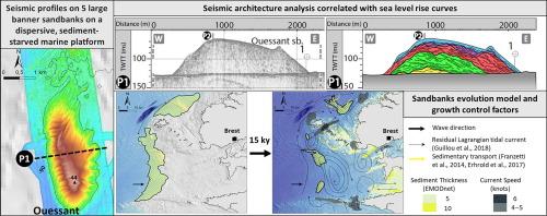
Abstract Image

法国布列塔尼近海深旗滩的长期演化:古海岸线标志和水动力与海底形态的相互作用
本研究利用多波束测深数据、高分辨率地震数据和抓拍样本,重点研究布列塔尼海岸(法国Iroise海)近海旗滩的发展和演变。它的目的是提供对这些主要形态-沉积层的长期演化和保存的环境参数的全面理解。这些河岸是在高度分散的潮汐和风暴主导的陆架上发展起来的。尽管它们的形态截然不同,但它们的底部都位于相似的深度范围(100至90米)。河岸上叠加的沙丘的存在表明,它们直到今天仍然活跃,除了阿门河岸。在每条河岸内还划分出5个地震单元,由明显的侵蚀不整合面分开。这些表面被解释为陆架上露出地面的基岩逐渐被淹没的产物,这改变了当时的潮汐条件和沉积物运输的方向。由此可见,海平面上升、跨陆架海峡的开放和潮流的强化之间的相关性是布列塔尼近海沙洲长期演化的关键参数。基岩的阶梯式形态似乎也是河岸形成及其在内外陆架之间持久锚固的关键因素。其原始细胞核的保存确实证明了它们的低横向迁移。除了硅碎屑基单元外,河岸是由生物形成的,并由沉积细胞内的沙子自我循环过程滋养,控制着河岸的保存。本研究揭示了这些深旗滩的形成机制和深锚,以及它们之间的内在联系。它还突出了这些由化石沉积群维持的大型深层河床的动态性质。
本文章由计算机程序翻译,如有差异,请以英文原文为准。
求助全文
约1分钟内获得全文 求助全文
来源期刊
Geoscience frontiers
Geoscience frontiers Earth and Planetary Sciences-General Earth and Planetary Sciences
CiteScore
17.80
自引率
3.40%
发文量
147
审稿时长
35 days
期刊介绍: Geoscience Frontiers (GSF) is the Journal of China University of Geosciences (Beijing) and Peking University. It publishes peer-reviewed research articles and reviews in interdisciplinary fields of Earth and Planetary Sciences. GSF covers various research areas including petrology and geochemistry, lithospheric architecture and mantle dynamics, global tectonics, economic geology and fuel exploration, geophysics, stratigraphy and paleontology, environmental and engineering geology, astrogeology, and the nexus of resources-energy-emissions-climate under Sustainable Development Goals. The journal aims to bridge innovative, provocative, and challenging concepts and models in these fields, providing insights on correlations and evolution.

×
引用
GB/T 7714-2015
复制
MLA
复制
APA
复制
导出至
BibTeX EndNote RefMan NoteFirst NoteExpress
×
提示
您的信息不完整,为了账户安全,请先补充。
现在去补充
×
提示
您因"违规操作"
具体请查看互助需知
我知道了
×
提示
确定
请完成安全验证×
copy
已复制链接
快去分享给好友吧!
我知道了
右上角分享
点击右上角分享
0
联系我们:info@booksci.cn Book学术提供免费学术资源搜索服务,方便国内外学者检索中英文文献。致力于提供最便捷和优质的服务体验。 Copyright © 2023 布克学术 All rights reserved.
京ICP备2023020795号-1
ghs 京公网安备 11010802042870号
Book学术文献互助
Book学术文献互助群
群 号:604180095
Book学术官方微信
小红书