
Spatiotemporal analysis of the FWI over Europe and North Africa: Historical trends and climate projections under RCP4.5 and RCP8.5
IF 12.7
1区 地球科学
Q1 GEOSCIENCES, MULTIDISCIPLINARY
引用次数: 0
Abstract
Wildfires represent an escalating environmental threat across Europe and North Africa, increasingly exacerbated by climate-driven shifts in temperature, precipitation, and drought patterns. However, there is still limited large-scale, methodologically consistent research that simultaneously assesses historical patterns and future projections of fire danger across these regions, particularly in terms of both frequency and duration of risk under different climate scenarios. This study addresses this gap by providing a high-resolution, spatiotemporal assessment of fire weather conditions, with the aim of offering critical insights to support climate-adaptive fire management strategies, extended preparedness frameworks, and the integration of future fire weather projections into land-use and risk governance policies. To achieve this, we investigate historical (1979–2021) and projected (2000–2098) trends in fire danger using the Canadian Fire Weather Index (FWI), based on ERA5 reanalysis data and outputs from five Global Climate Models (GCMs) under RCP4.5 and RCP8.5 scenarios. Over 50,000 land grid cells were analyzed to assess the frequency and duration of six FWI danger classes. Different metrics were used to quantify the agreement between historical reanalysis data and GCM outputs, while the Seasonal Kendall (SK) test was applied to detect trends. Results reveal a substantial decline in the duration of the very low FWI class, from 36 to 23 months, and significant increases in both the duration and frequency of the extreme FWI class, reaching up to 6.38 months and 14.42% under the RCP8.5 scenario. Correlation coefficients exceed 0.8 across much of Southern Europe and North Africa, indicating strong temporal agreement. Trend analyses reveal statistically significant increases in fire danger across southern latitudes, while Northern Europe shows mixed or decreasing trends. These findings project a dramatic intensification and expansion of fire-prone conditions, particularly under high-emission scenarios.
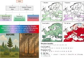
欧洲和北非FWI的时空分析:RCP4.5和RCP8.5下的历史趋势和气候预估
野火对整个欧洲和北非的环境威胁不断升级,气候驱动的温度、降水和干旱模式的变化日益加剧了这种威胁。然而,同时评估这些地区火灾危险的历史模式和未来预测的大规模、方法一致的研究仍然有限,特别是在不同气候情景下风险的频率和持续时间方面。本研究通过提供火灾天气条件的高分辨率时空评估来解决这一差距,旨在为支持气候适应性火灾管理战略、扩展准备框架以及将未来火灾天气预测整合到土地利用和风险治理政策中提供关键见解。为了实现这一目标,我们基于ERA5再分析数据和五个全球气候模式(GCMs)在RCP4.5和RCP8.5情景下的输出,利用加拿大火灾天气指数(FWI)调查了历史(1979-2021)和预测(2000-2098)的火灾危险趋势。研究人员对超过50,000个陆地电网单元进行了分析,以评估六种FWI危险级别的频率和持续时间。使用不同的指标来量化历史再分析数据与GCM输出之间的一致性,而使用季节性肯德尔(SK)检验来检测趋势。结果显示,极低FWI等级的持续时间从36个月大幅下降至23个月,而极端FWI等级的持续时间和频率均显著增加,在RCP8.5情景下达到6.38个月和14.42%。在南欧和北非的大部分地区,相关系数超过0.8,表明具有很强的时间一致性。趋势分析显示,在统计上,南纬地区的火灾危险显著增加,而北欧则呈现混合趋势或下降趋势。这些发现预测了火灾易发条件的急剧加剧和扩大,特别是在高排放情景下。
本文章由计算机程序翻译,如有差异,请以英文原文为准。
求助全文
约1分钟内获得全文
求助全文
来源期刊
Geoscience frontiers
Earth and Planetary Sciences-General Earth and Planetary Sciences
CiteScore
17.80
自引率
3.40%
发文量
147
审稿时长
35 days
期刊介绍:
Geoscience Frontiers (GSF) is the Journal of China University of Geosciences (Beijing) and Peking University. It publishes peer-reviewed research articles and reviews in interdisciplinary fields of Earth and Planetary Sciences. GSF covers various research areas including petrology and geochemistry, lithospheric architecture and mantle dynamics, global tectonics, economic geology and fuel exploration, geophysics, stratigraphy and paleontology, environmental and engineering geology, astrogeology, and the nexus of resources-energy-emissions-climate under Sustainable Development Goals. The journal aims to bridge innovative, provocative, and challenging concepts and models in these fields, providing insights on correlations and evolution.
 求助内容:
求助内容: 应助结果提醒方式:

 京公网安备 11010802042870号


