Synthetic aperture radar for a changing planet: A 25-year global synthesis in hazard assessment, urban development, and ecological applications
IF 7.3
2区 环境科学与生态学
Q1 ECOLOGY
引用次数: 0
Abstract
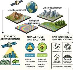
The increasing frequency and intensity of natural disasters, rapid urbanization, and accelerating ecological degradation underscore the urgent need for robust monitoring tools. Over the past two and a half decades, Synthetic Aperture Radar (SAR) technology has transformed the landscape of remote sensing, offering unique capabilities for all-weather, day-and-night imaging. SAR applications have expanded dramatically into critical domains such as hazard assessment, urban development, and ecological management. Despite significant progress, fragmented knowledge, uneven adoption across geographies, and several technical, methodological, and application-specific challenges continue to constrain its full potential. This systematic review synthesizes the global research trends, technological evolution, application domains, and persisting bottlenecks in SAR utilization across three key thematic areas: hazard assessment, urban development, and ecological management over the past 25 years (2000–2024), supported by a comprehensive bibliometric analysis of 11,201 peer-reviewed publications indexed in the Scopus database. Unlike previous reviews that often focus on narrow applications or specific sensor types, this review offers a holistic, cross-sectoral, and longitudinal perspective, identifying emerging trends, underexplored geographies, and growing intersections with novel computational frameworks. The study employed a systematic review protocol based on PRISMA guidelines, combined with bibliometric techniques using VOSviewer and Bibliometrix (R-package). The articles were retrieved using a well-defined keyword query related to SAR, hazards, urban studies, and ecosystems. Analyses included publication trends, co-authorship networks, keyword co-occurrence, source impact, and thematic evolution. Cluster analysis identified four major research themes and three temporal development phases. Results indicate that publications increased nearly tenfold from 2000 to 2024, with a peak after 2015 due to the launch of Sentinel-1 and the rise of open data. Major contributing countries include China, USA, Italy, Germany, and India, with strong international collaborations. Interferometric SAR (InSAR) and Polarimetric SAR (PolSAR) dominated hazard and urban studies, while multi-temporal-based approaches emerged in ecological monitoring. Notably, integration with AI and cloud-based geospatial platforms remains limited (<15 % of publications). Urban development applications, especially subsidence and infrastructure monitoring, show the fastest growth, while ecological applications lag, indicating a critical research gap. Furthermore, this review underscores that while SAR has made substantial strides, methodological integration, capacity building in the Global South, and translation into policy-oriented tools remain key challenges. The findings advocate for multi-sensor synergy, open-data initiatives, and interdisciplinary collaborations as pathways to expand SAR's impact. Overall, this review serves as a reference point for researchers, practitioners, and policymakers aiming to harness SAR for sustainable development and disaster resilience in the coming decades.
变化的地球上的合成孔径雷达:25年来危害评估、城市发展和生态应用的全球综合
自然灾害的频率和强度不断增加,城市化迅速发展,生态退化加速,这些都突出表明迫切需要强有力的监测工具。在过去的25年里,合成孔径雷达(SAR)技术改变了遥感领域的格局,为全天候、昼夜成像提供了独特的能力。SAR应用已迅速扩展到危害评估、城市发展和生态管理等关键领域。尽管取得了重大进展,但分散的知识、不同地区采用的不均衡以及一些技术、方法和特定应用的挑战继续限制其充分发挥潜力。本系统综述综合了过去25年(2000-2024年)在灾害评估、城市发展和生态管理三个关键主题领域SAR利用的全球研究趋势、技术演变、应用领域和持续瓶颈,并对Scopus数据库中11,201篇同行评议出版物进行了全面的文献计量分析。与以往的综述不同,该综述提供了一个整体的、跨部门的、纵向的视角,确定了新兴趋势、未开发的地理区域以及与新型计算框架的交叉点。本研究采用基于PRISMA指南的系统评价方案,结合使用VOSviewer和Bibliometrix (R-package)的文献计量技术。文章检索使用定义明确的关键字查询相关的SAR,危害,城市研究,和生态系统。分析包括出版趋势、合著网络、关键词共现、来源影响和主题演变。聚类分析确定了四个主要研究主题和三个时间发展阶段。结果表明,从2000年到2024年,论文发表量增长了近10倍,2015年之后,由于Sentinel-1的发射和开放数据的兴起,论文发表量达到峰值。主要贡献国包括中国、美国、意大利、德国和印度,并有强有力的国际合作。干涉SAR (InSAR)和偏振SAR (PolSAR)在灾害和城市研究中占主导地位,而基于多时间的方法在生态监测中出现。值得注意的是,与人工智能和基于云的地理空间平台的整合仍然有限(占出版物的15%)。城市发展应用,特别是沉降和基础设施监测,增长最快,而生态应用滞后,表明一个关键的研究空白。此外,本综述强调,虽然特别评估取得了实质性进展,但方法整合、全球南方的能力建设以及将其转化为面向政策的工具仍然是主要挑战。研究结果提倡将多传感器协同、开放数据倡议和跨学科合作作为扩大SAR影响的途径。总的来说,这篇综述为未来几十年旨在利用SAR促进可持续发展和抗灾能力的研究人员、从业者和决策者提供了参考点。
本文章由计算机程序翻译,如有差异,请以英文原文为准。
求助全文
约1分钟内获得全文
求助全文
来源期刊

Ecological Informatics
环境科学-生态学
CiteScore
8.30
自引率
11.80%
发文量
346
审稿时长
46 days
期刊介绍:
The journal Ecological Informatics is devoted to the publication of high quality, peer-reviewed articles on all aspects of computational ecology, data science and biogeography. The scope of the journal takes into account the data-intensive nature of ecology, the growing capacity of information technology to access, harness and leverage complex data as well as the critical need for informing sustainable management in view of global environmental and climate change.
The nature of the journal is interdisciplinary at the crossover between ecology and informatics. It focuses on novel concepts and techniques for image- and genome-based monitoring and interpretation, sensor- and multimedia-based data acquisition, internet-based data archiving and sharing, data assimilation, modelling and prediction of ecological data.
 求助内容:
求助内容: 应助结果提醒方式:


