Deciphering spatio-seasonal impacts of agricultural irrigation on water quality evolution and surface water-groundwater interaction in a large irrigation district, northwest China
IF 6.3
1区 地球科学
Q1 ENGINEERING, CIVIL
引用次数: 0
Abstract
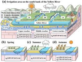
The irrigation area on the south bank of the Yellow River (IASBYR) in Hangjin Banner, Ordos, China is an important strategic base for grain production in northern China. Yet its complex hydrogeological setting and insufficient monitoring data have limited understanding of water quality dynamics and surface water-groundwater interactions (SWIs). This study employed hydrochemical and isotopic analyses (258 samples), entropy-weighted water quality index (EWQI), positive matrix factorization (PMF), and 222Rn mass balance modeling (RMBM) to investigate these processes. Results revealed that groundwater and canal water were predominantly brackish to saline, contrasting with the freshwater of the Yellow River. Water quality degradation was controlled by nitrogen/fluoride contamination and water–rock interactions (WRIs; evaporite dissolution and silicate weathering), with 83 % of groundwater, 60 % of canal water, and 13 % of Yellow River water deemed non-potable due to excessive total nitrogen (TN). Spatially, SWIs exhibited distinct zonation: river leakage dominated in the upper reaches, with the flux rate (qr) of 5.87 × 10⁻⁴m3/(s∙m), while groundwater discharge flux rate (qg) is 1.45 × 10⁻⁴m3/(s∙m)). Minimal exchange occurred in the middle reaches (qr: 2.93 × 10⁻⁴m3/(s∙m), qg: 0.32 × 10⁻⁴m3/(s∙m)), and groundwater discharged into the river in the lower reaches (qr: −16.06 × 10⁻⁴m3/(s∙m), qg: 0.64 × 10⁻⁴m3/(s∙m)). Temporally, groundwater discharge prevailed during the spring and summer irrigation periods, while river leakage and groundwater discharge occurred in the autumn irrigation period. SWIs critically governed TN and F- migration, with excessive nitrogen inputs driving eutrophication of riparian wetlands and elevated fluoride concentrations can be hazardous to human health. The findings offer critical insights for optimizing agricultural water management and ecological conservation in the Yellow River Basin.
西北大型灌区农业灌溉对水质演变及地表水-地下水相互作用的时空影响解析
鄂尔多斯杭锦旗黄河南岸灌区(IASBYR)是中国北方重要的粮食生产战略基地。然而,其复杂的水文地质环境和监测数据的不足,限制了对水质动态和地表水-地下水相互作用(SWIs)的认识。本研究采用水化学和同位素分析(258份样品)、熵加权水质指数(EWQI)、正矩阵分解(PMF)和222Rn质量平衡模型(RMBM)对这些过程进行了研究。结果表明,地下水和运河水以微咸至咸水为主,与黄河的淡水形成鲜明对比。水质退化受氮/氟化物污染和水岩相互作用(WRIs;蒸发岩溶解和硅酸盐风化)控制,83%的地下水、60%的运河水和13%的黄河水因总氮(TN)超标而被视为不可饮用。空间上具有明显的地带性,上游以河流渗漏为主,通量率(qr)为5.87 × 10-4m3/(s∙m),地下水排放通量率(qg)为1.45 × 10-4m3/(s∙m)。中游交换量最小(qr: 2.93 × 10⁻⁴m3/(s∙m), qg: 0.32 × 10⁻⁴m3/(s∙m)),下游排入河流的地下水最小(qr:−16.06 × 10-4m3/(s∙m), qg: 0.64 × 10⁻⁴m3/(s∙m))。从时间上看,春、夏季灌溉期以地下水排放为主,秋季灌溉期以河水渗漏和地下水排放为主。SWIs严重控制着TN和F的迁移,过量的氮输入导致河岸湿地富营养化,氟化物浓度升高可能对人类健康有害。研究结果对优化黄河流域农业用水管理和生态保护具有重要意义。
本文章由计算机程序翻译,如有差异,请以英文原文为准。
求助全文
约1分钟内获得全文
求助全文
来源期刊

Journal of Hydrology
地学-地球科学综合
CiteScore
11.00
自引率
12.50%
发文量
1309
审稿时长
7.5 months
期刊介绍:
The Journal of Hydrology publishes original research papers and comprehensive reviews in all the subfields of the hydrological sciences including water based management and policy issues that impact on economics and society. These comprise, but are not limited to the physical, chemical, biogeochemical, stochastic and systems aspects of surface and groundwater hydrology, hydrometeorology and hydrogeology. Relevant topics incorporating the insights and methodologies of disciplines such as climatology, water resource systems, hydraulics, agrohydrology, geomorphology, soil science, instrumentation and remote sensing, civil and environmental engineering are included. Social science perspectives on hydrological problems such as resource and ecological economics, environmental sociology, psychology and behavioural science, management and policy analysis are also invited. Multi-and interdisciplinary analyses of hydrological problems are within scope. The science published in the Journal of Hydrology is relevant to catchment scales rather than exclusively to a local scale or site.
 求助内容:
求助内容: 应助结果提醒方式:


