Multi-phase intra-plate rifting and deformable plate modelling of the Northeast Atlantic back to the Permian
IF 7.2
1区 地球科学
Q1 GEOSCIENCES, MULTIDISCIPLINARY
引用次数: 0
Abstract
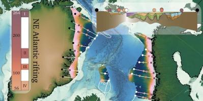
The Northeast Atlantic was one of the last regions of the Pangea supercontinent to undergo complete break-up, experiencing over 200 million years of episodic continental stretching before final separation. This prolonged tectonic evolution has been studied using recent geological and geophysical data obtained from the mid-Norwegian and East Greenland margins, which provide constraints on the timing, location, amount, and direction of extension. To analyse these parameters, we adopt a basin-to-plate scale approach and develop a deformable plate reconstruction. We implement four discrete phases of rifting: Phase I (264–247 Ma), Phase II (166–140 Ma), Phase III (125–110 Ma), Phase IV (80–56 Ma), with a progressive shift in extension direction from east-west to southeast-northwest. A key component of our methodology is the restoration of basin hinges for each rift episode. These hinges mark the outermost rigid boundaries of the deforming region and provide essential structural constraints. Over time, the width of the rifting domain narrows from approximately 300 km to 220 km, depending on margin location. Our model predicts cumulative stretching ranging from 240 km in the north to 310 km in the south of the domain. Extension rates and amounts vary by phase; for a mid-margin location, Phase I accounts for approximately 90 km of extension at 0.5 cm/yr, Phase II for 30 km at 0.13 cm/yr, Phase III for 90 km at 0.58 cm/yr, and Phase IV for 80 km at 0.32 cm/yr. By comparing forwards- and backwards-in-time crustal thickness reconstructions, our results suggest an initial crustal thickness exceeding 35 km before the onset of Permian rifting, and that lateral variations of non-linear stretching were likely. Our framework indicates that both rigid and deforming reconstructions should be developed in tandem with regional basin-scale constraints. Our model will form the basis for additional regional temporal and structural investigations including the Barents Sea, North Sea, and Northwest North Atlantic.
回溯至二叠纪的东北大西洋多期板内裂陷与变形板块模拟
东北大西洋是盘古大陆最后经历完全分裂的地区之一,在最终分离之前经历了超过2亿年的间歇性大陆拉伸。研究人员利用挪威中部和东格陵兰边缘最近获得的地质和地球物理数据研究了这种漫长的构造演化,这些数据提供了扩展的时间、位置、数量和方向的限制。为了分析这些参数,我们采用盆地到板块的尺度方法,并开发了可变形板块重建。我们实施了四个离散的阶段:阶段1 (264-247 Ma),阶段2 (166-140 Ma),阶段3 (125-110 Ma),阶段4 (80-56 Ma),扩展方向从东-西向东南-西北逐步转移。我们方法论的一个关键组成部分是为每个裂谷片段恢复盆地铰链。这些铰链标志着变形区域的最外层刚性边界,并提供必要的结构约束。随着时间的推移,裂谷区的宽度从大约300公里缩小到220公里,这取决于边缘位置。我们的模型预测的累积伸展范围从北部240公里到南部310公里。扩展率和数量因阶段而异;在中间边缘位置,一期工程以0.5 cm/年的速度扩展约90公里,二期工程以0.13 cm/年的速度扩展30公里,三期工程以0.58 cm/年的速度扩展90公里,四期工程以0.32 cm/年的速度扩展80公里。通过对比前后时间的地壳厚度重建,我们的结果表明,在二叠纪裂陷开始之前,地壳的初始厚度超过35 km,并且可能存在非线性拉伸的横向变化。我们的框架表明,刚性和变形重建都应与区域盆地尺度约束相结合。我们的模型将成为其他区域时间和结构调查的基础,包括巴伦支海、北海和北大西洋西北部。
本文章由计算机程序翻译,如有差异,请以英文原文为准。
求助全文
约1分钟内获得全文
求助全文
来源期刊
Gondwana Research
地学-地球科学综合
CiteScore
12.90
自引率
6.60%
发文量
298
审稿时长
65 days
期刊介绍:
Gondwana Research (GR) is an International Journal aimed to promote high quality research publications on all topics related to solid Earth, particularly with reference to the origin and evolution of continents, continental assemblies and their resources. GR is an "all earth science" journal with no restrictions on geological time, terrane or theme and covers a wide spectrum of topics in geosciences such as geology, geomorphology, palaeontology, structure, petrology, geochemistry, stable isotopes, geochronology, economic geology, exploration geology, engineering geology, geophysics, and environmental geology among other themes, and provides an appropriate forum to integrate studies from different disciplines and different terrains. In addition to regular articles and thematic issues, the journal invites high profile state-of-the-art reviews on thrust area topics for its column, ''GR FOCUS''. Focus articles include short biographies and photographs of the authors. Short articles (within ten printed pages) for rapid publication reporting important discoveries or innovative models of global interest will be considered under the category ''GR LETTERS''.
 求助内容:
求助内容: 应助结果提醒方式:


